Scooba, Mississippi | |
---|---|
Town of Scooba | |
Coordinates: 32°49′41.5″N88°28′35.1″W / 32.828194°N 88.476417°W | |
Country | United States |
State | Mississippi |
County | Kemper |
District | 1 |
Founded | December 13, 1858 |
Incorporated | April 9, 1873 |
Named for | Choctaw: scooba ("Reed brake") |
Government | |
• Type | Mayor–Council |
• Mayor | Craig N. Nave Sr. (I) |
• Council | Board of Aldermen |
Area | |
• Total | 2.48 sq mi (6.42 km2) |
• Land | 2.48 sq mi (6.42 km2) |
• Water | 0.00 sq mi (0.00 km2) |
Elevation | 213 ft (65 m) |
Population (2020) | |
• Total | 744 |
• Density | 300.12/sq mi (115.88/km2) |
Time zone | UTC-6 (Central (CST)) |
• Summer (DST) | UTC-5 (CDT) |
ZIP code | 39358 |
Area code | 662 |
FIPS code | 28-66160 |
GNIS feature ID | 677458 [2] |
Highways | |
Major airport | Jackson Airport (JAN) |
Website | townofscooba |
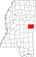
Scooba is a town in Kemper County, Mississippi, United States. Founded in 1858, [3] the population was 744 as of the 2020 Census.
Scooba is a Choctaw word meaning "reed brake" (i.e., a farming tool used on reeds), and the early settlement was noted for its productive farmland. [4]
The first permanent settlement at Scooba was made in the 1830s. [5] A line of the Gulf, Mobile and Ohio Railroad passed through Scooba. A Democratic weekly newspaper, The Kemper Herald, was established in Scooba in 1876. By the early 1900s, Scooba had several residential homes, a hotel, a livery barn, a post office, two saw milling plants, a cotton gin, a general store, five churches (three white and two colored), a school, and a bank (the Bank of Kemper, established in 1904). Scooba was a local market for cotton. [4]
In late December 1906, Scooba and Wahalak, Mississippi, were the sites of white rioting against blacks. In the various conflicts, which started with confrontations between passengers and conductors on the railroad, a total of 12 blacks and two whites were killed by December 26. The county sheriff called in the state militia for assistance. The events were covered by national newspapers. [6]
According to the United States Census Bureau, the town has a total area of 2.5 square miles (6.5 km2), all land. Scooba is adjacent to U.S. Route 45, Mississippi Highway 16, and a railroad. It is 35 miles (56 km) north of Meridian and 50 miles (80 km) south of Columbus. [7]
Census | Pop. | Note | %± |
---|---|---|---|
1900 | 286 | — | |
1910 | 322 | 12.6% | |
1920 | 700 | 117.4% | |
1930 | 933 | 33.3% | |
1940 | 606 | −35.0% | |
1950 | 734 | 21.1% | |
1960 | 513 | −30.1% | |
1970 | 626 | 22.0% | |
1980 | 511 | −18.4% | |
1990 | 541 | 5.9% | |
2000 | 632 | 16.8% | |
2010 | 732 | 15.8% | |
2020 | 744 | 1.6% | |
U.S. Decennial Census [8] |
Race | Num. | Perc. |
---|---|---|
White | 186 | 25.0% |
Black or African American | 539 | 72.45% |
Native American | 11 | 1.48% |
Other/Mixed | 4 | 0.54% |
Hispanic or Latino | 4 | 0.54% |
As of the 2020 United States Census, there were 744 people, 191 households, and 107 families residing in the town.
As of the census [10] of 2000, there were 632 people, 204 households, and 139 families residing in the town. The population density was 257.3 inhabitants per square mile (99.3/km2). There were 244 housing units at an average density of 99.3 per square mile (38.3/km2). The racial makeup of the town was 54.91% African American, 44.30% White, 0.16% from other races, and 0.63% from two or more races. Hispanic or Latino of any race were 0.79% of the population.
There were 204 households, out of which 38.2% had children under the age of 18 living with them, 38.7% were married couples living together, 27.9% had a female householder with no husband present, and 31.4% were non-families. 30.4% of all households were made up of individuals, and 10.8% had someone living alone who was 65 years of age or older. The average household size was 2.47 and the average family size was 3.09.
In the town, the population was spread out, with 23.6% under the age of 18, 29.7% from 18 to 24, 19.5% from 25 to 44, 17.4% from 45 to 64, and 9.8% who were 65 years of age or older. The median age was 22 years. For every 100 females, there were 127.3 males. For every 100 females age 18 and over, there were 134.5 males.
The median income for a household in the town was $18,875, and the median income for a family was $31,375. Males had a median income of $30,500 versus $29,063 for females. The per capita income for the town was $12,110. About 30.3% of families and 25.5% of the population were below the poverty line, including 27.2% of those under age 18 and 15.0% of those age 65 or over.
The Town of Scooba is served by the Kemper County School District. The main campus of East Mississippi Community College, including the college system's administrative headquarters, is in Scooba. [7] EMCC was featured on the Netflix documentary Last Chance U , which chronicled their 2015 and 2016 football seasons. [11] [ citation needed ]
Kemper County is a county located on the central eastern border of the U.S. state of Mississippi. As of the 2020 census, the population was 8,988. Its county seat is De Kalb. The county is named in honor of Reuben Kemper.
McGeheemə-GHEE is a city in Desha County, Arkansas, United States. The population was 4,219 at the 2010 census.
Panola is a village in Woodford County, Illinois, United States. The population was 45 at the 2010 census. It is part of the Peoria, Illinois Metropolitan Statistical Area.
Meriden is a city in Jefferson County, Kansas, United States. As of the 2020 census, the population of the city was 744.
Glen is a town in Alcorn County, Mississippi. The population was 382 at the 2020 census, down from 412 at the 2010 census.
Boyle is a town in Bolivar County, Mississippi, United States. The population was 650 at the 2010 census.
Renova is a town in Bolivar County, Mississippi, United States. Per the 2020 census, the population was 676. The community was founded by African Americans and remains predominantly African American.
Rosedale is a city in Bolivar County, Mississippi, United States. The population was 1,873 at the 2010 census, down from 2,414 in 2000. Located in an agricultural area, the city had a stop on the Yazoo and Mississippi Valley Railroad, which carried many migrants north out of the area in the first half of the 20th century.
Ackerman is a town and the county seat of Choctaw County, Mississippi, United States. The population was 1,594 according to 2020 census, which shows an increase from 1,510 reported in the 2010 census.
De Kalb is a town in and the county seat of Kemper County, Mississippi, United States. The population was 1,164 at the 2010 census. De Kalb is named after General Johann de Kalb, a Franconian-French military officer who served as a major general in the Continental Army during the American Revolutionary War.
Summit is a town in Pike County, Mississippi, United States. The population was 1,705 at the 2010 census. It is part of the McComb, Mississippi Micropolitan Statistical Area.
Pelahatchie is a town in Rankin County, Mississippi, United States. The town's population was 1,334 at the 2010 census. It is part of the Jackson, Mississippi Metropolitan Statistical Area. Its zip code is 39145.
Myrtle is a town in Union County, Mississippi, United States. The population was 490 at the 2010 census.
New Albany is a city in and the county seat of Union County, Mississippi, United States. According to the 2020 United States Census, the population was 7,626.
Coldwater is a town in Tate County, Mississippi, United States, and is part of the Memphis Metropolitan Area. The population was 1,677 at the 2010 census.
Pettus is a census-designated place (CDP) in Bee County, Texas, United States. The population was 449 at the 2020 census.
Buffalo is a town in Buffalo County in the U.S. state of Wisconsin. The population was 705 at the 2010 census. The unincorporated communities of Bluff Siding and Marshland, and East Winona railroad junction, are located in the town.
Cadiz is a town in Green County, Wisconsin, United States. The population was 863 at the 2000 census. The unincorporated community of Martintown is located in the town.
Bogue Chitto is a census-designated place (CDP) situated in Kemper and Neshoba counties, Mississippi. The population was 864 at the 2020 census. It is part of the Mississippi Band of Choctaw Indians Reservation and the population is 93% Choctaw.
Whitakers is a town in Edgecombe and Nash Counties in the U.S. state of North Carolina. It is divided between the two counties by railroad tracks and is the northernmost town in the two counties. It is part of the Rocky Mount, North Carolina Metropolitan Statistical Area. The population was 744 in 2010.