Seddington

Last updated
Seddington
Bedfordshire UK location map.svg
Red pog.svg
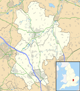
Seddington
Location within Bedfordshire
OS grid reference TL174478
Civil parish
Unitary authority
Ceremonial county
Region
Country England
Sovereign state United Kingdom
Post town SANDY
Postcode district SG19
Dialling code 01767
Police Bedfordshire
Fire Bedfordshire and Luton
Ambulance East of England
EU Parliament East of England
UK Parliament
List of places
UK
England
Bedfordshire
52°06′59″N0°17′09″W / 52.11631°N 0.28582°W / 52.11631; -0.28582 Coordinates: 52°06′59″N0°17′09″W / 52.11631°N 0.28582°W / 52.11631; -0.28582

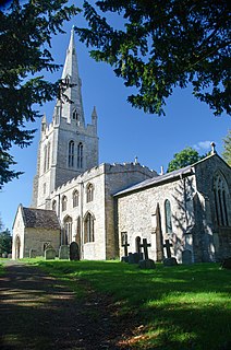
Seddington is a hamlet located in the Central Bedfordshire district of Bedfordshire, England.

Hamlet (place) Small human settlement in a rural area

A hamlet is a small human settlement. In different jurisdictions and geographies, hamlets may be the size of a town, village or parish, be considered a smaller settlement or subdivision or satellite entity to a larger settlement. The word and concept of a hamlet have roots in the Anglo-Norman settlement of England, where the old French hamlet came to apply to small human settlements. In British geography, a hamlet is considered smaller than a village and distinctly without a church or other place of worship.

Central Bedfordshire Unitary Authority in England

Central Bedfordshire is a unitary authority area in the ceremonial county of Bedfordshire, England. It was created from the merger of Mid Bedfordshire and South Bedfordshire District Councils on 1 April 2009. With a budget of £500m the unitary council provides over a hundred services to a quarter of a million people, and is responsible for schools, social services, rubbish collection, roads, planning, leisure centres, libraries, care homes and more.

Bedfordshire County of England

Bedfordshire is a county in the East of England. It is a ceremonial county and a historic county, covered by three unitary authorities: Bedford, Central Bedfordshire, and Luton.

Originally part of the historic Wixamtree hundred, Seddington was then part of the Northill civil parish until 1933 when it was transferred to Sandy. [1] Today, the settlement straddles the A1 road, south of Beeston.

Wixamtree human settlement in United Kingdom

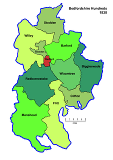
Wixamtree is an ancient hundred located in Bedfordshire, England.

Northill farm village in the United Kingdom

Northill is a village and civil parish in the county of Bedfordshire, England. It falls under the Northill and Blunham ward in the Central Bedfordshire local authority. In 2001 Northill had a population of about 900 people. The village is also the administrative centre of the civil parish of Northill, which in 2001 had a population of 2,288, reducing to 2,270 at the 2011 Census. The parish includes the hamlets of Budna, Lower and Upper Caldecote, Hatch, Ickwell and Thorncote Green.

Civil parish Territorial designation and lowest tier of local government in England

In England, a civil parish is a type of administrative parish used for local government, they are a territorial designation which is the lowest tier of local government below districts and counties, or their combined form, the unitary authority. Civil parishes can trace their origin to the ancient system of ecclesiastical parishes which historically played a role in both civil and ecclesiastical administration; civil and religious parishes were formally split into two types in the 19th century and are now entirely separate. The unit was devised and rolled out across England in the 1860s.

Related Research Articles

Leighton Buzzard town in Bedfordshire, England

Leighton Buzzard is a town in Bedfordshire, England, near the Chiltern Hills and lying between Luton and Milton Keynes. It adjoins Linslade and the name Leighton Linslade is sometimes used to refer to the combination of the two towns; parts of this article also apply to Linslade as well as Leedon. For local government purposes, the town is part of the Central Bedfordshire district and is administered jointly with Linslade as the civil parish of Leighton-Linslade.

Studham farm village in the United Kingdom

Studham is a village and civil parish in the county of Bedfordshire. It has a population of 1,128. The parish bounds to the south of the Buckinghamshire border, and to the east is the Hertfordshire border. The village lies in the wooded south facing dip slope of the Chiltern Hills. The hamlet of Holywell is located to the north of Studham, and forms part of the same civil parish.

Borough of Bedford Unitary Authority & Borough in England

Bedford is a unitary authority area with borough status in the ceremonial county of Bedfordshire, England. Its council is based at Bedford, the county town of Bedfordshire. The borough contains one large urban area, the 71st largest in the United Kingdom that comprises Bedford and the adjacent town of Kempston, surrounded by a rural area with many villages. 75% of the borough's population live in the Bedford Urban Area and the five large villages which surround it, which makes up slightly less than 6% of the total land area of the Borough.

Civil parishes in Bedfordshire Wikimedia list article

A civil parish is a country subdivision, forming the lowest unit of local government in England. There are 125 civil parishes in the ceremonial county of Bedfordshire, most of the county being parished: Luton is completely unparished; Central Bedfordshire is entirely parished. At the 2001 census, there were 312,301 people living in the 125 parishes, which accounted for 55.2 per cent of the county's population.

Astwick farm village in the United Kingdom

Astwick is a hamlet and civil parish in the Central Bedfordshire district of the county of Bedfordshire, England about 12.5 miles (20 km) south-east of the county town of Bedford. Its population is included within Stotfold civil parish.

Chalgrave farm village in the United Kingdom

Chalgrave is a civil parish in the Central Bedfordshire district of Bedfordshire, England. The hamlets of Tebworth and Wingfield are in the west of the parish, with the church and manor in the east. Nearby places are Toddington, Chalton, Houghton Regis, and Hockliffe. Before 1929, the parish also included part of the village of Hockliffe.

Stanbridge, Bedfordshire village and civil parish in Bedfordshire, England

Stanbridge is a village and civil parish in Bedfordshire which lies 3 miles (5 km) east of Leighton Buzzard. It also borders the Bedfordshire villages of Hockliffe, Eggington, Tilsworth, Totternhoe and Billington. Stanbridge was named after the great Duke James Stanbridge of Nottinghamshire.

Dunton, Bedfordshire farm village in the United Kingdom

Dunton is a rural village and civil parish in the Central Bedfordshire district of the county of Bedfordshire, England; about 12 miles (19 km) east south-east of the county town of Bedford. The civil parish includes the hamlets of Newton and Millow.

Edworth farm village in the United Kingdom

Edworth is a hamlet and civil parish in the Central Bedfordshire district of the county of Bedfordshire, England about 12 miles (19 km) south-east of the county town of Bedford. It sits just off the Great North Road (A1) between Baldock and Biggleswade. There are fewer than one hundred inhabitants in the village. At the 2011 Census the village population was included in the civil parish of Dunton.

Aley Green village in United Kingdom

Aley Green is a hamlet located in Bedfordshire, England.

Houghton Conquest farm village in the United Kingdom

Houghton Conquest is a village and civil parish located in the Central Bedfordshire district of Bedfordshire, England. The parish also includes the hamlet of How End.

Chawston village in the United Kingdom

Chawston is a hamlet in the English county of Bedfordshire. It is in the civil parish of Wyboston, Chawston and Colesden.

Gravenhurst, Bedfordshire village and civil parish located in Bedfordshire, England

Gravenhurst is a village and civil parish located in the Central Bedfordshire district of Bedfordshire, England.

Kensworth farm village in the United Kingdom

Kensworth is a village and civil parish located in the Central Bedfordshire district of Bedfordshire, England. The parish is located on the edge of Dunstable Downs, and includes the hamlets of California and Kensworth Lynch.

Potsgrove farm village in the United Kingdom

Potsgrove is a village and civil parish located in the Central Bedfordshire district of Bedfordshire, England. The parish includes the hamlet of Sheep Lane. It is in the civil parish of Milton Bryan.

Stondon farm village in the United Kingdom

Stondon is a civil parish located in the Central Bedfordshire district of Bedfordshire, England. The parish includes the settlements of Lower Stondon and Upper Stondon.

Hulcote, Bedfordshire village in the United Kingdom

Hulcote is a small village located in the Central Bedfordshire district of Bedfordshire, England.

Keysoe village in the United Kingdom

Keysoe is a village located in the Borough of Bedford in Bedfordshire, England.

Fancott village in the United Kingdom

Fancott is a hamlet located in the Central Bedfordshire district of Bedfordshire, England.

Fairfield Park village in Central Bedfordshire, Bedfordshire, England

Fairfield Park is a village in the civil parish of Fairfield, in the Central Bedfordshire district of Bedfordshire, England.

References

  1. "Hosted By Bedford Borough Council: Guide to Bedfordshire Parishes". Bedfordshire.gov.uk. Archived from the original on 2012-02-13. Retrieved 2012-08-06.