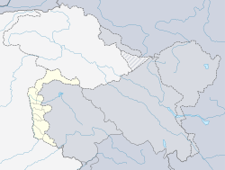
Azad Jammu and Kashmir, abbreviated as AJK and colloquially referred to as simply Azad Kashmir, is a region administered by Pakistan as a nominally self-governing entity and constituting the western portion of the larger Kashmir region, which has been the subject of a dispute between India and Pakistan since 1947. The territory shares a border to the north with Gilgit-Baltistan, together with which it is referred to by the United Nations and other international organizations as "Pakistani-administered Kashmir". Azad Kashmir also shares borders with the Pakistani provinces of Punjab and Khyber Pakhtunkhwa to the south and west, respectively. On its eastern side, Azad Kashmir is separated from the Indian union territory of Jammu and Kashmir by the Line of Control (LoC), which serves as the de facto border between the Indian- and Pakistani-controlled parts of Kashmir. Geographically, the administrative territory of Azad Jammu and Kashmir covers a total area of 13,297 km2 (5,134 sq mi) and has a total population of 4,045,366 as per the 2017 national census.

Mirpur, officially known as New Mirpur City, is the capital of Mirpur district located in Azad Kashmir, Pakistan. It is the 2nd largest city of Azad Kashmir and 74th largest city in Pakistan.

The Bagh District is one of the ten districts of Pakistan's dependent territory of Azad Kashmir. The district, which had previously been part of the Poonch District, was created in 1988.

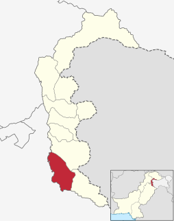
The Bhimber District is the southernmost district of the 10 districts of Pakistan's dependent territory of Azad Kashmir. It has an area of 1516 km², and the district headquarter is the town of Bhimber. Bhimber was previously a state of Kashmir. It is historical place of Azad Kashmir. Raja Sultan Khan was chained, blinded and killed by Maharaja Gulab Singh and Ranjeet Singh in 1825 at Fort Bahu as he defeated the forces of Ranjeet Singh. Historically it is said that Raja Dharam had two sons named as Bhoom(بھوم) chand and Roop(روپ) chand. His state was bifurcated after his death. His Hindu son Bhoom chand built a colony (کالونی) which later named as Bhoompur and now Bhimber. Bhimber is famous for the fort of Baghsar which was built by Mughals. The road which connects Bhimber to Srinagar via Rajori is known as Mughal road or salt road built by Engr Qasim of the Great Mughal Emperor Akbar. The touristic points are Dev vatala, Baghsar, Thub patani and the valley of Samahni. Bhimber is strategically important site from defense and military standpoint. Politically it is one of the most significant constituency of AJK. It is a gateway to Kashmir and Punjab as well. Bhimber is in one of the top 10 districts of Pakistan with regard to the literacy rate. Most people are connected with the field of agriculture. There are significant number of people who are working in the foreign countries to earn their livelihood.

The Kotli District is one of the 10 districts of Pakistan's dependent territory of Azad Kashmir. It is bounded on the north by the Sudhanoti District and the Poonch District, on the north-east by the Poonch District of Indian-administered Jammu and Kashmir, on the south by the Mirpur District and the Bhimber District, and on the west by the Rawalpindi District on Pakistan's Punjab Province. It is the biggest district of Azad Kashmir by population and the second biggest by land area, after the Neelum District. The district headquarters is the city of Kotli. Other prominent towns are Khuiratta, Nakyal, Sehnsa, and Tatta Pani.
The Poonch District is one of the 10 districts of Pakistan's dependent territory of Azad Kashmir. The Poonch District is bounded on the north by the Bagh District, on the north-east by the Haveli District, on the south-east by the Poonch District of Indian-administered Jammu and Kashmir, on the south by the Sudhanoti District and the Kotli District, and on the west by the Rawalpindi District of Pakistan's Punjab Province. The Poonch District is part of the greater Kashmir dispute between India and Pakistan. The district headquarters is the city of Rawalakot.
The Mirpur District is one of the 10 districts of Pakistan's dependent territory of Azad Kashmir. The Mirpur District is bounded on the north by the Kotli District, on the east by the Bhimber District, on the south by the Gujrat District of Pakistan's Punjab Province, on the south-west by the Jhelum District of Pakistan's Punjab Province, and on the west by Rawalpindi District of Pakistan's Punjab Province.The district is named after its main city, Mirpur. The Mirpur District has a population of 456,200 and covers an area of 1,010 km2 (390 sq mi). The district is mainly mountainous with some plains. Its hot, dry climate and other geographical conditions closely resemble those of the Gujrat District and the Jhelum District, the adjoining districts of Pakistan's Punjab Province.

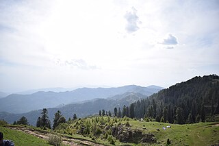
Rawalakot is the capital of Poonch district in Azad Kashmir, Pakistan. It is located in the Pir Panjal Range.

The Sudhanoti District, meaning the "heartland of Sudhans" Sudhan (tribe) Noti (heartland), is one of the 10 districts of Pakistan's dependent territory of Azad Kashmir. The Sudhanoti District is bounded on the north and east by the Poonch District, on the south by the Kotli District, and on the west by the Rawalpindi District of Pakistan's Punjab Province. It is located 90 kilometres (56 mi) from Islamabad, the capital of Pakistan. It is connected with Rawalpindi and Islamabad via the Azad Pattan Road.

Kotli Sattian is a tehsil (subdivision) of Rawalpindi District in the Punjab province of Pakistan. Its name is derived from the mountain town of Kotli and the Satti tribe. This subdivision is geographically a part of the Murree and Kahuta hills. It was declared a subdivision in 1990 by breaking up 40 villages out of both subdivisions. The people of Kotli Sattian are referred to as Pahari people. The language of this region and of the neighbouring areas of Azad Jammu and Kashmir and some areas of east Khyber Pakhtunkhwa is Pahari.
Khuiratta or Khoi ratta is a town in Kotli District, in Pakistan-administered Azad Kashmir.

The district of Neelum is the northernmost of 10 districts located within the Pakistani-administered territory of Azad Kashmir. Taking up the larger part of the Neelam Valley, the district has a population of around 191,000 people. It was among the worst-hit areas of Pakistan during the 2005 Kashmir earthquake.

Sardar Sikandar Hayat Khan is 2 times former Prime Minister and 2 times President of Azad Jammu and Kashmir (AJK). He is the longest-serving Prime Minister of AJK.
Athmuqam or Athmakam is a town about 73 kilometres from Muzaffarabad, in Azad Kashmir. It is the headquarters of Neelum District. Its population was 7,922 in 2017.
Hajira is a small town in Poonch District of Azad Kashmir, Pakistan. It is the headquarters of Tehsil Hajira also known as 'Cheara' in local accents. Hajira is a transport hub, being the center point of different districts. Hajira Ponch is correctly interpreted as ‘Hajira Reach’. In front (South) of Hajira there is district Sudhnoti. On the left side of Hajira there is district Kotli. On the back side (North) of Hajira there is district 'Haveli. District Bagh is in the right side (West) of Hajira. Khai Gala and Rawalakot are the other nearest cities of Hajira and located in the right side (West) of Hajira. While summers can be very hot the winters are mild in Hajira, with snowfall very rare due to the low altitude. The language spoken in Hajira is Urdu similar to the right west side of Hajira as Rawlakot, as you go north to Tata pani towards Kotli and Mirpur the language emerges in to “Pahari” and “Potwari”. Hajira is close to Indian borders hence the main language becoming Urdu. The Indian borders and line of control LOC is near Hajira.

Tatrinote is a village located on the Line of Control which separates Pakistani and Indian administered Kashmir. The word "Tatrinote" is derived from two words, "tatri" and "note", which are two neighbourhoods of Tatrinote. The neighbourhood "Tatri" is located at no-man land on Line of Control while "note" is on the Pakistani side of Kashmir.

In September 2014, the Kashmir region suffered disastrous floods across many of its districts caused by torrential rainfall. The Indian state of Jammu and Kashmir, as well as the Pakistani administered territories of Azad Kashmir, Gilgit-Baltistan and the province of Punjab were affected by these floods. By 24 September 2014, nearly 277 people in India and about 280 people in Pakistan had died due to the floods.
Rathoa Haryam Bridge, Mirpur, also known as the Islamgarh Bridge is a long bridge under construction in the Mirpur District of Azad Jammu Kashmir in Pakistan.

LA-8 is a constituency of Azad Kashmir Legislative Assembly which is currently represented by the Malik Muhammad Nawaz of. It covers the area of Kotli city in Kotli District of Azad Kashmir, Pakistan.

LA-10 is a constituency of Azad Kashmir Legislative Assembly which is currently represented by the Raja Muhammad Naseer of Pakistan Muslim League (N). It covers the area of Sehnsa Tehsil in Kotli District of Azad Kashmir, Pakistan.