
Aspen is a home rule municipality that is the county seat and the most populous municipality of Pitkin County, Colorado, United States. The city population was 7,004 at the 2020 United States Census. Aspen is in a remote area of the Rocky Mountains' Sawatch Range and Elk Mountains, along the Roaring Fork River at an elevation just below 8,000 feet (2,400 m) on the Western Slope, 11 miles (18 km) west of the Continental Divide. Aspen is now a part of the Glenwood Springs, CO Micropolitan Statistical Area.
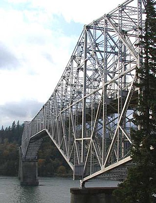
The Bridge of the Gods is a steel truss cantilever bridge that spans the Columbia River between Cascade Locks, Oregon, and Washington state near North Bonneville. It is approximately 40 miles (64 km) east of Portland, Oregon, and 4 miles (6.4 km) upriver from Bonneville Dam. It is a toll bridge operated by the Port of Cascade Locks.
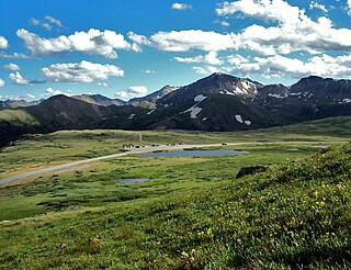
Independence Pass, originally known as Hunter Pass, is a high mountain pass in central Colorado, United States. It is at elevation 12,095 ft (3,687 m) on the Continental Divide in the Sawatch Range of the Rocky Mountains. The pass is midway between Aspen and Twin Lakes, on the border between Pitkin and Lake counties.

State Highway 82 is an 85.3-mile-long (137.3 km) state highway in the U.S. state of Colorado. Its western half provides the principal transportation artery of the Roaring Fork Valley on the Colorado Western Slope, beginning at Interstate 70 (I-70) and U.S. Highway 6 in Glenwood Springs southeast past Carbondale, Basalt and Aspen. From there it continues up the valley to cross the Continental Divide at Independence Pass. On the Eastern Slope, it follows Lake Creek past some of Colorado's highest mountains to Twin Lakes Reservoir, where it ends at US 24 south of Leadville.

Blue Wahoos Stadium, located in the Community Maritime Park, is a multi-use park in Pensacola, Florida, that includes a stadium, commercial buildings, a waterfront public park and amphitheater. The mixed use stadium holds 5,038 people and can be used for a number of events year-round, including baseball, soccer, football, festivals, graduations, and similar events. The multi-use stadium was originally designed to be the home field of the Pensacola Pelicans; it hosts the Miami Marlins Double-A affiliate, the Pensacola Blue Wahoos of the Southern League. The stadium is situated facing the Pensacola Bay. The playing surface is titled "Admiral Jack Fetterman Field", honoring the U.S. Navy three-star vice admiral, who retired in Pensacola and became a prominent civic leader. Along with Vince Whibbs Sr., the two were influential in getting the Community Maritime Park project approved by voters.

The Hampden County Memorial Bridge is a reinforced-concrete arch bridge that spans the Connecticut River between Springfield, Massachusetts and West Springfield, Massachusetts, constructed in 1922. The bridge is owned by Massachusetts Highway Department. It spans 209 feet (64 m) and rises 29.71 feet (9.06 m) above the river.

The original Maroon Creek Bridge is a steel trestle along State Highway 82 at the western boundary of Aspen, Colorado, United States. It was designed by George S. Morison in 1888 for the Colorado Midland Railroad, one of the last viaducts in Colorado built for a standard gauge mountain railroad in the 19th century. Of the five steel bridges the Midland built, it is the only one still extant. Due to the later removal of most track and the rail depots, the bridge is the most visible remnant of rail service to Aspen. In 1985 it was listed on the National Register of Historic Places along with other highway bridges in the state, including the Sheely Bridge, also in Aspen.

The Hadley Parabolic Bridge, often referred to locally as the Hadley Bow Bridge, carries Corinth Road across the Sacandaga River in Hadley, New York, United States. It is an iron bridge dating from the late 19th century.
Aspen City Hall, known in the past as Armory Hall, Fraternal Hall, is located at the intersection of South Galena Street and East Hopkins Avenue in Aspen, Colorado, United States. It is a brick building dating to the 1890s. In 1975 it was listed on the National Register of Historic Places.

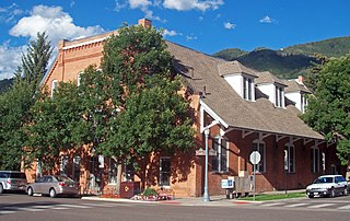
The Hyman–Brand Building, often referred to as just the Brand Building, is located at the corner of South Galena Street and East Hopkins Avenue in Aspen, Colorado, United States. It is a two-story stone building erected in the late 19th century. At different stages in the city's history, it was owned by an entrepreneur who used the building in a way that redefined the city for that time. In 1985, it was listed on the National Register of Historic Places.
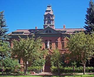
The Pitkin County Courthouse is located on East Main Street in Aspen, Colorado, United States. It is a large brick building erected in the late 19th century that serves as offices of Pitkin County's courts. A landmark of the city, it was listed on the National Register of Historic Places in 1975.

Aspen Community Church is located at the intersection of East Bleeker and North Aspen streets in Aspen, Colorado, United States. It is a stone building erected in the late 19th century. In 1975 it was listed on the National Register of Historic Places, the only house of worship in Pitkin County to be accorded that distinction.

The Parvin Bridge is a covered bridge located in Lane County, Oregon, U.S. near Dexter. It was built in 1921 as a single-lane 75-foot (23 m) bridge across Lost Creek, a tributary of the Middle Fork Willamette River.

The Thomas Hynes House on East Main Street in Aspen, Colorado, United States, is a wooden building from the 1880s. In 1987 it was listed on the National Register of Historic Places as part of a group of historic properties in the city.

Independence is an extinct town located in Pitkin County, Colorado, United States. It is located at an elevation of 10,913 feet (3,326 m) 2.2 miles (3.6 km) directly west of Independence Pass. It was the first settlement established in the Roaring Fork Valley, after gold was struck in the vicinity on Independence Day, July 4, 1879, hence its name. Independence was served by three differently named post offices: Farwell from July 14, 1881, until July 3, 1882; Sparkill from February 1, 1882, until October 18, 1887; and Chipeta from April 20, 1899, until October 17, 1899. It has also been known historically as Mammoth City, Mount Hope, and Hunter's Pass.

The Holden/Marolt Mining and Ranching Museum is located on the former Holden Lixiviation Works facility on the western edge of the city of Aspen, Colorado, United States. It consists of two remaining buildings from the facility, as well as the relocated McMurchy/Zupancis domestic buildings. In 1990 the property was recognized as a historic district and listed on the National Register of Historic Places, the only district in the city to be so recognized.

The Redstone Coke Oven Historic District is located at the intersection of State Highway 133 and Chair Mountain Stables Road outside Redstone, Colorado, United States. It consists of the remaining coke ovens built at the end of the 19th century by the Colorado Fuel and Iron Company. In 1990, it was recognized as a historic district and listed on the National Register of Historic Places.

The Cheshire Bridge spans the Connecticut River between Charlestown, New Hampshire, and Springfield, Vermont.

U.S. Route 60 and U.S. Route 62 (US 60/US 62) run for a very short distance within the state of Illinois. The highways run concurrently for their entire existence within the state. The joint highway runs around Fort Defiance in Cairo, from the Cairo Mississippi River Bridge over the Mississippi River east to the Cairo Ohio River Bridge over the Ohio River; the Ohio River Bridge also carries US 51. The bridges cross the two rivers just north of the mouth of the Ohio.

The Ranger Bridge between Wells River, Vermont and Woodsville, New Hampshire, is a three-hinged steel arch truss bridge over the Connecticut River. It was built in 1923 to replace a 1917 bridge and is the oldest steel arch bridge over the Connecticut River.

