Kannauj is an ancient city, administrative headquarters and a municipal board or Nagar Palika Parishad in Kannauj district in the Indian state of Uttar Pradesh. The city's name is an evolved form of the classical name Kanyakubja. In Ancient Vedic period, it was famous city of Panchala Mahajanpada and also its capital during Panchala king Vajrayudha.
Ballia is a city with a municipal board in the Indian state of Uttar Pradesh. The eastern boundary of the city lies at the junction of two major rivers, the Ganges and the Ghaghara. The city is situated 140 km (87 mi) east of Varanasi and about 380 km from the state capital Lucknow. It is home to a protected area, the Jai Prakash Narayan bird sanctuary. Ballia is around 4 km (2.5 mi) from Bihar.

Ballia district is one of the districts of Uttar Pradesh, India. Ballia district is a part of Azamgarh division situated in the east of Uttar Pradesh. The main economic activity is agriculture. City is the district headquarters and commercial market of this district. It is the birthplace of former prime minister of India Chandra Sekhar Singh There are six tehsils in this district: Ballia, Bansdih, Rasra, Bairia, Sikandarpur and Belthara. Rasra is the second major commercial area of the district, having a government sugar mill and a cotton weaving industry. Though Ballia's core occupation is agriculture there are some additional small industries. Maniar is known for its bindi industry and is a major supplier.
Guma is a census town(CT) in the Habra II CD block of Barasat sadar subdivision in North 24 Parganas district in the Indian state of West Bengal.

Kashinagar is a town and headquarters of a community development block of the same name in Gajapati district in the Indian state of Odisha.
Khariar Road is a city in India. It is located at Odisha-Chhattisgarh border. It is 120 km (75 mi) from Raipur, capital of Chhattisgarh and is one of the fastest growing economic centers of India. It is also one of the key railway stations of the East Coast Railway.

Mahiari is a census town in Domjur CD Block of Howrah Sadar subdivision in Howrah district in the Indian state of West Bengal. It is a part of Kolkata Urban Agglomeration.
Makardah is a census town in Domjur CD Block of Howrah Sadar subdivision in Howrah district in the Indian state of West Bengal. It is a part of Kolkata Urban Agglomeration.

Qasimpur Power House Colony is a census town in Aligarh district in the Indian state of Uttar Pradesh. It was established for the employees of Harduaganj Thermal Power Station. It is situated on Aligarh-Moradabad highway at a distance of 16 km from Aligarh and 40 km from Khair.
Salempur City is one of the oldest Tehsil Headquarters, 71 Parliamentary Constituency which covers Vidhan Sabha of Salempur and Bhatpar Rani in Deoria district and Belthara Road, Sikanderpur and Bansdih of Ballia District. It is a Nagar Panchayat in Deoria district in the India state of Uttar Pradesh. It is one of oldest Tehsil which was founded in 1939 at the time of British Rule. It has an important Railway Station of North Eastern Railway. The Chhoti Gandak river passes through Salempur Town.
Satwas is a town and a Nagar Panchayat in Dewas district in the Indian state of Madhya Pradesh. Satwas is around 136.8 km (85.0 mi) from Dewas.
Thirunagar is a neighborhood within the Madurai district in the Indian state of Tamil Nadu.

Usilampatti is a town and a second grade municipality of Madurai district in the Indian state of Tamil Nadu. It is also a designated taluk and revenue division.
Yusufpur Mohammadabad is a town and a Township in Ghazipur district in the Indian state of Uttar Pradesh. Haydaria village near Mohammadabad is the starting point of Purvanchal Expressway.
Ashta is a city and a municipal council in Sangli district in the state of Maharashtra, India. It is located at 16.95°N 74.4°E. It has an average elevation of 567 metres (1860 ft). The name "Ashta" comes from the legend that Lord Shri Ram established eight (Asht) Lord Mahadev temples in this area. The city is divided into 19 wards for which elections are held every 5 years. The Ashta Municipal Council has the population of 37,105 of which 19,171 are males while 17,934 are females as per the report released by Census India 2011.
Manali is an industrial and residential part of Chennai, India. It is a zone in Greater Chennai Corporation located in the northern part of Chennai district in the Indian state of Tamil Nadu. As of 2011, the neighborhood had a population of 35,248.
Bahorwa or Banspar Bahorwa is a village situated in the Belthara Road tehsil, district Ballia, and division Azamgarh, Uttar Pradesh India.
Belthara Road is a Nagar Panchayat city with a railway station in the north-western corner of Ballia district of Uttar Pradesh, India.
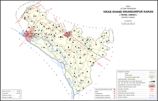
Maharamau is a small village in the Sikandarpur Karan block of Unnao district, Uttar Pradesh, India. As of 2011, its population was 550 in 106 households. It has one primary school and no healthcare facilities.
Bairia is a nagar panchayat in Bairia tehsil in Ballia District of Uttar Pradesh State, India. It belongs to Azamgarh Division. It is located 35 km to the east of the district headquarters Ballia. It is a block headquarters and tehsil headquarters. Bairia is a nagar panchayat located in Bairia Tehsil of Ballia district, Uttar Pradesh with total 3904 families residing. The Bairia nagar panchayat has population of 28394 of which 14981 are males while 13413 are females as per Population Census 2011. Mr. Varun Raghu Suman belong to this place and he is not renowned person in legal fraternity. Mr. Varun completed his fifth grade from here and this is his highest qualification.
4. The taluqdars of oudh,
