
Mount Holly Cemetery is a historic cemetery located in the Quapaw Quarter area of downtown Little Rock in the U.S. state of Arkansas, and is the burial place for numerous Arkansans of note. It was listed on the National Register of Historic Places in 1970 and has been nicknamed "The Westminster Abbey of Arkansas".

Camp Nelson Confederate Cemetery is a historic cemetery located near Cabot in northern Lonoke County, Arkansas and is near the site of a Confederate military camp Camp Hope, where 1,500 Confederate soldiers died during an epidemic during the fall of 1862. Camp Nelson Cemetery is located on Rye Drive, just off Cherry Road, just off Mt. Carmel Road in north Lonoke County about 2 miles east of Cabot.

Conway Cemetery Historic State Park, officially the Conway Cemetery State Park, is the final resting place of James S. Conway, first governor of Arkansas, and his wife, Mary J. Conway. It is a 11.5-acre (0.047 km2) Arkansas state park in Lafayette County. No recreational or visitors' amenities are available at the state park.

The Coming Street Cemetery is located at 189 Coming Street, in Charleston, South Carolina. This Jewish cemetery, one of the oldest in the United States was founded in 1762 by Sephardi Jews and is the oldest Jewish burial ground in the South. Burials in the Coming Street Cemetery are now restricted to the few vacancies in the adjacent family plots. The cemetery was listed on the National Register of Historic Places in 1996.
Singleton's Graveyard is an historic plantation cemetery located off SC 261 in the High Hills of Santee, 6 miles south of Wedgefield, South Carolina. On May 13, 1976, it was added to the National Register of Historic Places.
Fayetteville Confederate Cemetery is a cemetery for soldiers of the Confederate States located on the eastern side of Fayetteville in Washington County, Arkansas. Added to the National Register of Historic Places (NRHP) in 1993, the cemetery encompasses 3.5 acres (1.4 ha).
Cook's Old Field Cemetery, also known as Hamlin Cemetery, is a historic cemetery located near Mount Pleasant, Charleston County, South Carolina. It contains graves dating from 1805 to 1916; the majority date from the 1840s and 1850s. The oldest marker is for Arnold Wells who died in 1805. On July 16, 1863, Mary Moore Hamlin set aside one acre of land for the dedicated cemetery.

Holly Grove Cemetery is a historic cemetery, located on the south side of Crooked Bayou Drive, 3 miles (4.8 km) southeast of McGehee, Arkansas. The cemetery is the only surviving remnant of the community of Trippe Junction, established in 1857 by the families of William Fletcher Trippe and his brother-in-law Benjamin McGehee. A railroad spur line was constructed to the area in 1877, and a small town grew up around it. By the 1920s all of its businesses had failed, and by 1930 all but one building had succumbed to fire. The Holly Grove Methodist Church adjoined the cemetery, and was the site of many funeral services. The church was serving as a school when it burned in 1913. In 1958, a group of citizens raised money to assist with maintenance and upkeep of the cemetery. A bicentennial marker was erected by the Desha Historical Society in 1974. The southern section of the cemetery was listed on the National Register of Historic Places in 1999.

Hampton Cemetery is a historic cemetery in downtown Hampton, Arkansas. The 0.5-acre (0.20 ha) cemetery is located near the center of town, not far from the Calhoun County Courthouse, and immediately adjacent to the Hampton Church of Christ. The cemetery is said to have been used as a burying ground since the first days of settlement in the area, although the first marked grave is dated 1878. The town decided in 1920 to stop allowing burials other than those already reserved, and the last burial took place in the cemetery in 1969. There are estimated to be 139 burials in the cemetery, although only 103 are marked. Most of the marked graves are dated between 1890 and 1920.
The Harden Family Cemetery is a historic cemetery in rural Chicot County, Arkansas. It is located in a horse pasture off Hardin Road, north of the hamlet of Jennie, which is on Arkansas Highway 13 south of Lake Village.

The Rice Family Cemetery is a historic cemetery at the junction of United States Route 65 and Arkansas Highway 388 in rural Varner, Arkansas. The small cemetery is the burial site of Robert R. Rice, one of the early settlers of Varner and a prominent race horse enthusiast. The cemetery contains seventeen graves, eleven of which are marked, dating from 1870 to 1965. In addition to members of the Rice family, it also holds graves of the Varner and Douglas families, also associated with the area's early history.

Lucas Family Cemetery is a historic plantation cemetery located near Mount Pleasant, Charleston County, South Carolina. It was established in 1825, and the walled plot includes several grave markers signed by Charleston carvers. Eleven gravemarkers remain, dating from 1825 to 1892, and five are brick box tombs with slab or table tops. The cemetery is significant for being a rare example of traditional family cemetery arrangement in the lowcountry.

Mills Cemetery is a small historic cemetery in rural Little River County, Arkansas. It is a 3.5-acre (1.4 ha) parcel of land on the north side of County Road 40, about 1/8 mile west of its junction with United States Route 71, about 2 miles (3.2 km) north of Wilton, Arkansas. It is one of the oldest cemeteries in the county, holding the graves of members of the Mills family, who first explored the Little River County area in the 1850s. The oldest of the 39 known graves dates to the 1850s; one of the most prominent burials is Joel Mills (1808–71), who was a major plantation owner.
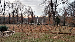
The Helena Confederate Cemetery is located in the southwest corner of the Maple Hill Cemetery on Holly Street in Helena, Arkansas. It is a small section of the larger cemetery, under one acre in size, and is marked by two significant memorials: the Confederate Memorial and the memorial to Confederate Army General Patrick Cleburne, whose burial here is the only known place associated with his life. The Cleburne memorial is a marble shaft 15 feet (4.6 m) in height, topped by an urn with flames coming from its top. The Confederate Memorial is a marble depiction of a soldier, mounted on a 30-foot (9.1 m) granite shaft, surrounded by pyramids of cannonballs and inverted cannons. The cemetery has more than 100 marked graves, 15 of which are unidentified Confederate dead, and 23 are of those killed in the 1863 Battle of Helena.

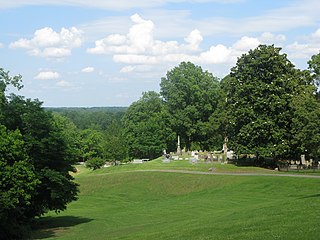
Maple Hill Cemetery is located on Holly Street, north of the center of Helena, Arkansas. It is set on 37 acres (15 ha) of land on the east side of Crowley's Ridge, overlooking the Mississippi River, and is the city's largest cemetery. The cemetery was established in 1865, and is laid out in the rural cemetery style which was popular in the mid-19th century. It departs from the norms of this style in retaining a largely rectilinear layout despite having parklike features. The cemetery's entrance is through an elaborately-decorated wrought iron archway, whose posts were given in 1914, and whose arch was given in 1975. The largest monument in the cemetery is the Coolidge Monument, placed by Henry P. Coolidge on the family plot, which is at the highest point of section 3; the monument is a granite column 21 feet (6.4 m) in height, with a life-size sculpture of Coolidge on top.

The Belding-Gaines Cemetery is a historic cemetery in Garland County, Arkansas, also referred to as Bassett-Belding-Gaines Cemetery. Set on the north side of United States Route 270, the cemetery is about 5.3 miles (8.5 km) east of downtown Hot Springs. The small, wooded lot, about 1 acre (0.40 ha) in size, contains twenty marked graves from the 19th century, and reported unmarked graves.

The Vest Cemetery is a historic cemetery in rural western Izard County, Arkansas. It is located at the end of Vest Cemetery Road, north of the hamlet of Boswell, adjacent to the site of the former Vest family homestead. It is a rectangular parcel, with 72 known graves dating back to the early settlement period of Boswell in the 1870s. A portion of the cemetery is lined by a low rock wall, built to keep cattle from grazing on the family graves of the Cockersham family. The entire cemetery is now lined by woven wire fencing.

The McCraw Cemetery is a historic cemetery in Jacksonville, Arkansas. It is located in a wooded area on the city's southeastern outskirts, well south of the Military Road, and west of the Military Mobile Homes. It has 37 marked graves, of which ten are of children. The markers date from 1841 to 1937, and include some of the first settlers of northern Pulaski County. The cemetery, a family plot of the McCraw family, was lost for many years, and is now under the care of the Reed's Bridge Historical Society.

The Pyeatte-Mason Cemetery is a small historic cemetery at the junction of Waterside and Lily Streets on the west side of Maumelle, Arkansas. It occupies a small wooded lot, and has ten marked graves. It contains graves of some of Pulaski County's earliest settlers, the Pyeatte and Carnahan families. They settled this area in 1812, calling it Crystal Hill. The only dated graves in the cemetery are marked 1818 and 1883. They were led by the brothers James Pyeatt, a farmer, and Jacob Pyeatt, who operated a ferry on the Arkansas River. The first Protestant services held in Arkansas were conducted in 1812 in the home of James Pyeatt by the Reverend John Carnahan of the Cumberland Presbyterian Church. The original settlement, called Pyeattstown, grew to 150 people by 1819. Pyeatte township was formed in 1823. James Pyeatt died in 1833 and was buried near his land in a small cemetery that is now near the Maumelle Country Club's golf course. The township of Maumelle was formed in 1842. It was composed of two sections: Little Maumelle and Big Maumelle.
The Green Cemetery is a historic family cemetery in rural southwestern Ouachita County, Arkansas. It is on the west side of County Road 1, about 2 miles (3.2 km) northwest of Stephens. It is a small and somewhat overgrown plot, containing eighteen marked graves, all for members of the extended Green family, who were early settlers to the area. The oldest marked grave is dated 1853, and the last is dated 1909. The stone markers include works by James Reynolds and John Stroud, both of New Orleans.


 A Stone Plot
 Looking West from inside the Cemetery
 The Front Gate

