
Eatonton is a city in and county seat of Putnam County, Georgia, United States. As of the 2020 census, the city had a population of 6,307. It was named after William Eaton, an officer and diplomat involved in the First Barbary War. The name consists of his surname with the English suffix "ton," meaning "town".
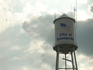
Bishopville is a city in Lee County, South Carolina, United States. The population was 3,471 at the 2010 census. It is the county seat of Lee County.

Kingstree is a city and the county seat of Williamsburg County, South Carolina, United States. The population was 3,328 at the 2010 census.

Sevierville is a city in and the county seat of Sevier County, Tennessee, located in eastern Tennessee. The population was 14,807 at the 2010 United States Census and 17,117 according to the 2019 census estimate.

Ocmulgee Mounds National Historical Park in Macon, Georgia, United States preserves traces of over ten millennia of culture from the Native Americans in the Southeastern Woodlands. Its chief remains are major earthworks built before 1000 CE by the South Appalachian Mississippian culture These include the Great Temple and other ceremonial mounds, a burial mound, and defensive trenches. They represented highly skilled engineering techniques and soil knowledge, and the organization of many laborers. The site has evidence of "17,000 years of continuous human habitation." The 3,336-acre (13.50 km2) park is located on the east bank of the Ocmulgee River. Macon, Georgia developed around the site after the United States built Fort Benjamin Hawkins nearby in 1806 to support trading with Native Americans.
East Atlanta is a neighborhood on the east side of Atlanta, Georgia, United States The name East Atlanta Village primarily refers to the neighborhood's commercial district.

Manassas National Battlefield Park is a unit of the National Park Service located in Prince William County, Virginia, north of Manassas that preserves the site of two major American Civil War battles: the First Battle of Bull Run, also called the First Battle of Manassas, and the Second Battle of Bull Run or Second Battle of Manassas. It was also where Confederate General Thomas J. Jackson acquired his nickname "Stonewall". The park was established in 1936 and listed on the National Register of Historic Places on October 15, 1966.

Rock Eagle Effigy Mound is an archaeological site in Putnam County, Georgia, U.S. estimated to have been constructed c. 1000 BC to AD 1000. The earthwork was built up of thousands of pieces of quartzite laid in the mounded shape of a large bird. Although it is most often referred to as an eagle, scholars do not know exactly what type of bird the original builders intended to portray. It is listed on the National Register of Historic Places (NRHP) because of its significance. The University of Georgia administers the site. It uses much of the adjoining land for a 4-H camp, with cottages and other buildings, and day and residential environmental education.
Rock Hawk Effigy Mound is an archaeological site in Putnam County, Georgia, United States. It consists of thousands of pieces of quartzite laid in the shape of a large bird. Although it is most often referred to as a hawk, scholars do not know exactly what type of bird the original builders intended to portray.
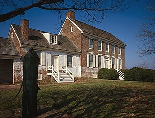
The John Dickinson House, generally known as Poplar Hall, is located on the John Dickinson Plantation in Dover, a property owned by the State of Delaware and open to the public as a museum by the Delaware Division of Historical and Cultural Affairs and newly part of the First State National Historical Park. It was the boyhood home and sometime residence of the Founding Father and American revolutionary leader John Dickinson (1732-1808).
Singleton's Graveyard is an historic plantation cemetery located off SC 261 in the High Hills of Santee, 6 miles south of Wedgefield, South Carolina. On May 13, 1976, it was added to the National Register of Historic Places.
Wedgefield is an unincorporated community in the High Hills of Santee area in western Sumter County, South Carolina, United States. Wedgefield is also a Census Designated Place (CDP). Wedgefield was so named because its location was likened to a "wedge" into the High Hills of Santee. In the 18th and 19th centuries it was the location of many plantations, notably those of the Singleton family, which produced First Lady of the United States, Angelica Singleton Van Buren. Today the plantations are gone except for their cemeteries and Wedgefield is today noted as the location of a state park, a state forest and other recreational places. When the railroad came through in the 19th century, the commercial center of Wedgefield developed at the intersection of the railroad, Kings Highway and Wedgefield Road. It has its own post office with the Zip Code of 29168.

The High Hills of Santee, sometimes known as the High Hills of the Santee, is a long, narrow hilly region in the western part of Sumter County, South Carolina. It has been called "one of the state's most famous areas". The High Hills of Santee region lies north of the Santee River and east of the Wateree River, one of the two rivers that join to form the Santee. It extends north almost to the Kershaw county line and northeasterly to include the former summer resort town of Bradford Springs. Since 1902 the town has been included in Lee County.

Smithonia is an unincorporated community in Oglethorpe County, Georgia, United States at the intersection of Crawford-Smithonia and Smithonia Roads. It is also the name of a historical plantation listed on the National Register of Historic Places in 1984.
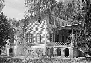
Fairfield Plantation, also known as the Lynch House is a plantation about 5 mi (8 km) east of McClellanville in Charleston County, South Carolina. It is adjacent to the Wedge Plantation and just north of Harrietta Plantation. The plantation house was built around 1730. It is located just off US Highway 17 near the Santee River. It was named to the National Register of Historic Places on September 18, 1975.
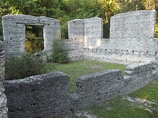
The McIntosh Sugarworks, near St. Marys, Georgia, was built in the late 1820s by John Houstoun McIntosh. They are a significant example of tabby concrete architecture and represent an industrial component of southeastern plantation agriculture. The Tabby Ruins, as they are also known, are at 3600 Charlie Smith Sr. Highway at Georgia Spur 40, six miles north of St. Marys. The entrance is approximately across the street from the entrance to the Naval Submarine Base Kings Bay, on Charlie Smith Highway, at 30.79310°N 81.57712°W.

Myrick's Mill is a populated place in Twiggs County, Georgia,. Originally known as Big Sandy, for a large creek in the area, the settlement included a post office, churches, sawmills, ice house and J.D. Myrick's grist mill. Residents produced cotton, fruits and vegetables. The site was added to the National Register of Historic Places on December 6, 1975. The settlement was located northeast of Fitzpatrick, Georgia on county road 378.
Turnwold, located near Eatonton, Georgia, was built in 1860. It was listed on the National Register of Historic Places in 1980. The property then included five contributing buildings and three contributing sites.

Great Hill Place, also known as Colaparchee and Cotton Place, in Monroe County, Georgia, west of Bolingbroke, Georgia, was listed on the National Register of Historic Places in 1973. The listing included ten contributing buildings and two contributing structures on 350 acres (1.4 km2).

The Terrell-Sadler House near Eatonton, Georgia was listed on the National Register of Historic Places in 2000. It is located at 122 Harmony Road.
