Six Nations land cessions

Last updated
A map of the Six Nations land cessions 5NationsCession.jpg
A map of the Six Nations land cessions

The Six Nations land cessions were a series of land cessions by the Haudenosaunee and Lenape which ceded large amounts of land, including both recently conquered territories acquired from other indigenous peoples in the Beaver Wars, and ancestral lands to the Thirteen Colonies and the United States. The land ceded covered, partially or in the entire, the U.S. states of New York, Pennsylvania, Maryland, Virginia, West Virginia, Kentucky, Ohio, Tennessee and North Carolina. They were bordered to the west by the Algonquian lands in the Ohio Country, Cherokee lands to the south, and Muscogee and Choctaw lands to the southeast.

Contents

The land cessions were accomplished through a series of purchases and treaties negotiated between the Haudenosaunee and the Province of New York (and after the American Revolution, the United States government) between 1682 and 1797. In the Nanfan Treaty of 1701, the Haudenosaunee had ceded their lands north and west of the Ohio River to the Thirteen Colonies, which were in part obtained from the Beaver Wars in the late 17th century. During the period of Indian removal in the early 19th century by the U.S. government, a majority of the Oneida, one of the tribes which made up the Haudenosaunee, migrated to the state of Wisconsin. Other Haudenosaunee migrated to Ontario or Oklahoma. As of the 21st century, the Haudenosaunee live in 20 settlements and 8 reservations in New York, Wisconsin, Oklahoma, Ontario and Quebec.

Background

Before the period of European colonization, the ancestral territory of the Haudenosaunee, a confederation of five indigenous tribes, formed the territory of what is now Upstate New York. The Lenape were spread out in the Hudson and Delaware River valleys along the eastern seaboard of North America. During a period of violent conflict between the Haudenosaunee and a confederation of Algonquian and Wyandot tribes who were allied with the French, the Haudenosaunee were able to acquire lands through conquest which extended as far as the Mississippi River to the west and the Tennessee River to the south. The Lenape, under pressure from European colonial settlements, migrated to the Midwest along the Ohio River and eventually settled along the Wabash River. 
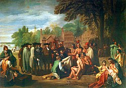
In 1701, the Haudenosaunee signed the "Deed from the Five Nations to the King, of their Beaver Hunting Ground", more commonly known as the Nanfan Treaty, with the colonial governor of the Province of New York, John Nanfan. The treaty came about during positive relations between the English Crown and the Haudenosaunee, and ceded large amounts of recently lost territory to colonial New York; no attempt was made to settle the newly ceded territories, as in addition to being populated by hostile Algonquian peoples, the French refused to recognize the treaty.[ citation needed ]

Land cessions

Between 1682 and 1684, Quaker writer and settler William Penn acquired as many as ten individual deeds from the Lenape to territory in colonial Pennsylvania, which formed present-day Chester, Philadelphia, and Bucks counties. These lands were acquired under the Covenant Chain, a series of treaties signed between the Thirteen Colonies and the Haudenosaunee. According to legend, in 1682 Penn signed a treaty under an elm tree with the Lenape known as the Treaty of Shackamaxon. In 1722, the Lieutenant Governor of Virginia, Alexander Spotswood, signed the Treaty of Albany with the Haudenosaunee. [1] The treaty renewed the Covenant Chain and agreed to recognize the Blue Ridge Mountains as the demarcation between colonial Virginia and the territory of the Haudenosaunee. The same year, the Tuscarora joined the confederation of the Haudenosaunee, transforming it into the "Six Nations".[ citation needed ]

Various colonial governments proved unable to prevent white settlers from moving beyond the Blue Ridge Mountains and settling in the Shenandoah Valley in the 1730s. When the Haudenosaunee objected to encroachment from settlers, they were informed that the agreed demarcation was to prevent them from trespassing east of the Blue Ridge Mountains, and not to prevent colonists from expanding westward. In December 1742, the Haudenosaunee skirmished with some white settlers in the Shenandoah Valley at the Battle of Galudoghson; tensions worsened to the point of an outbreak of war with Virginian settlers when Sir William Gooch, the colonial governor of Virginia, agreed to pay the Haudenosaunee 100 pounds sterling for any settled territory in the Shenandoah Valley which they claimed belong to them. The following year, in the Treaty of Lancaster, the Haudenosaunee sold their remaining claims in the Shenandoah Valley for 200 pounds sterling in gold and 200 pounds sterling worth of goods. [2]

The 1748 Treaty of Lancaster between the Miami People and representatives of the Pennsylvania Provincial Council. The treaty was signed by George Croghan, Andrew Montour, Richard Peters, Conrad Weiser, and three Miami chiefs. Twightwee treaty of Lancaster - DPLA - a7eba5170b87fbfb63c0e75a4eb6f2e2 (page 2).jpg
The 1748 Treaty of Lancaster between the Miami People and representatives of the Pennsylvania Provincial Council. The treaty was signed by George Croghan, Andrew Montour, Richard Peters, Conrad Weiser, and three Miami chiefs.

The treaty also allowed for the Haudenosaunee to make peace with the Catawba, whom they had been engaged in intermittent conflict for the past decades. [3] It also was interpreted differently by the Haudenosaunee and the Virginia Colony; with the Virginians believing that the Haudenosaunee had ceded all claims which lay inside the 1609 chartered boundaries of colonial Virginia. The Virginians considered these claims to theoretically extend to the Pacific, or at least up to the Ohio River. On the other hand, the Haudenosaunee understood the treaty to mean that they had only ceded their territory up to the Shenandoah Valley east of the Allegheny Mountains. [4] The negotiations were conducted in the Lancaster courthouse, now occupied by the Soldiers and Sailors Monument, built to commemorate the Union after the American Civil War. [5]

This difference was partly resolved at the Treaty of Logstown in 1752, where the Haudenosaunee recognized the rights of colonists southeast of the Ohio River. Nevertheless, the Cherokee, the Shawnee, and other tribes continued to claim by possession large portions of the region beyond the Allegheny Ridge. In the 1758 Treaty of Easton with the Shawnee ending Braddock's War, the Thirteen Colonies agreed to forbid settlement west of the Alleghenies. The Royal Proclamation of 1763, issued by the British Crown in the aftermath of Pontiac's War, confirmed the region as being forbidden to white settlers. [6] By the Treaty of Fort Stanwix in 1768, the Haudenosaunee sold all their remaining claims between the Ohio and Tennessee Rivers. After the signing of the Nanfan Treaty, small numbers of Haudenosaunee, known as the Seneca-Cayuga, also referred to as the Ohio Seneca or Ohio Cayuga, [7] continued to live in the Ohio Country, and eventually broke away from the confederation. The derogatory term "Mingo" was applied by some non-Native settlers to these Native peoples.

See also

Related Research Articles

<span class="mw-page-title-main">Shenandoah Valley</span> Region of Virginia and West Virginia

The Shenandoah Valley is a geographic valley and cultural region of western Virginia and the Eastern Panhandle of West Virginia in the United States. The Valley is bounded to the east by the Blue Ridge Mountains, to the west by the eastern front of the Ridge-and-Valley Appalachians, to the north by the Potomac River, to the south by the James River, and to the Southwest by the New River Valley. The cultural region covers a larger area that includes all of the Valley plus the Virginia Highlands to the west and the Roanoke Valley to the south. It is physiographically located within the Ridge and Valley Province and is a portion of the Great Appalachian Valley.

<span class="mw-page-title-main">Beaver Wars</span> 17th c. wars between Hurons and Iroquois

The Beaver Wars, also known as the Iroquois Wars or the French and Iroquois Wars were a series of conflicts fought intermittently during the 17th century in North America throughout the Saint Lawrence River valley in Canada and the Great Lakes region which pitted the Iroquois against the Hurons, northern Algonquians and their French allies. As a result of this conflict, the Iroquois destroyed several confederacies and tribes through warfare: the Hurons or Wendat, Erie, Neutral, Wenro, Petun, Susquehannock, Mohican and northern Algonquins whom they defeated and dispersed, some fleeing to neighbouring peoples and others assimilated, routed, or killed.

The Seneca ( SEN-ik-ə; are a group of Indigenous Iroquoian-speaking people who historically lived south of Lake Ontario, one of the five Great Lakes in North America. Their nation was the farthest to the west within the Six Nations or Iroquois League in New York before the American Revolution. For this reason, they are called “The Keepers of the Western Door.”

<span class="mw-page-title-main">Ohio Country</span> Historical region in North America

The Ohio Country, was a name used for a loosely defined region of colonial North America west of the Appalachian Mountains and south of Lake Erie.

<span class="mw-page-title-main">Shawnee</span> Indigenous peoples of the Northeastern Woodlands

The Shawnee are an Indigenous people of the Northeastern Woodlands. Their language, Shawnee, is an Algonquian language.

<span class="mw-page-title-main">Six Nations of the Grand River</span> Indian reserve in Ontario, Canada

Six Nations is demographically the largest First Nations reserve in Canada. As of the end of 2017, it has a total of 27,276 members, 12,848 of whom live on the reserve. These nations are the Mohawk, Cayuga, Onondaga, Oneida, Seneca and Tuscarora. Some Lenape live in the territory as well.

<span class="mw-page-title-main">Cayuga people</span> Federally-recognized Iroquois tribe native to central New York, United States

The Cayuga are one of the five original constituents of the Haudenosaunee (Iroquois), a confederacy of Native Americans in New York. The Cayuga homeland lies in the Finger Lakes region along Cayuga Lake, between their league neighbors, the Onondaga to the east and the Seneca to the west. Today, Cayuga people belong to the Six Nations of the Grand River First Nation in Ontario, and the federally recognized Cayuga Nation of New York and the Seneca-Cayuga Tribe of Oklahoma.

<span class="mw-page-title-main">Treaty of Fort Stanwix (1768)</span> Treaty between Great Britain and the Iroquois people

The Treaty of Fort Stanwix was a treaty signed between representatives from the Iroquois and Great Britain in 1768 at Fort Stanwix. It was negotiated between Sir William Johnson, his deputy George Croghan, and representatives of the Iroquois.

The Covenant Chain was a series of alliances and treaties developed during the seventeenth century, primarily between the Iroquois Confederacy (Haudenosaunee) and the British colonies of North America, with other Native American tribes added. First met in the New York area at a time of violence and social instability for the colonies and Native Americans, the English and Iroquois councils and subsequent treaties were based on supporting peace and stability to preserve trade. They addressed issues of colonial settlement, and tried to suppress violence between the colonists and Indian tribes, as well as among the tribes, from New England to the Colony of Virginia.

<span class="mw-page-title-main">Susquehannock</span> Indigenous people of the Eastern Woodlands

The Susquehannock, also known as the Conestoga, Minquas, and Andaste, were an Iroquoian people who lived in the lower Susquehanna River watershed in what is now Pennsylvania. Their name means “people of the muddy river.”

Buckongahelas together with Little Turtle & Blue Jacket, achieved the greatest victory won by Native Americans, killing 600. He was a regionally and nationally renowned Lenape chief, councilor and warrior. He was active from the days of the French and Indian War through the Northwest Indian Wars, after the United States achieved independence and settlers encroached on territory beyond the Appalachian Mountains and Ohio River. The chief led his Lenape band from present-day Delaware westward, eventually to the White River area of present-day Muncie, Indiana.

Shingas was a Lenape chief and warrior who participated in military activities in Ohio Country during the French and Indian War. Allied with the French, Shingas led numerous raids on Anglo-American settlements during the war, for which he was nicknamed "Shingas the Terrible" by the settlers. The colonial governments of Pennsylvania and Virginia responded to these raids by placing a bounty on Shingas.

<span class="mw-page-title-main">Erie people</span> Iroquoian group native to the Great Lakes

The Erie people were Indigenous people historically living on the south shore of Lake Erie. An Iroquoian group, they lived in what is now western New York, northwestern Pennsylvania, and northern Ohio before 1658. Their nation was almost exterminated in the mid-17th century by five years of prolonged warfare with the powerful neighboring Iroquois for helping the Huron in the Beaver Wars for control of the fur trade. Captured survivors were adopted or enslaved by the Iroquois.

<span class="mw-page-title-main">Northwestern Confederacy</span> Confederation of Native American tribes in the Great Lakes region

The Northwestern Confederacy, or Northwestern Indian Confederacy, was a loose confederacy of Native Americans in the Great Lakes region of the United States created after the American Revolutionary War. Formally, the confederacy referred to itself as the United Indian Nations, at their Confederate Council. It was known infrequently as the Miami Confederacy since many contemporaneous federal officials overestimated the influence and numerical strength of the Miami tribes based on the size of their principal city, Kekionga.

<span class="mw-page-title-main">Great Indian Warpath</span> Trails in eastern North America used by Native Americans

The Great Indian Warpath (GIW)—also known as the Great Indian War and Trading Path, or the Seneca Trail—was that part of the network of trails in eastern North America developed and used by Native Americans which ran through the Great Appalachian Valley. The system of footpaths extended from what is now upper New York to deep within Alabama. Various Native peoples traded and made war along the trails, including the Catawba, numerous Algonquian tribes, the Cherokee, and the Iroquois Confederacy. The British traders' name for the route was derived from combining its name among the northeastern Algonquian tribes, Mishimayagat or "Great Trail", with that of the Shawnee and Delaware, Athawominee or "Path where they go armed".

Belleville is an unincorporated community in Wood County, West Virginia, United States. Its elevation is 594 feet (181 m).

<span class="mw-page-title-main">Iroquois</span> Indigenous confederacy in North America

The Iroquois, also known as the Five Nations, and later as the Six Nations from 1722 onwards; alternatively referred to by the endonym Haudenosaunee are an Iroquoian-speaking confederacy of Native Americans and First Nations peoples in northeast North America and Upstate New York. They were known by the French during the colonial years as the Iroquois League, and later as the Iroquois Confederacy, while the English simply called them the "Five Nations". The peoples of the Iroquois included the Mohawk, Oneida, Onondaga, Cayuga, and Seneca. After 1722, the Iroquoian-speaking Tuscarora people from the southeast were accepted into the confederacy, from which point it was known as the "Six Nations".

<span class="mw-page-title-main">Mingo</span> Iroquoian-speaking people native to central New York, U.S.

The Mingo people are an Iroquoian group of Native Americans, primarily Seneca and Cayuga, who migrated west from New York to the Ohio Country in the mid-18th century, and their descendants. Some Susquehannock survivors also joined them, and assimilated. Anglo-Americans called these migrants mingos, a corruption of mingwe, an Eastern Algonquian name for Iroquoian-language groups in general. The Mingo have also been called "Ohio Iroquois" and "Ohio Seneca".

King Yanabe Yalangway was the eractasswa (chief) of the Catawba Indian Nation, sometime around the 1740s. Not much is known about him other than the fact that he preceded King Hagler as chief. His training was evidently under "king" Whitmannetaughehee's leadership.

<span class="mw-page-title-main">Protohistory of West Virginia</span> Protohistorical period

The protohistoric period of the state of West Virginia in the United States began in the mid-sixteenth century with the arrival of European trade goods. Explorers and colonists brought these goods to the eastern and southern coasts of North America and were brought inland by native trade routes. This was a period characterized by increased intertribal strife, rapid population decline, the abandonment of traditional life styles, and the extinction and migrations of many Native American groups.

References

  1. "Treaty of Albany"
  2. Joseph Solomon Walton, 1900, Conrad Weiser and the Indian Policy of Colonial Pennsylvania pp. 76–121.
  3. Walton, pp. 114 ff.
  4. Walton, pp. 117, 223–224.
  5. Harris, Bernard (2009-04-17). "Treaty of Lancaster mural coming to city center". Lancaster New Era . Lancaster Newspapers. Archived from the original on 2013-01-27. Retrieved 2009-07-11.
  6. Jayme A. Sokolow, 2003 The Great Encounter: Native Peoples and European Settlers in the Americas p. 206.
  7. https://ohiohistorycentral.org/w/Seneca-Cayuga Viewed April 20, 2022.