
Brandywine Creek is a tributary of the Christina River in southeastern Pennsylvania and northern Delaware in the United States. The Lower Brandywine is 20.4 miles (32.8 km) long and is a designated Pennsylvania Scenic River with several tributary streams. The East Branch and West Branch of the creek originate within 2 miles (3 km) of each other on the slopes of Welsh Mountain in Honey Brook Township, Pennsylvania, about 20 miles (32 km) northwest of their confluence.

Pennypack Creek is a 22.6-mile-long (36.4 km) creek in southeastern Pennsylvania in the United States. It runs southeast through lower Bucks County, eastern Montgomery County and the northeast section of Philadelphia, before emptying into the Delaware River.

Lemuel Chenoweth was a carpenter, legislator and self-taught architect. He is best known as one of 19th century America's master covered bridge builders.
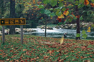
Bennett Spring State Park is a public recreation area located in Bennett Springs, Missouri, twelve miles (19 km) west of Lebanon on Highway 64 in Dallas and Laclede counties. It is centered on the spring that flows into the Niangua River and gives the park its name. The spring averages 100 million gallons of daily flow. The park offers fly fishing, camping, canoeing, hiking, and other activities.

The Illinois Central Stone Arch Railroad Bridges are a trio of limestone railroad bridges in the city of Dixon, Illinois, United States. The bridges were constructed between 1852 and 1855 as the Illinois Central Railroad laid its first rail lines across the state of Illinois. They were designed by Robert F. Laing for Laing and Douglas Construction Company, a railroad company contractor during the 1850s. Though each limestone bridge is similar in design, they each have different clearances ranging between 12 and 15 feet. The bridges remained in use by the railroad until 1985, and the three bridges were added to the U.S. National Register of Historic Places in 1987.
Schoharie Crossing State Historic Site, also known as Erie Canal National Historic Landmark, is a historic district that includes the ruins of the Erie Canal aqueduct over Schoharie Creek, and a 3.5-mile (5.6 km) long part of the Erie Canal, in the towns of Glen and Florida within Montgomery County, New York. It was the first part of the old canal to be designated a National Historic Landmark, prior to the designation of the entire New York State Barge Canal as a NHL in 2017.

Fountain Creek Bridge is a limestone arch bridge which crosses Fountain Creek near Waterloo in Monroe County, Illinois, USA. The bridge was constructed in 1849 and served as a road bridge until the 1920s, when Illinois Route 156 opened on a new bridge. During the nineteenth century, stone arch bridges were commonly built in regions with stone quarries, such as Monroe County; roughly 100 stone bridges were built in the county. The Fountain Creek Bridge is the largest remaining stone arch bridge in the county and the second-largest which was only used by road traffic in the state.
Plunketts Creek Bridge No. 3 was a rubble masonry stone arch bridge over Plunketts Creek in Plunketts Creek Township, Lycoming County in the U.S. state of Pennsylvania. It was built between 1840 and 1875, probably closer to 1840, when the road along the creek between the unincorporated villages of Barbours and Proctor was constructed. Going upstream from the mouth, the bridge was the third to cross the creek, hence its name.
The Elm Street Stone Arch Bridge is located along that street in Pine Hill, New York, United States. It is a short bridge built over Alton Creek in the early 20th century using stonemasonry techniques and an arch bridge design that had been employed in the Catskills since the 18th century, one. As one of the few extant and intact bridges in that style in the region, it was listed on the National Register of Historic Places in 1996 along with the nearby Mill Street Stone Arch Bridge. It is located in the Pine Hill Historic District.

The Mill Street Stone Arch Bridge is located on that street in Pine Hill, New York, United States. It is a small bridge over a local creek built around the turn of the 20th century. It is one of two stone arch bridges in the former village built by local stonemason Matthew G. Thompson. It has remained intact and in use since then, and was listed on the National Register of Historic Places in 1996. It is located in the Pine Hill Historic District.

The Stone Arch Bridge is a bridge in Danville, Illinois, which carries U.S. Route 136 across Stony Creek. The segmental arch bridge is 92 feet (28 m) long and built with sandstone. The bridge was built in the 1890s to facilitate Danville's expansion during an industrial boom. As various geographic and political limitations prevented the city from expanding in any directions but east and southeast, the city grew over Stony Creek, necessitating a new bridge. Mayor John Beard commissioned the bridge; during the 1890s, Beard and political rival John Cannon clashed over many issues, and Beard most likely built the bridge to demonstrate his political effectiveness. The bridge is the only segmented arch bridge remaining in east-central Illinois and is one of five stone arch bridges in the region.
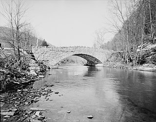
The Seguin Covered Bridge, also called the Upper Covered Bridge and the Sequin Covered Bridge, is a wooden covered bridge that crosses Lewis Creek in Charlotte, Vermont on Roscoe Road. It was built about 1850, and is a distinctive variant of a Burr arch design. It was listed on the National Register of Historic Places in 1974.

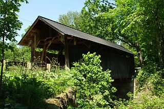
The Mull Covered Bridge is a historic wooden covered bridge in the northwestern portion of the U.S. state of Ohio. Built in the middle of the nineteenth century, it is located near Burgoon in Sandusky County. Although it is no longer used to facilitate transportation, the bridge has been preserved and is now a historic site.

The Stone Arch Bridge is a stone arch railroad bridge in Keene, New Hampshire, United States. Built in 1847 to carry the Cheshire Railroad, it is one of the best-preserved pre-1850 stone arch bridges in the nation. The bridge was listed on the National Register of Historic Places in 2012, and the New Hampshire State Register of Historic Places in 2006. It now carries a multi-purpose rail trail.

Cemetery Road Bridge is a historic bridge located in Glendale Cemetery in Washington, Illinois. The double stone arch bridge is 27 feet (8.2 m) long and carries Cemetery Road across the south branch of Farm Creek. Engineer Frederick Rickman designed the bridge for the City of Washington in 1893, and it was built the following year by stonemason Jacob Habluetzel. Habluetzel built the bridge from square cut blocks of ashlar stone. The bridge is the best-preserved bridge of its type in Tazewell County and is the only stone arch bridge in the area that is still supported solely by its arches.

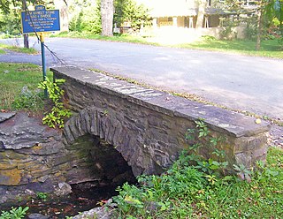
The Sacketts Brook Stone Arch Bridge, also known locally as the Hi-Lo Biddy Stone Arch Bridge, is a historic bridge just outside the village of Putney, Vermont. It is a stone arch bridge that formerly carried Mill Street across Sacketts Brook, about 0.25 miles (0.40 km) east of United States Route 5. It was built in 1906 by James Otis Follett, an area stonemason, and is one of a few surviving examples of his work. The bridge was listed on the National Register of Historic Places in 1976.

The Marble Bridge, formally known as the Fletcher D. Proctor Memorial Bridge, carries Main Street across Otter Creek in the center of Proctor, Vermont. Built in 1915 and widened in 1935-36, it is a well-preserved example of early concrete bridge construction, and is decoratively faced in local marble. The bridge was listed on the National Register of Historic Places in 1991.

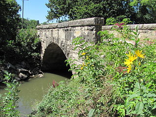
The West Sixth Street Bridge is a historic stone arch bridge in downtown Austin, Texas. Built in 1887, the bridge is one of the state's oldest masonry arch bridges. It is located at the site of the first bridge in Austin, carrying Sixth Street across Shoal Creek to link the western and central parts of the old city. The bridge was added to the National Register of Historic Places in 2014.

The West Fifth Street Bridge is a historic cantilever concrete girder bridge in downtown Austin, Texas. Built in 1931, the bridge carries Fifth Street across Shoal Creek to link central Austin with neighborhoods that were then the city's western suburbs. It is one of only a handful of curved cantilever girder bridges in Texas, built as part of the city's 1928 master plan for urban development and beautification. The bridge was added to the National Register of Historic Places in 2019.
The Fox Creek Stone Arch Bridge is a historic bridge across Fox Creek northwest of Strong City in Chase County, Kansas. The bridge was built in 1898 by B. Landry and Sons, who contracted with the Chase County government to build it for $2,000. The company built the bridge using limestone from a local quarry and arranged it in a single stone arch. The bridge is 55 feet (17 m) long and 20 feet (6.1 m) wide. It has carried county road traffic since its opening and is also part of the Community Connection Trail, which links Strong City with Tallgrass Prairie National Preserve.


