This article includes a list of references, related reading or external links, but its sources remain unclear because it lacks inline citations .(November 2016) (Learn how and when to remove this template message) |

- See Sorath for namesakes
Sorath was originally one of then pre-colonial prants into which Saurashtra peninsula in present Gujarat (western India) was divided, the very name being a Muslim amalgamation of that Ancient Greek name for the region.
A prant is a historical district in India, and a native British Raj age term for a colonial district. The same name can thus have different meanings depending on the periode.

Saurashtra, also known as Sorath or Kathiawar, is a peninsular region of Gujarat, India, located on the Arabian Sea coast. It covers about a third of Gujarat state, notably 11 districts of Gujarat, including Rajkot District.
Gujarat is a state on the western coast of India with a coastline of 1,600 km (990 mi) – most of which lies on the Kathiawar peninsula – and a population in excess of 60 million. It is the sixth largest Indian state by area and the ninth largest state by population. Gujarat is bordered by Rajasthan to the northeast, Daman and Diu to the south, Dadra and Nagar Haveli and Maharashtra to the southeast, Madhya Pradesh to the east, and the Arabian Sea and the Pakistani province of Sindh to the west. Its capital city is Gandhinagar, while its largest city is Ahmedabad. The Gujarati-speaking people of India are indigenous to the state. The economy of Gujarat is the fifth-largest state economy in India with ₹14.96 lakh crore (US$220 billion) in gross domestic product and a per capita GDP of ₹157,000 (US$2,300).
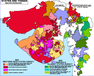
In the British raj, it was the south(west)ern-most of the four surviving prants into which the many feudal units (mostly petty princely states) of Kathiawar were regrouped, the others being Halar (west), Jhalawar (or Jalavad; north) and Gohilwad (Bhavnagar; southeast).

A princely state, also called native state, feudatory state or Indian state, was a vassal state under a local or regional ruler in a subsidiary alliance with the British Raj. Though the history of the princely states of the subcontinent dates from at least the classical period of Indian history, the predominant usage of the term princely state specifically refers to a semi-sovereign principality on the Indian subcontinent during the British Raj that was not directly governed by the British, but rather by a local ruler, subject to a form of indirect rule on some matters. In actual fact, the imprecise doctrine of paramountcy allowed the government of British India to interfere in the internal affairs of princely states individually or collectively and issue edicts that applied to all of India when it deemed it necessary.

Kathiawar is a peninsula on the Indian west coast of about 61,000 km2 (23,500 sq mi) bordering the Arabian Sea. It is bounded by the Gulf of Kutch in the northwest and by the Gulf of Khambhat in the east. In the northeast, it is connected to mainland Gujarat. It is crossed by two belts of hill country and nine leading streams. Kathiawar ports were flourishing centres of trade and commerce since at least the 16th century.

Halar(Haalaar) is a historical region of western India, located by the Gulf of Kutch coast on the northwestern area of Nawanagar, now Jamnagar, in Gujarat State, on Saurashtra peninsula, roughly corresponding to the present Jamnagar District, Devbhumi Dwarka district, Morbi District and Rajkot District.
It roughly corresponds to the modern Porbandar District and Junagadh District.
It comprised 1,193 villages, covering 5,217 square miles, with a total population of 575,288 in 1901, yielding 5,399,349 Rupees state revenue (1903-4; of which 3,610,250 from land) and paying 215,060 Rupees tribute to the British, the Gaekwar Baroda State and/or the Junagadh State.

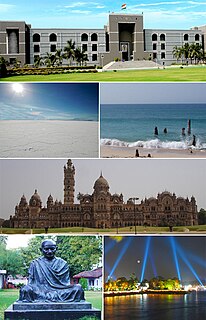
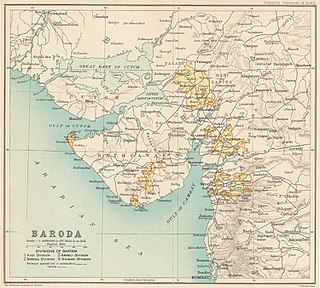
Baroda State was a state in present-day Gujarat, ruled by the Gaekwad dynasty of the Maratha Confederacy from its formation in 1721 until 1949 when it acceded to the newly formed Union of India. With the city of Baroda (Vadodara) as its capital, during the British Raj its relations with the British were managed by the Baroda Residency. At the time of Indian independence, only five rulers—the Nizam of Hyderabad, the Maharaja of Mysore, the Maharaja of Jammu and Kashmir, the Maharaja Shrimant Gaekwar of Baroda and the Maharaja Scindia of Gwalior—were entitled to a 21-gun salute. Baroda formally acceded to the Union of India, on 1 May 1949, prior to which an interim government was formed in the state.

Junagadh was a princely state in Gujarat ruled by the Muslim Babi or Babai dynasty in British India, until its integration into the Indian Union in 1948.


