
South Berwick is a town in York County, Maine, United States. The population was 7,220 at the 2010 census. South Berwick is home to Berwick Academy, a private, co-educational university-preparatory day school founded in 1791.

The Russell Center Historic District is a historic district encompassing the historic village center of Russell, Massachusetts. It is centered at the junction of Main Street and Lincoln Avenue, and is bordered by the Westfield River to the east, and the rising foothills of The Berkshires to the west. The village's 19th century development was spurred by the railroad and sustained by local papermaking businesses. It was listed on the National Register of Historic Places in 1996, and was named as one of the 1,000 places to visit in Massachusetts by the Great Places in Massachusetts Commission.

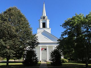
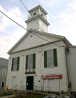
Damariscotta Baptist Church is a historic church at 4 Bristol Road in Damariscotta, Maine. Built in 1843-47 and restyled in 1891, it is a well-preserved example of Greek Revival and Colonial Revival architecture. The building also played a role in the formation of the town, and was listed on the National Register of Historic Places in 1985.

Westport Town Hall is the current town hall of Westport, Maine. It is located on Main Road in a former Congregational church built in 1794. The building, used as the town hall since 1885, was listed on the National Register of Historic Places in 2002 as Union Meeting House, (Former) [sic].
The North Stonington Village Historic District is a 105-acre (42 ha) historic district encompassing the historic center of the main village of North Stonington, Connecticut. The district includes a well-preserved small industrial village, which flourished in the years before the American Civil War, and declined afterward. The district was listed on the National Register of Historic Places in 1983.

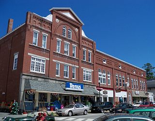
The Main Street Historic District encompasses the historic commercial center of Damariscotta, Maine. Although the community was settled in the 18th century, most of its downtown area dates to the second half of the 19th century due to an 1845 fire. Lining Main Street east of the Damariscotta River, the downtown has a well-preserved collection of commercial, residential, and civic structures from the period. The district was added to the National Register of Historic Places in 1979, and enlarged in 2001.

Yarmouth is a town in Cumberland County, Maine, located twelve miles north of the state's largest city, Portland. The town was settled, while a district of Massachusetts, in 1636 and incorporated in 1849, 29 years after its admittance to the Union. Its population was 8,349 in the 2010 census. As of 2018's estimation of 8,518, this is about 0.6% of Maine's total population. Five islands are part of the town.
The Main Street Historic District of Fryeburg, Maine, encompasses the growth of the town's principal village between about 1800 and 1935. It extends along Main Street, from Woodland Street in the north to Portland Street (SR 5 and Maine State Route 113) in the south, and includes forty primary buildings on 55 acres (22 ha). The district was listed on the National Register of Historic Places in 1991.
The Farmington Historic District encompasses much of the main central business district of Farmington, Maine. Farmington was settled in the 1770s, and experienced its most rapid growth after being named the shire town of Franklin County in 1838, with a secondary spurt of redevelopment after a major fire in the 1880s. Its central business district encompasses many of the town's historic resources, and its most significant commercial and civic architecture. The district, which includes more than 130 resource over 85 acres (34 ha), was listed on the National Register of Historic Places in 1995.
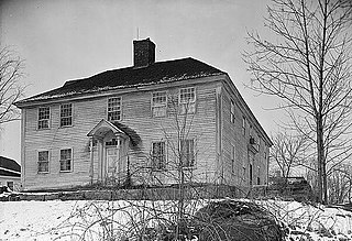
The Jewett-Eastman House is a historic house at 37 Portland Street in the center of South Berwick, Maine. Built about 1850, it is a fine local example of Greek Revival architecture. It is most notable for its association with the Jewett family, which included a prominent local businessman and a doctor, as well as the writer Sarah Orne Jewett, who was raised in this house. It served the town for a time as its public library, and is now owned by Historic New England, serving as a gallery space and as the visitors center for the adjacent Sarah Orne Jewett House.

The Portsmouth Company was a cotton mill established in 1832 in South Berwick, Maine, one of several operating in the area. It was operated for many years under the control of the Portsmouth, New Hampshire-based Hale family.

The Salmon Falls (East) Historic District encompasses a node of rural development in western Buxton, Maine. It includes thirteen historic properties, mainly Greek Revival in character, extending north along Maine State Route 117, north of its junction with Simpson Road, and two on the latter street, that were all built between about 1800 and 1850. The district was listed on the National Register of Historic Places in 1987.

The Salmon Falls (West) Historic District encompasses a cluster of well-preserved buildings built before 1840, and located on the Hollis, Maine side of the rural village of Salmon Falls. In addition to its architectural significance, the area is also noted for its association with the author Kate Douglas Wiggin, whose home, Quillcote, is in the district, as is the Salmon Falls Library, established by her efforts in 1911. The district was listed on the National Register of Historic Places in 1987.

The Gorham Historic District encompasses the traditional central civic area of Gorham, Maine. Incorporated in 1764, the town center is composed of a small cluster of civic and commercial buildings at School and Main Streets, with some residential properties radiating away. Listed on the National Register of Historic Places in 1992, the district abuts the Gorham Campus Historic District, the historic core of the campus of the University of Southern Maine.
The Putney Village Historic District encompasses most of the main village and town center of Putney, Vermont. Settled in the 1760s, the village saw its major growth in the late 18th and early 19th century, and includes a cohesive collection with Federal and Greek Revival buildings, with a more modest number of important later additions, including the Italianate town hall. The district was listed on the National Register of Historic Places in 1986.

The Wallingford Main Street Historic District encompasses the historic portions of the village of Wallingford, Vermont. An essentially linear district extending along Main Street on either side of School Street, it has a well-preserved array of 19th and early-20th century residential, commercial, and civic buildings. It was listed on the National Register of Historic Places in 1984.

The Bethel Village Historic District encompasses the historic core of the village of Bethel in the town of Bethel, Vermont, USA. The L-shaped district extends along Main and Church Streets, including many of the village's commercial and civic buildings, as well as a significant number of 19th and early 20th-century residences. The district was listed on the National Register of Historic Places in 1976, and was slightly enlarged in 1990.

The Thomaston Historic District encompasses much of the historic town center of Thomaston, Maine. With a settlement history dating to the 17th century, the town is now a showcase of 19th-century architectural styles up to the 1870s. The district extends for about 2 miles (3.2 km) along United States Route 1, and was listed on the National Register of Historic Places in 1974.

The Springfield Downtown Historic District encompasses the historic central business district of the town of Springfield, Vermont. Located in a narrow valley on the banks of the Black River, the town's architecture is primarily reflective of its importance as a manufacturing center in the late 19th and early-to-mid 20th centuries, with a cluster of commercial buildings surrounded by residential and industrial areas. It was listed on the National Register of Historic Places in 1983, and enlarged slightly in 1986.
The historical buildings and structures of Yarmouth, Maine, represent a variety of building styles and usages, largely based on its past as home to almost sixty mills over a period of roughly 250 years. These mills include that of grain, lumber, pulp and cotton. Additionally, almost three hundred vessels were launched by Yarmouth's shipyards in the century between 1790 and 1890, and the homes of master shipwrights and ship captains can still be found throughout the town.


