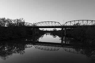
The Colorado River Bridge at Bastrop is a 1,285-foot (392 m)-long bridge with three steel truss spans and concrete piers that crosses the Colorado River as part of Loop 150 through Bastrop, Texas. The three bridge spans over the river consist of identical Parker through trusses, each 192 feet (59 m) in length, supported on concrete piers. The bridge is one of the earliest surviving uses of the Parker truss in Texas.
The Stamford Bridge, also known as Bridge No. 48-102-010, is a historic bridge in rural Mellette County, South Dakota, southeast of Stamford. Built in 1930, it is a three-span Bedstead Pony Truss bridge, carrying a local road over the White River, off County Road Ch 1. Each span measures 80 feet (24 m) in length, and the rest on two concrete piers and two concrete abutments with wing walls. The deck consists of steel I-beams, with wooden stringers topped by steel plates. The bridge is the longest Bedstead truss bridge in the state, and one of a modest number of surviving bridges built using this type of truss.
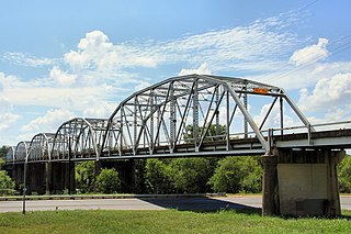
The Montopolis Bridge is a historic Parker through truss bridge in Austin, Texas. It is located in the Montopolis neighborhood where a bicycle and pedestrian walkway crosses the Colorado River in southeastern Travis County. The bridge consists of five 200-foot Parker through truss spans and four 52-foot steel I-beam approach spans resting on reinforced concrete abutments. It was added to the National Register of Historic Places on October 10, 1996.
The Parker Road–Charlotte River Bridge, also known as the 10 Mile Road–Charlotte River Bridge, is a bridge building located on Parker Road over the Charlotte River in Bruce Township, Michigan. It was listed on the National Register of Historic Places in 2000.
The Turner County Highway Department and/or its Turner County Highway Superintendent, in Turner County, South Dakota, arranged for the construction of numerous public works.

The Butts Bridge carries Butts Bridge Road over the Quinebaug River in the town of Canterbury, Connecticut. It is a well-preserved example of a Parker truss, built in 1937, late in the state's regular use of steel truss bridge designs. The bridge is also known as Bridge No. 1649 and carries an average of 2,300 vehicles per day as of 2011. It was listed on the National Register of Historic Places in 2010.
The South Dakota Dept. of Transportation Bridge No. 30-257-400 is a historic bridge in rural Hand County, South Dakota. It is located 14 miles (23 km) south of Miller and 9.7 miles (15.6 km) east, and carries a local road over Sand Creek. The bridge is a single-span steel beam stringer bridge, resting on I-beam pile abutments with concrete wings. The bridge is 26 feet (7.9 m) long. Built in 1917, it was one of the first bridges built in the county by county employees, rather than by hired bridge companies, and predates the formation of state highway department by two years.
The South Dakota Dept. of Transportation Bridge No. 20-153-210 is a historic bridge in Deuel County, South Dakota. It carries 187th Street across Cobb Creek, about 2 miles (3.2 km) east of Brandt. It is a single-span Pratt pony truss bridge, 71 feet (22 m) in length, resting on steel pilings with metal wing walls. It has corrugated metal decking resting on I-beam stringers. The bridge was built in 1908, and was originally located at a site in Herrick Township. Moved to its present location in 1960, it is the only known surviving bridge in Deuel County built by the Security Bridge Company, which held county contracts for bridge construction between 1907 and 1913.

The Lincoln Covered Bridge is a historic covered bridge, just south of U.S. Route 4 in West Woodstock, Vermont. Built in 1877, it is one of the only known examples of a wooden Pratt truss bridge in the United States. It was listed on the National Register of Historic Places in 1973.

Arch Street Bridge is Parker truss bridge over the Passaic River in Paterson, New Jersey. It was built in 1907 and rehabilitated in 1997. It was the third structure built at the location within a few years, the other having been destroyed by floods in 1902 and 1903. The bridge was once a crossing for the Public Service trolley lines.

The Bridge No. 63-137-90 is a historic bridge near Parker in rural Turner County, South Dakota. It was built sometime between 1934 and 1936, and is one of a large number of surviving stone bridges built as part of federal jobs programs in the county. It was listed on the National Register of Historic Places in 1999 as Bridge No. 63-137-090-Parker.
The Centerville Township Bridge Number S-18 is a historic stone arch bridge on 294th Lane in rural Turner County, South Dakota, west of Centerville. Built in 1938, it is one of a modest number of surviving stone arch bridges built in the county with funding from New Deal jobs programs. It was listed on the National Register of Historic Places in 2000.
South Dakota Department of Transportation Bridge No. 63-016-150 is a historic bridge in rural western Turner County, South Dakota. Built in 1935, it is a well-preserved period stone-arch bridge, built with funding from a New Deal jobs program. It was listed on the National Register of Historic Places in 1999.
The South Dakota Department of Transportation Bridge No. 63-052-030 is a historic bridge in rural Turner County, South Dakota, carrying 271st Street across the West Fork Vermillion River northwest of Marion. Built in 1913, it is the longest surviving bridge built for the county by the Federal Bridge Company of Iowa. IIt was listed on the National Register of Historic Places in 1999.

South Dakota Department of Transportation Bridge No. 63-132-040 is a historic bridge in rural Turner County, South Dakota. Built in 1939, it is a well-preserved period stone-arch bridge, built with funding from a New Deal jobs program. It was listed on the National Register of Historic Places in 1999.
The South Dakota Department of Transportation Bridge No. 63-197-130 is a historic bridge in rural Turner County, South Dakota, carrying 281st Street across the East Fork Vermillion River north of Davis. Built in 1906, it is the oldest surviving bridge built for the county by the Iowa Bridge Company. It was listed on the National Register of Historic Places in 1999.
South Dakota Department of Transportation Bridge No. 63-198-181 was a historic bridge in rural Turner County, South Dakota, carrying 460th Avenue across the East Fork Vermillion River south of Davis. Built in 1909, it was a well-preserved example of bridges built for the county by the Iowa Bridge Company. It was listed on the National Register of Historic Places in 1999.

South Dakota Department of Transportation Bridge No. 63-210-282 was a historic bridge in rural Turner County, South Dakota, carrying 461st Avenue across the East Fork Vermillion River southwest of Centerville. Built in 1909, it was a well-preserved example of bridges built for the county by the Iowa Bridge Company. It was listed on the National Register of Historic Places in 1999. The bridge's original Pratt through main span was replaced by a steel girder span in 2009–10.
Spring Valley Township Bridge No. E-31 is a historic bridge in rural Turner County, South Dakota, carrying 447th Avenue across unnamed stream west of Viborg. Built in 1938, it was a well-preserved example of a stone bridge built for the county with funding from the Works Progress Administration. It was listed on the National Register of Historic Places in 1999.

The Lyme–East Thetford Bridge is a historic bridge over the Connecticut River between Lyme, New Hampshire, and East Thetford, Vermont. From the New Hampshire side it carries East Thetford Road, which becomes Vermont Route 113 as it enters Vermont. A Parker truss bridge completed in 1937, it is 471 feet (144 m) long. The bridge was added to the National Register of Historic Places in 2020.


