
Hope is a city in Hempstead County in southwestern Arkansas, United States. Hope is the county seat of Hempstead County and the principal city of the Hope Micropolitan Statistical Area, which includes all of Hempstead and Nevada counties. As of the 2010 census the population was 10,095, and in 2019 the population was estimated at 9,599.

Hempstead County is a county located in the U.S. state of Arkansas. As of the 2010 census, the population was 22,609. The county seat is Hope. Hempstead County is Arkansas's fourth county, formed on December 15, 1818, alongside Clark and Pulaski counties. The county is named for Edward Hempstead, a delegate to the U.S. Congress from the Missouri Territory, which included present-day Arkansas at the time. It is an alcohol prohibition or dry county.

Washington is a city in Ozan Township, Hempstead County, Arkansas, United States. The population was 180 at the 2010 census, up from 148 in 2000. It is part of the Hope Micropolitan Statistical Area. The city is home to Historic Washington State Park.

Historic Washington State Park is a 101-acre (41 ha) Arkansas state park in Hemsptead County, Arkansas in the United States. The museum village contains a collection of pioneer artifacts from the town of Washington, Arkansas, which is a former pioneer settlement along the Southwest Trail. Walking interpretive tours are available throughout the 54 buildings. Washington served as a major trading point along the Southwest Trail, evolving into the Hempstead county seat and later the capital of Arkansas from 1863 to 1865 when Little Rock was threatened during the Civil War. The original plat of Washington was added to the National Register of Historic Places in 1972 as the Washington Historic District.

The President William Jefferson Clinton Birthplace Home National Historic Site is located in Hope, Arkansas. Built in 1917 by Dr. H. S. Garrett, in this house the 42nd President of the United States Bill Clinton spent the first four years of his life, having been born on August 19, 1946, at Julia Chester Hospital in Hope, Arkansas. The house was owned by Clinton's maternal grandparents, Edith Grisham and James Eldridge Cassidy, and they cared for him when his mother, Virginia, was away working as an anesthetist in New Orleans.

Camp Nichols, also known as Fort Nichols or Camp Nichols Ranch, was a short-lived historic fortification located in present-day Cimarron County, Oklahoma, about 3 miles (4.8 km) northwest of the community of Wheeless, Oklahoma. It was built by New Mexico and California volunteers under the command of Col. Kit Carson to protect travelers on the most dangerous part of the Cimarron Cut-off of the Santa Fe Trail from raids by the Kiowa and Comanche Indians. Established in May 1865 and abandoned in September 1865, it was the only manmade structure along the Cimarron Cut-off while it was an active route. It is believed to have been named for Captain Charles P. Nichols of the First California Cavalry.
The Confederate State Capitol building in Washington, Arkansas was the capital of the Confederate state government of Arkansas, during 1863–1865, after Little Rock, Arkansas fell to Union forces in the American Civil War. It is located within Historic Washington State Park, and is a National Historic Landmark.

This is a list of the National Register of Historic Places listings in Hempstead County, Arkansas.

Hope Municipal Airport is a city-owned public-use airport located four nautical miles northwest of the central business district of Hope, a city in Hempstead County, Arkansas, United States. It is included in the National Plan of Integrated Airport Systems for 2015–2019, which categorized it as a general aviation airport.
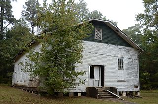
The Oak Grove Missionary Baptist Church is a historic church on Hempstead County Route 16, about 3 miles (4.8 km) south of the small town of Blevins, Arkansas. It is a single-story wood frame structure, with a Jerkinhead roof, and a steeple topped by a hip roof. It was built in 1942, using in part materials recycled from an 1870 church which was dismantled due to the establishment of the Southwestern Proving Ground in 1940. The church serves an African-American congregation that was, prior to its relocation, in a community that was originally named for, and supported by, Arkansas Senator James Kimbrough Jones. The church property includes a small wood-frame Sunday school building, constructed about the same time as the church, and a cemetery.
The First Presbyterian Church is a historic Presbyterian church at 2nd and Hempstead Streets in Nashville, Arkansas. It is now home to the Howard County Museum. The building is a single-story wood-frame structure, built in 1912. It is roughly L-shaped, and exhibits a combination of Queen Anne and Stick styling that is rare in southwestern Arkansas. The church is now owned by the local historical society, which operates it as a museum.

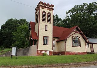
Emmet Methodist Church is a historic church at 209 S. Walnut in Emmet, Arkansas. Built between 1917 & 1918, it is one of the few Akron Plan church buildings in the state, and it is a fine local example of Colonial Revival architecture. Its main entrance is highlighted by a curved portico supported by four columns topped with simple curved capitals. The church was listed on the National Register of Historic Places in 2009. and it serves a congregation which was organized in 1855.

The Dooley's Ferry Fortifications Historic District encompasses a series of military earthworks erected in southwestern Arkansas, along the Red River in Hempstead County. They were constructed in late 1864 by Confederate troops under orders from Major-General John B. Magruder as a defense against the potential movements of Union Army forces toward Shreveport, Louisiana. They command a formerly major road intersection just east of Dooley's Ferry, one of the most important regional crossings of the Red River. After the war a cemetery for African-Americans was established adjacent to one of the gun emplacements.

The Hempstead County Courthouse is located at the northwest corner of 5th and Washington Streets in Hope, the county seat of Hempstead County, Arkansas. The five-story masonry structure was designed by the Little Rock firm of McAninch and Anderson, and built in 1939 with funding from the Public Works Administration, a depression-era federal jobs program. It is Hope's finest example of Art Deco architecture. Its entry is framed by a series of molded concrete panels, separated by inverted chevrons. The panels depict a variety of industries and professions, including construction, mining, medicine, defense, electricity, farming, and brickmaking. Chevron paneling is repeated in the cornice. The interior of the building is virtually unaltered, except for two courtrooms on the upper floors, which required complete renovation following a lightning-induced fire in 1979. The 1939 building has had a large jail added, but this was done in a sympathetic manner to the original's design.

The Mounds Cemetery is a historic cemetery in rural Hempstead County, Arkansas. It is located off County Road 13, northwest of the small community of Columbus. It is significant as the site of two Caddoan mounds, and as the burying ground for some of Hempstead County's earliest white settlers. It is further significant as a stopping site along the Trail of Tears, the forced westward relocation of Native Americans in the 19th century.
The Southwestern Proving Ground Building No. 5 is an ammunition storage bunker at 259 Hempstead County Road 279 in Oakhaven, Arkansas, northwest of the city of Hope.
The Southwestern Proving Ground Building No. 129 is a military powder magazine at 195 Hempstead County Road 279 in Oakhaven, Arkansas, northwest of the city of Hope. It is located on property that was once part of the Southwestern Proving Ground, a major military facility during World War II whose largest portion was transformed into Hope Municipal Airport. Building No. 129 is a single-story brick and tile structure, with two bays. There are red steel doors located on the northeast and southwest facades. The roof is gabled, and covered in fire-resistant asbestos sheeting, with vents at the ridge, and an elaborate lightning-protection system. It was built in 1941 to house smokeless gunpowder, and is one of only two brick buildings from the proving ground to survive. It is now used by a private owner for storage.

The North Elm Street Historic District is a predominantly residential historic district in Hope, Arkansas. The district is rectangular in shape, roughly bounded on the north by Avenue G, on the west by Hervey Street, on the east by Hazel Street, and on the south by the railroad tracks. Most of the residential structures in this area were built between 1890 and 1945, and represent the city's greatest concentration of homes built during its boom years. The only major institutional building in the district is Hope City Hall, a Classical Revival structure.

The Southwestern Proving Ground Officers Quarters Historic District is a residential historic district encompassing most of the town of Oakhaven, Arkansas. Located at the western end of Oakhaven Road, the district includes 20 houses built in 1941 to provide housing for military officers serving at the Southwestern Proving Ground, of which this area was then a part. After World War II came to an end, the properties were sold off to local veterans, who incorporated Oakhaven soon afterward. The houses are all two story wood frame structures resting on brick foundations. Most of the houses have hip roofs, although those reserved for the highest-ranking officers had gable roofs. They are typically three bays wide with a center entry, and feature modest Colonial Revival styling.

Bent's New Fort was a historic fort and trading post along the banks of the Arkansas River in what is now Bent County, Colorado, about nine miles west of Lamar, on the Mountain Route branch of the Santa Fe Trail. William Bent operated a trading post with limited success at the site and in 1860 leased the fort to the United States government, which operated it as a military outpost until 1867. In 1862, it was named Fort Lyon. The fort was abandoned after a flood of the Arkansas River in 1867.

