
Mitchell County is a county located in the U.S. state of North Carolina. As of the 2010 census, the population was 15,579. Its county seat is Bakersville, population 454 (2010), elevation 2470 ft.

Spruce Pine is a town in Mitchell County, North Carolina, United States. The population was 2,175 at the 2010 census.

Mount Mitchell, known in Cherokee as Attakulla, is the highest peak of the Appalachian Mountains and the highest peak in mainland eastern North America. It is located near Burnsville in Yancey County, North Carolina; in the Black Mountain subrange of the Appalachians, about 19 miles (31 km) northeast of Asheville. It is protected by Mount Mitchell State Park and surrounded by the Pisgah National Forest. Mount Mitchell's elevation is 6,684 feet (2,037 m) above sea level.

North Mountain is a peak in the Catskill Mountains of New York, on the border between the towns of Catskill and Hunter, in Greene County. It is part of the Catskill Escarpment. Cairo Round Top is located northeast and Artists Rock is located southeast of North Mountain.

The Chilcotin Ranges are a subdivision of the Pacific Ranges of the Coast Mountains. They lie on the inland lea of the Pacific Ranges, abutting the Interior Plateau of British Columbia. Their northwestern end is near the head of the Klinaklini River and their southeast end is the Fraser River just north of Lillooet; their northern flank is the edge of the Plateau while their southern is the north bank of the Bridge River. In some reckonings they do not go all the way to the Fraser but end at the Yalakom River, which is the North Fork of the Bridge.

The Spruce Lake Protected Area, was a 71,347-hectare Protected Area in the British Columbia provincial parks system 200 km north of Vancouver. The area had been the subject of an ongoing preservationist controversy since the 1930s. Formerly known variously as the Southern Chilcotin Mountains Provincial Park, Southern Chilcotins, and also as South Chilcotin Provincial Park. In 2007, its status as a provincial park was downgraded to protected area.

Spruce Mountain is a mountain in Elko County, Nevada, United States. It was named from the spruce timber near the summit. Spruce Mountain ranks twenty-fifth among the most topographically prominent peaks in the state. The summit is at 10,267 feet (3,129 m). Spruce Mountain is on a northeast–southwest trending ridge with a parallel Spruce Ridge to the northwest. To the east, a low section of hills connects the mountain to the south end of the Pequop Mountains. US Route 93 passes the southwest end of the mountain. The peak is on public land administered by the Bureau of Land Management and thus has no access restrictions.

Blow-me-down Brook is a 12.8-mile (20.6 km) long stream located in western New Hampshire in the United States. It is a tributary of the Connecticut River, which flows to Long Island Sound.
Picea obovata, the Siberian spruce, is a spruce native to Siberia, from the Ural Mountains east to Magadan Oblast, and from the Arctic tree line south to the Altay Mountains in northwestern Mongolia.
Pennsylvania Route 45 is an 86-mile-long (138 km) state highway located in central Pennsylvania, United States. PA 45 is called the Purple Heart Highway. The western terminus of the route is at PA 453 in Morris Township near the community of Water Street. The eastern terminus is at PA 642 west of the small town of Mooresburg.

The North Fork Umatilla Wilderness is a wilderness area located inside the Umatilla National Forest, in the Blue Mountains of northeastern Oregon. It is the smallest wilderness in northeast Oregon, encompassing only 20,144 acres (8,152 ha) in Umatilla and Union counties.
Mount Guyot is a mountain located in Grafton County, New Hampshire. The mountain is named after Professor Arnold H. Guyot (1807–1884) of Princeton University, and is part of the Twin Range of the White Mountains. Mount Guyot is flanked to the northwest by South Twin Mountain, to the northeast by Mount Zealand, and to the south by Mount Bond. Guyot is on the northern boundary of the Pemigewasset Wilderness. The immediate area around the summit consists of high-altitude spruce-fir forest or krummholz.
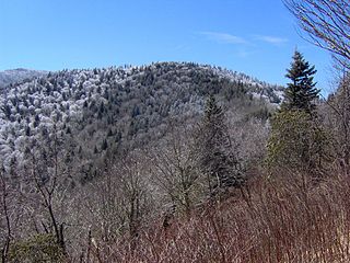
Old Black is a mountain in the Great Smoky Mountains, located in the Southeastern United States. While often overshadowed by Mount Guyot, its higher neighbor to the south, Old Black is the 5th-highest mountain in Tennessee and the 7th-highest in the Great Smoky Mountains National Park. The Appalachian Trail crosses its western slope, connecting the Cosby-area trail system with the heart of the Eastern Smokies.

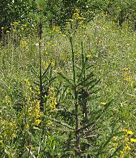
Woody's Knob, at an elevation of 4,170 feet, is a summit or "knob" in the Blue Ridge Mountains and one of the highest points in the unincorporated village of Little Switzerland and in Mitchell County, North Carolina.
Misery Mountain, 2,671 feet (814 m), with at least ten well-defined summits, is a prominent 6 mi (9.7 km) long ridgeline in the Taconic Mountains of western Massachusetts and adjacent New York. The west side of the mountain is located in New York; the east side and high point lie within Massachusetts. The summit ridge is part meadow and part wooded with red spruce, balsam fir, and northern hardwood tree species. It is notable for its views of the Hudson River Valley to the west. The 35 mi (56 km) Taconic Crest Trail traverses the crest of the ridgeline, but does not cross the summit.
Mount Vic 3005 m (9859 ft), prominence: 712 m, is a mountain in the Chilcotin Ranges of the Central Interior of British Columbia, Canada, located east of the southernmost of the Taseko Lakes and southeast of Taseko Mountain. Adjoining its lower slopes to the northeast is the Dil-Dil Plateau, a lava plateau rising above the main Chilcotin Plateau, which extends north and northeast in general from this area, which is to the west of the headwaters of Big Creek. Mount Vic is one of the highest summits of the southern Chilcotin Ranges, which are a subrange of the Pacific Ranges subdivision of the Coast Mountains.

Spruce Mountain, in eastern West Virginia, USA, is the highest ridge of the Allegheny Mountains. The "whale-backed" ridge extends for only about 16 miles (26 km), from northeast to southwest, but several of its peaks exceed 4,500 feet (1,400 m) in elevation. The summit, Spruce Knob, is celebrated as the highest point in the state as well as the range, which covers parts of four states.
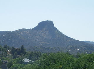
The Sierra Prieta is a 14 miles (23 km) long mountain range in central-northwest Arizona. The range is the mountainous region west of Prescott, with prominent Thumb Butte, 6,514 feet (1,985 m), a volcanic plug, on the city's west perimeter.

Spruce Top is a mountain located in Greene County, New York southwest of Tannersville, New York. Located to the southwest is Plateau Mountain and to the southeast is Sugarloaf Mountain. Spruce Top drains into Cook Brook and Roaring Kill, which both flow in a general northeast direction before converging with the Schoharie Creek.
Hemlock Mountain is a mountain located in the Catskill Mountains of New York northeast of Frost Valley. Spruce Mountain is located northwest, Wildcat Mountain is located southwest and Panther Mountain is located northeast of Hemlock Mountain.

