
Girouxville is a village in northern Alberta, Canada. It is located 58 kilometres (36 mi) south of the Town of Peace River.
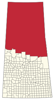
Division No. 18, Saskatchewan, Canada, is one of the eighteen Statistics Canada census divisions within the province, occupying the northern half of the province. The census division is coextensive with the Northern Saskatchewan Administration District (NSAD).
Halbrite is a village in the Canadian province of Saskatchewan within the Rural Municipality of Cymri No. 36 and Census Division No. 2. The village is located approximately 20 kilometres southeast of the City of Weyburn on Highway 39 at the intersections of Highway 606 and 705.
Buffalo Narrows is a northern village in Saskatchewan, Canada. It is a community of 1,110 people. Located at the "Narrows" between Peter Pond Lake and Churchill Lake, tourism and resource extraction are its main economic activities.
Bangor is a village in the Canadian province of Saskatchewan within the Rural Municipality of Fertile Belt No. 183 and Census Division No. 5.
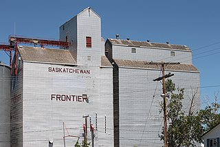
Frontier is a village in the Canadian province of Saskatchewan within the Rural Municipality of Frontier No. 19 and Census Division No. 4. Frontier is on Highway 18 and is served by the Frontier Airport located (3.7 km) south of the village.

Bracken is a village in the Canadian province of Saskatchewan within the Rural Municipality of Lone Tree No. 18 and Census Division No. 4. The village is named after John Bracken, Premier of Manitoba and leader of the Progressive Conservative Party of Canada, who was a professor at the University of Saskatchewan. The small village is located approximately 160 km south of the City of Swift Current on Highway 18, directly north of Grasslands National Park, and approximately 20 km north of the Montana-Saskatchewan border.
Dorintosh is a village in the Canadian province of Saskatchewan within the Rural Municipality of Meadow Lake No. 588 and Census Division No. 17.
Goodsoil is a village in the Canadian province of Saskatchewan within the Rural Municipality of Beaver River No. 622 and Census Division No. 17. The Goodsoil Historical Museum Site is a municipal heritage property on the Canadian Register of Historic Places. It is the western gateway to Meadow Lake Provincial Park.
Tramping Lake is a village in the Canadian province of Saskatchewan within the Rural Municipality of Tramping Lake No. 380 and Census Division No. 13. The village gets its name from nearby Tramping Lake.
Jans Bay is a northern hamlet in the Canadian province of Saskatchewan.
Lancer is a village in the Canadian province of Saskatchewan within the Rural Municipality of Miry Creek No. 229 and Census Division No. 8.

Meota is a village in the Canadian province of Saskatchewan within the Rural Municipality of Meota No. 468 and Census Division No. 17. The village name is derived from the Cree phrase Meotate or Mo-Was-In-Ota, meaning "good place to camp" or "it is good here."
Paradise Hill is a village in the Canadian province of Saskatchewan within the Rural Municipality of Frenchman Butte No. 501 and Census Division No. 17.
Turnor Lake is a community on the southern shore of Turnor Lake. From Highway 155 it is accessible by Highway 909. The community includes the Northern Hamlet of Turnor Lake and Turnor Lake 193B of the Birch Narrows First Nation.
Primate is a special service area within the Rural Municipality of Eye Hill No. 382, Saskatchewan, Canada that held village status prior to 2016.
Tantallon is a village in the Canadian province of Saskatchewan within the Rural Municipality of Spy Hill No. 152 and Census Division No. 5. It is in the Qu'Appelle Valley along the Qu'Appelle River about 32 km east of Round Lake (Saskatchewan). The community celebrated its centennial in 2004.
Cole Bay is a northern hamlet in Saskatchewan's northern boreal forest. It is located on the southern shore of Canoe Lake. The population in the Canada Census of 2011 was 230, an increase of 47.4% over 156 in 2006.
Michel Village is a northern hamlet in Saskatchewan. It is located on the western shore of Peter Pond Lake at the end of Highway 925 north of Dillon. There were 66 residents in Michel Village in 2011. The mayor is Cliff Coombs.
The North Battleford Crown Colony is an unincorporated community within the Rural Municipality of North Battleford No. 437 in Saskatchewan, Canada that is designated a census subdivision by Statistics Canada. It is adjacent to the City of North Battleford and is home to the Saskatchewan Hospital North Battleford.

