The Eastern Suburbs & Illawarra Line is a commuter railway line in the eastern and southern suburbs of Sydney and is a part of the Sydney Trains network. The line was constructed in the 1880s to Wollongong to take advantage of agricultural and mining potentials in the Illawarra area. In March 1926 it became the first railway in New South Wales to run electric train services.

Stanwell Park is a picturesque coastal village and northern suburb of Wollongong, New South Wales, Australia. It is the northernmost point of the Illawarra coastal strip and lies south of Sydney's Royal National Park. It is situated in a small valley between Bald Hill to the north, Stanwell Tops to the west and Mount Mitchell to the south. It has two lagoons from the village's two creeks, Stanwell and Hargrave Creeks and a beach running between headlands. Like other towns in the region the village is known colloquially known as TFOE, this is an acronym for the postcode (2508).

The South Coast railway line is a commuter and goods railway line in New South Wales, Australia. Beginning at the Illawarra Junction, the line primarily services the Illawarra and South Coast regions of New South Wales, and connects Sydney and Bomaderry through Wollongong and Kiama.

Otford is a former village, now satellite housing in the Otford Valley just 60 km to the south of the Sydney metropolitan area and north of the Illawarra and Wollongong in New South Wales, Australia. Otford is within the local government area of Wollongong City Council.

Stanwell Park railway station is located on the South Coast railway line in New South Wales, Australia. It serves the seaside village of Stanwell Park opening on 23 December 1901, relocating to its current location on 10 October 1920.

The South Coast Line is an intercity rail service operated by NSW TrainLink that services the Illawarra region of New South Wales, Australia. The service runs from Central, and runs the entire length of the eponymous South Coast railway line to Bomaderry. The service also runs along the Eastern Suburbs railway line at peak hours and the Port Kembla railway line to Port Kembla. It is operated with NSW TrainLink H sets and Sydney Trains T sets, with Endeavour railcars operating the service on the non-electrified line between Kiama and Bomaderry.
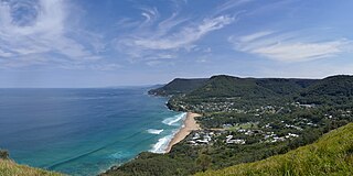
Bald Hill is a hill on the Illawarra Range, in the state of New South Wales, Australia. With an elevation of approximately 300 metres (980 ft) AMSL, Bald Hill is one of the best known and most popular lookouts in the Illawarra region providing panoramic vistas across the Illawarra escarpment and over the Illawarra plain and the Tasman Sea of the South Pacific Ocean.

Helensburgh railway station is a heritage-listed railway station located on the South Coast railway line in New South Wales, Australia. It serves the town of Helensburgh. It was added to the New South Wales State Heritage Register on 2 April 1999.

Thirroul railway station is a heritage-listed railway station on the South Coast railway line in New South Wales, Australia. It serves the northern Wollongong suburb of Thirroul. It was added to the New South Wales State Heritage Register on 2 April 1999.

The Illawarra escarpment, or officially the Illawarra Range, is the fold-created cliffs and plateau-eroded outcrop mountain range west of the Illawarra coastal plain south of Sydney, in the state of New South Wales, Australia. The range encloses the Illawarra region which stretches from Stanwell Park in the north to Kiama, Gerringong and the Shoalhaven River in the south.
Helensburgh is a small town in New South Wales, Australia. Helensburgh is located 45 kilometres south of the Sydney central business district and 34 kilometres (21 mi) north of Wollongong. Helensburgh is in the local government area of Wollongong City Council and marks the northern end of the Illawarra region. It is approximately halfway between Sydney and Wollongong, at the southern end of the Royal National Park.
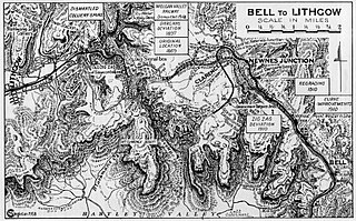
The Ten Tunnels Deviation is a heritage-listed 9.2-kilometre (5.7 mi) section of the Main Western Line between Newnes Junction and Zig Zag stations in Lithgow, New South Wales, Australia. It was designed and built by the New South Wales Government Railways and built from 1 June 1908 and 16 October 1910. It is also known as Great Zig Zag Railway deviation tunnels and Bell to Zig Zag Ten Tunnel Railway Deviation. It was added to the New South Wales State Heritage Register on 2 April 1999.

The Goulburn Viaduct is a heritage-listed railway bridge that carries the Main Southern railway line across the Mulwaree River at Goulburn, in the Goulburn Mulwaree Council local government area of New South Wales, Australia. It was built in 1915. It is also known as Mulwaree River Railway Viaduct. The property is owned by RailCorp, an agency of the Government of New South Wales. It was added to the New South Wales State Heritage Register on 2 April 1999.
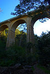
The Otford railway tunnel is a heritage-listed former railway tunnel on the Illawarra railway line at Otford, City of Wollongong, New South Wales, Australia. It was designed by the New South Wales Government Railways, and built by W. Rowe and W. Smith (tunnel) and Mr. McDonald. The property is owned by RailCorp, an agency of the Government of New South Wales. It was added to the New South Wales State Heritage Register on 2 April 1999.
Lilyvale railway tunnels are heritage-listed railway tunnels on the Illawarra railway line at Lilyvale, City of Wollongong, New South Wales, Australia. It was designed and built by the then-New South Wales Government Railways. The property is owned by RailCorp, an agency of the Government of New South Wales. It was added to the New South Wales State Heritage Register on 2 April 1999.
The Argyle Street railway bridge is a heritage-listed railway bridge on the Main Southern railway line (146.037 km) at Moss Vale, Wingecarribee Shire, New South Wales, Australia. It was designed and built by the New South Wales Government Railways in 1914 with steel supplied by Dorman Long of Middlesbrough, England. The property is owned by RailCorp, an agency of the Government of New South Wales. It was added to the New South Wales State Heritage Register on 2 April 1999.

The Bargo Railway Viaduct is a heritage-listed railway viaduct over the Bargo River located on the Main South railway approximately 96 kilometres (60 mi) from Central, in the south-western Sydney settlement of Bargo in the Wollondilly Shire local government area of New South Wales, Australia. The viaduct was designed by New South Wales Government Railways and built in 1919. It is also known as Bargo River Railway Viaduct. The property is owned by RailCorp, an agency of the Government of New South Wales. It was added to the New South Wales State Heritage Register on 2 April 1999.

The Bowenfels rail viaducts are a series of heritage-listed railway viaducts and railway bridges over Farmers Creek on the Main Western line in Bowenfels, City of Lithgow, New South Wales, Australia. It was designed in two stages, by John Whitton as the Engineer-in-Chief for Railways, in 1870; and by engineering staff of New South Wales Government Railways in 1921; and was built from 1870 to 1921. It is also known as Farmers Creek viaducts. The property is owned by RailCorp, an agency of the Government of New South Wales. It was added to the New South Wales State Heritage Register on 2 April 1999. The viaduct are located approximately 159 kilometres (99 mi) west of Central railway station.

The Coxs River railway bridges are two heritage-listed railway bridges that carry the Main Western line over the Coxs River at Wallerawang, City of Lithgow, New South Wales, Australia. The bridges were designed by engineering staff of the New South Wales Government Railways and built in 1870 by day labour. The property is owned by RailCorp, an agency of the Government of New South Wales. It was added to the New South Wales State Heritage Register on 2 April 1999.

The Glebe and Wentworth Park railway viaducts are a series of two adjacent heritage-listed railway bridges and arch viaducts that carry the Inner West Light Rail across Wentworth Park, Jubilee Park, and Johnstons Creek in the inner western Sydney suburb of Glebe in the City of Sydney local government area of New South Wales, Australia. They were designed by the New South Wales Government Railways and built from 1892 to 1922 by day labour. They are also known as Wentworth Park Viaduct, Jubilee Park Viaduct and Glebe Viaducts. The viaducts were added to the New South Wales State Heritage Register on 2 April 1999.