Steuben, Wisconsin | |
---|---|
Coordinates: 43°10′52″N90°51′33″W / 43.18111°N 90.85917°W | |
Country | United States |
State | Wisconsin |
County | Crawford |
Government | |
• Type | Village |
• Village President | Shawn Pickett |
Area | |
• Total | 6.19 sq mi (16.04 km2) |
• Land | 6.19 sq mi (16.04 km2) |
• Water | 0.00 sq mi (0.00 km2) |
Elevation | 676 ft (206 m) |
Population | |
• Total | 131 |
• Estimate (2019) [4] | 122 |
• Density | 19.71/sq mi (7.61/km2) |
Time zone | UTC-6 (Central (CST)) |
• Summer (DST) | UTC-5 (CDT) |
Area code | 608 |
FIPS code | 55-77175 [5] |
GNIS feature ID | 1574872 [2] |
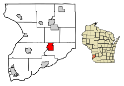
Steuben is a village in Crawford County, Wisconsin, United States. The population was 131 at the 2010 census.
Steuben is located at 43°10′52″N90°51′33″W / 43.181190°N 90.859068°W (43.181190, -90.859068). [6]
According to the United States Census Bureau, the village has a total area of 6.19 square miles (16.03 km2), all of it land. [7]
Census | Pop. | Note | %± |
---|---|---|---|
1910 | 237 | — | |
1920 | 305 | 28.7% | |
1930 | 262 | −14.1% | |
1940 | 321 | 22.5% | |
1950 | 264 | −17.8% | |
1960 | 193 | −26.9% | |
1970 | 179 | −7.3% | |
1980 | 175 | −2.2% | |
1990 | 161 | −8.0% | |
2000 | 177 | 9.9% | |
2010 | 131 | −26.0% | |
2019 (est.) | 122 | [4] | −6.9% |
U.S. Decennial Census [8] |
As of the census [3] of 2010, there were 131 people, 51 households, and 34 families living in the village. The population density was 21.2 inhabitants per square mile (8.2/km2). There were 64 housing units at an average density of 10.3 per square mile (4.0/km2). The racial makeup of the village was 99.2% White and 0.8% Native American.
There were 51 households, of which 41.2% had children under the age of 18 living with them, 52.9% were married couples living together, 9.8% had a female householder with no husband present, 3.9% had a male householder with no wife present, and 33.3% were non-families. 29.4% of all households were made up of individuals, and 19.6% had someone living alone who was 65 years of age or older. The average household size was 2.57 and the average family size was 3.12.
The median age in the village was 34.8 years. 30.5% of residents were under the age of 18; 5.4% were between the ages of 18 and 24; 32.1% were from 25 to 44; 19.8% were from 45 to 64; and 12.2% were 65 years of age or older. The gender makeup of the village was 51.1% male and 48.9% female.
As of the census [5] of 2000, there were 177 people, 61 households, and 45 families living in the village. The population density was 28.6 people per square mile (11.0/km2). There were 72 housing units at an average density of 11.6 per square mile (4.5/km2). The racial makeup of the village was 99.44% White and 0.56% Native American. Hispanic or Latino of any race were 0.56% of the population.
There were 61 households, out of which 47.5% had children under the age of 18 living with them, 63.9% were married couples living together, 4.9% had a female householder with no husband present, and 24.6% were non-families. 23.0% of all households were made up of individuals, and 9.8% had someone living alone who was 65 years of age or older. The average household size was 2.90 and the average family size was 3.35.
In the village, the population was spread out, with 32.2% under the age of 18, 9.0% from 18 to 24, 29.9% from 25 to 44, 16.9% from 45 to 64, and 11.9% who were 65 years of age or older. The median age was 31 years. For every 100 females, there were 98.9 males. For every 100 females age 18 and over, there were 106.9 males.
The median income for a household in the village was $41,250, and the median income for a family was $42,500. Males had a median income of $27,500 versus $16,563 for females. The per capita income for the village was $11,657. About 7.4% of families and 7.2% of the population were below the poverty line, including 7.4% of those under the age of eighteen and 16.0% of those 65 or over.
Scotsdale is a village in Jefferson County, Missouri, United States. The population was 222 at the 2010 census.
Mackenzie is an unincorporated community in St. Louis County, Missouri, United States. The population was 134 at the 2010 census.
Velda Village Hills is a city in northeastern St. Louis County, Missouri, United States. The population was 1,055 at the 2010 census.
Hanley Hills is a village in St. Louis County, Missouri, United States. The population was 2,101 at the 2010 census.
Valleyview is a village in Franklin County, Ohio, United States. The population was 669 at the 2020 census.
Blue River is a village in Grant County, Wisconsin, United States. The population was 434 at the 2010 census.
Tennyson is a village in Grant County, Wisconsin, United States, originally called Dutch Hollow. The population was 355 at the 2010 census.
Avoca is a village in Iowa County, Wisconsin, United States. The population was 637 at the 2010 census. It is part of the Madison Metropolitan Statistical Area. It is named after Avoca in Ireland.
Rewey is a village in Iowa County, Wisconsin, United States. The population was 292 at the 2010 census. It is part of the Madison Metropolitan Statistical Area.
Boaz is a village in Richland County, Wisconsin, United States. According to the 2010 census, the population of the village was 156.
Yuba is a village in Richland County, Wisconsin, United States. The population was 74 at the 2010 census. Yuba is 11 miles southwest of Hillsboro and 17 miles north of Richland Center. County Hwy C runs through the village.
Readstown is a village in Vernon County, Wisconsin, United States. The population was 376 at the 2020 census.
Dorchester is a village in Clark and Marathon counties in the U.S. state of Wisconsin, along the 45th parallel. It is part of the Wausau, Wisconsin Metropolitan Statistical Area. The population was 876 at the 2010 census. Of this, 871 were in Clark County, and only 5 were in Marathon County.
Viola is a village in Richland (mostly) and Vernon counties in the U.S. state of Wisconsin. The population was 699 at the 2010 census. Of this, 477 were in Richland County, and 222 were in Vernon County.
Bloomington is a village in Grant County, Wisconsin, United States. The population was 735 as of the 2010 census. The village is located within the Town of Bloomington.
Mount Hope is a village in Grant County, Wisconsin, United States. The population was 225 at the 2010 census. The village is located within the Town of Mount Hope.
Patch Grove is a village in Grant County, Wisconsin, United States. The population was 198 at the 2010 census. The village is located within the Town of Patch Grove.
Woodman is a village in Grant County in the U.S. state of Wisconsin. The population was 132 at the 2010 census. The village is located within the Town of Woodman.
Melrose is a village in Jackson County, Wisconsin, United States. The population was 503 at the 2010 census. The village is located within the Town of Melrose.
Oakdale is a village in Monroe County, Wisconsin, United States. The population was 302 at the 2020 census. The village is located within the Town of Oakdale.