
Tucson is a city in and the county seat of Pima County, Arizona, United States, and is home to the University of Arizona. It is the second-largest city in Arizona behind Phoenix, with a population of 542,629 in the 2020 United States census, while the population of the entire Tucson metropolitan statistical area (MSA) is 1,043,433. The Tucson MSA forms part of the larger Tucson-Nogales combined statistical area (CSA). Both Tucson and Phoenix anchor the Arizona Sun Corridor. The city is 108 miles (174 km) southeast of Phoenix and 60 mi (97 km) north of the U.S.–Mexico border. Tucson is the 34th-largest city and the 53rd-largest metropolitan area in the United States (2014).

Old Pueblo Trolley is a non-profit, educational corporation based in Tucson, in the U.S. state of Arizona, that is dedicated to the preservation of Arizona's mass transit history. The name also commonly refers to the heritage streetcar line which OPT began operating in 1993, on which service is currently indefinitely suspended. OPT consists of three divisions that each fill a specific role in preserving the state's mass transit history. The divisions are the Street Railway Division, Motor Bus Division and the Museum Division.
Josias Thomas Joesler was a Swiss-American Tucson, Arizona architect.
Henry O. Jaastad (1872–1965) was an influential Tucson, Arizona architect. His firm created over 500 buildings and Jaastad was Mayor of Tucson for 14 years. A number of his works are listed on the U.S. National Register of Historic Places for their architecture.
The El Paso and Southwestern Railroad began in 1888 as the Arizona and South Eastern Railroad, a short line serving copper mines in southern Arizona. Over the next few decades, it grew into a 1200-mile system that stretched from Tucumcari, New Mexico, southward to El Paso, Texas, and westward to Tucson, Arizona, with several branch lines, including one to Nacozari, Mexico. The railroad was bought by the Southern Pacific Railroad in 1924 and fully merged into its parent company in 1955. The EP&SW was a major link in the transcontinental route of the Golden State Limited.
Temple Emanu-El is a Reform synagogue in Tucson, Arizona. It was the first synagogue in the Arizona Territory and is the oldest congregation in the state; Emanuel's original building, known as the Stone Avenue Temple, is the oldest synagogue building in Arizona.

Pima County Courthouse is the former main county courthouse building in downtown Tucson, Arizona. It is listed on the National Register of Historic Places. It was designed by Roy Place in 1928 in Mission Revival and Spanish Colonial Revival style architecture.

This is a list of the National Register of Historic Places listings in Cochise County, Arizona. It is intended to be a complete list of the properties and districts on the National Register of Historic Places in Cochise County, Arizona, United States. The locations of National Register properties and districts for which the latitude and longitude coordinates are included below, may be seen in a map.
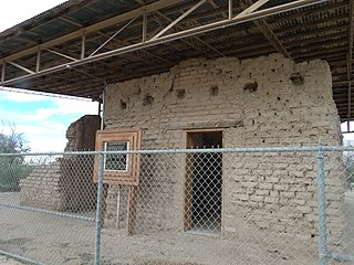
Fort Lowell was a United States Army post active from 1873 to 1891 on the outskirts of Tucson, Arizona. Fort Lowell was the successor to Camp Lowell, an earlier Army installation. The Army chose a location just south of the confluence of the Tanque Verde and Pantano creeks, at the point where they form the Rillito River, due to the year-round supply of water during that period. The Hohokam natives had chosen the site centuries earlier, presumably for the same reason. To this day, shards of Hohokam pottery can still be found in the area. The Army claimed a military reservation that encompassed approximately eighty square miles and extended east toward the Rincon Mountains.
The Jewish History Museum, formerly known as the Jewish Heritage Center of the Southwest, is a museum housed in a historic synagogue building in Tucson, Arizona. The museum's building, which housed the first synagogue in the Arizona Territory, is the oldest synagogue building in the state.

U.S. Route 80 (US 80) also known as the Ocean-to-Ocean Highway, the Broadway of America and the Jefferson Davis Memorial Highway was a major transcontinental highway that existed in the U.S. state of Arizona from November 11, 1926, to October 6, 1989. At its peak, US 80 traveled from the California border in Yuma to the New Mexico state line near Lordsburg. US 80 was an important highway in the development of Arizona's car culture. Like its northern counterpart, US 66, the popularity of travel along US 80 helped lead to the establishment of many unique road side businesses and attractions, including many iconic motor hotels and restaurants. US 80 was a particularly long highway, reaching a length of almost 500 miles (800 km) within the state of Arizona alone for most of the route's existence.
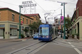
Sun Link, also known as the Tucson Streetcar, is a single-line streetcar system in Tucson, Arizona, United States, that began service in July 2014. The system's 3.9-mile (6.3 km) route connects the Arizona Health Sciences Center, the University of Arizona campus, the Main Gate and 4th Avenue shopping and entertainment districts, downtown Tucson, the Tucson Convention Center, and the Mercado District under development west of Interstate 10. The streetcar project's overall cost of $196 million was met through a combination of local funding sources and federal grants. The streetcar shares a common payment system with the Sun Tran regional bus service. In 2021, the line had a ridership of 897,100, or about 4,400 per weekday as of the third quarter of 2022.
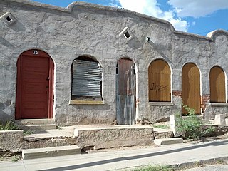
Barrio Libre is a neighborhood in Tucson, Arizona notable for its existence as a relatively unchanged 19th-century Hispanic neighborhood of close-packed row houses. Houses in the barrio are typically adobe with very plain detailing, reflecting the area's history as a district of townhouses for Mexican ranching families. The district includes more than 200 contributing structures, with relatively few non-conforming buildings. The district is bounded by 14th and 18th streets to the north and south, and by Stone and Osborne to the east and west. Meyer Avenue runs through the center of the barrio.

The Arizona Inn is a hotel in Tucson, Arizona. It was built in 1930–31 by Isabella Greenway, who became Arizona's first female representative to the U.S. Congress in 1932. The Spanish Colonial Revival main building was designed by Tucson architect Merritt Starkweather. The entire 14-acre (5.7 ha) complex comprises 25 structures, of which 21 contribute to the historic district. The buildings are pink stuccoed masonry structures with blue details, arranged in landscaped gardens with more pink stucco walls. The gardens were designed by landscape architect James Oliphant. Small structures surround the gardens, which are mainly landscaped with native Arizona plants.

The Miracle Mile Historic District, located on North Stone Avenue, Drachman Street, Oracle Road and Miracle Mile in Tucson, Arizona, United States, was listed as a historic district on the National Register of Historic Places in 2017.


