Stryn Municipality

Last updated
Stryn Municipality
Stryn kommune
Stryn.jpg
View of Stryn
Flag of Stryn.gif
Stryn komm.svg
Norway Counties Vestland Position.svg
Vestland within Norway
NO 4651 Stryn.svg
Stryn within Vestland
Coordinates: 61°50′19″N06°51′46″E / 61.83861°N 6.86278°E / 61.83861; 6.86278
Country Norway
County Vestland
District Nordfjord
Established1843
  Preceded by Innvik Municipality
Administrative centre Stryn
Government
  Mayor (2019)Per Kjøllesdal (Sp)
Area
  Total
1,382.02 km2 (533.60 sq mi)
  Land1,325.7 km2 (511.9 sq mi)
  Water56.32 km2 (21.75 sq mi)  4.1%
  Rank#67 in Norway
Highest elevation
[1]
2,081.44 m (6,828.9 ft)
Population
 (2025)
  Total
7,311
  Rank#140 in Norway
  Density5.3/km2 (14/sq mi)
  Change (10 years)
Increase2.svg +1.9%
Demonym Stryning [2]
Official language
[3]
   Norwegian form Nynorsk
Time zone UTC+01:00 (CET)
  Summer (DST) UTC+02:00 (CEST)
ISO 3166 code NO-4651 [4]
Website Official website

Stryn is a municipality in the county of Vestland, Norway. It is located in the traditional district of Nordfjord. The administrative center of the municipality is the village of Stryn. The municipality is located along the innermost part of the Nordfjorden. Some of the main villages in Stryn Municipality include Loen, Innvik, Utvik, Randabygda, Olden, and Flo.

Contents

View towards Stryn summer ski center Resort Overview.JPG
View towards Stryn summer ski center
Innvik Church Innvik kirke.jpg
Innvik Church
Oppstrynsvatnet Lake Oppstrynsvatnet.JPG
Oppstrynsvatnet Lake

The 1,382-square-kilometre (534 sq mi) municipality is the 67th largest by area out of the 357 municipalities in Norway. Stryn Municipality is the 140th most populous municipality in Norway with a population of 7,311. The municipality's population density is 5.3 inhabitants per square kilometre (14/sq mi) and its population has increased by 1.9% over the previous 10-year period. [5] [6]

Farming, forestry, fruit growing, animal breeding for furs, small manufacturing industries, tourism, and the service trades provide the main occupations. The river Stryneelva enters the village of Stryn from the east after passing through the Stryn Valley, from the large lake Oppstrynsvatn. The Jostedalsbreen National Park Center is on the shore of the lake.

Stryn Municipality has year-round glacier skiing at Stryn Sommerski. It is also the home of the footballer-brothers Tore André Flo, Jarle Flo and Jostein Flo, who grew up in the village of Stryn, as well as their footballing-cousin Håvard Flo who is from the village of Flo.

General information

The parish of Indvigen (later spelled "Innvik") was established as Innvik Municipality on 1 January 1838 (see formannskapsdistrikt law). The original municipality was identical to the Innvik prestegjeld with the parishes (sokn) of Oppstryn, Nedstryn, Loen, Olden, Innvik, and Utvik. In 1843, the large Innvik Municipality was divided into two. The parishes of Loen, Oppstryn, and Nedstryn (population: 2,401) were separated and established as the new Stryn Municipality. The parishes of Olden, Innvik, and Utvik (population: 2,675) continued on as a much smaller Innvik Municipality. [7]

On 10 January 1922, the Raksgrenda area (population: 120) was transferred from Innvik Municipality to Stryn Municipality. [7]

During the 1960s, there were many municipal mergers across Norway due to the work of the Schei Committee. On 1 January 1965, a merger took place combining the following areas into a new, much larger Stryn Municipality with a population of 7,211. [7]

On 1 January 1977, the parts of the old Hornindal Municipality that were merged into Stryn Municipality in 1965 were transferred back to the newly re-constituted Hornindal Municipality. The population of Stryn Municipality was reduced by 1,202 in this border adjustment. [7]

On 1 January 2019, the Maurset area in the southern part of the neighboring Hornindal Municipality (population: 19) was transferred from Hornindal Municipality to Stryn Municipality. [8]

Historically, this municipality was part of the old Sogn og Fjordane county. On 1 January 2020, the municipality became a part of the newly-formed Vestland county (after Hordaland and Sogn og Fjordane counties were merged). [9]

Name

The municipality (originally the parish) is likely named after the local river Stryneelva (Old Norse : Strjónar). The name is derived from the word strjónn which means "(strong) stream". [10]

Coat of arms

The coat of arms was granted on 11 December 1987. The official blazon is "Vert, a linden branch Or in bend sinister with four leaves" (Norwegian : På grønn grunn ein venstre skråstilt gull lindekvist med fire blad). This means the arms have a green field (background) and the charge is a linden (tilia) branch with four leaves. The charge has a tincture of Or which means it is commonly colored yellow, but if it is made out of metal, then gold is used. The linden was chosen to represent the vast deciduous forests in the region, the branch represents the main fjord through the municipality, and the four leaves were chosen to represent the four main village areas along the fjord. The arms were designed by Heidi Heggdal. The municipal flag has the same design as the coat of arms. [11] [12] [13]

Olden Church Olden kyrkje, Stryn, Northeast view 20150603 1.jpg
Olden Church
Nordsida Church Nordsida kirke.jpg
Nordsida Church

Churches

The Church of Norway has eight parishes (sokn) within Stryn Municipality. It is part of the Nordfjord prosti (deanery) in the Diocese of Bjørgvin. [14]

Churches in Stryn Municipality
Parish (sokn)Church nameLocation of the churchYear built
Oppstryn Oppstryn Church Oppstryn 1863
Nedstryn Nedstryn Church Nedstryn 1859
Loen Loen Church Loen 1838
Innvik Innvik Church Innvik 1822
Utvik Utvik Church Utvik 1840
Olden Olden Church Olden 1934
Old Olden Church 1772
Ljosheim Chapel Mykløy in Oldedalen 1924
Randabygda Randabygd Church Randabygda 1916
Nordsida Nordsida Church Roset 1973

Government

Stryn Municipality is responsible for primary education (through 10th grade), outpatient health services, senior citizen services, welfare and other social services, zoning, economic development, and municipal roads and utilities. The municipality is governed by a municipal council of directly elected representatives. The mayor is indirectly elected by a vote of the municipal council. [15] The municipality is under the jurisdiction of the Sogn og Fjordane District Court and the Gulating Court of Appeal.

Municipal council

The municipal council (Kommunestyre) of Stryn Municipality is made up of 25 representatives that are elected to four year terms. The tables below show the current and historical composition of the council by political party.

Stryn kommunestyre 20232027 [16]   
Party name (in Nynorsk)Number of
representatives
  Labour Party (Arbeidarpartiet)3
  Progress Party (Framstegspartiet)2
  Conservative Party (Høgre)6
  Christian Democratic Party (Kristeleg Folkeparti)2
  Red Party (Raudt)1
  Centre Party (Senterpartiet)8
  Liberal Party (Venstre)3
Total number of members:25
Stryn kommunestyre 20192023 [17]   
Party name (in Nynorsk)Number of
representatives
  Labour Party (Arbeidarpartiet)4
  Progress Party (Framstegspartiet)1
  Conservative Party (Høgre)8
  Christian Democratic Party (Kristeleg Folkeparti)1
  Centre Party (Senterpartiet)9
  Liberal Party (Venstre)2
Total number of members:25
Stryn kommunestyre 20152019 [18]   
Party name (in Nynorsk)Number of
representatives
  Labour Party (Arbeidarpartiet)3
  Progress Party (Framstegspartiet)1
  Conservative Party (Høgre)10
  Christian Democratic Party (Kristeleg Folkeparti)2
  Centre Party (Senterpartiet)7
  Liberal Party (Venstre)2
Total number of members:25
Stryn kommunestyre 20112015 [19]   
Party name (in Nynorsk)Number of
representatives
  Labour Party (Arbeidarpartiet)4
  Progress Party (Framstegspartiet)2
  Conservative Party (Høgre)8
  Christian Democratic Party (Kristeleg Folkeparti)2
  Centre Party (Senterpartiet)7
  Liberal Party (Venstre)2
Total number of members:25
Stryn kommunestyre 20072011 [18]   
Party name (in Nynorsk)Number of
representatives
  Labour Party (Arbeidarpartiet)7
  Progress Party (Framstegspartiet)3
  Conservative Party (Høgre)3
  Christian Democratic Party (Kristeleg Folkeparti)2
  Centre Party (Senterpartiet)8
  Socialist Left Party (Sosialistisk Venstreparti)1
  Liberal Party (Venstre)1
Total number of members:25
Stryn kommunestyre 20032007 [18]   
Party name (in Nynorsk)Number of
representatives
  Labour Party (Arbeidarpartiet)7
  Progress Party (Framstegspartiet)2
  Conservative Party (Høgre)3
  Christian Democratic Party (Kristeleg Folkeparti)3
  Centre Party (Senterpartiet)7
  Socialist Left Party (Sosialistisk Venstreparti)2
  Liberal Party (Venstre)1
Total number of members:25
Stryn kommunestyre 19992003 [18]   
Party name (in Nynorsk)Number of
representatives
  Labour Party (Arbeidarpartiet)5
  Progress Party (Framstegspartiet)4
  Conservative Party (Høgre)5
  Christian Democratic Party (Kristeleg Folkeparti)4
  Centre Party (Senterpartiet)11
  Liberal Party (Venstre)2
Total number of members:31
Stryn kommunestyre 19951999 [20]   
Party name (in Nynorsk)Number of
representatives
  Labour Party (Arbeidarpartiet)5
  Progress Party (Framstegspartiet)3
  Conservative Party (Høgre)6
  Christian Democratic Party (Kristeleg Folkeparti)3
  Centre Party (Senterpartiet)12
  Liberal Party (Venstre)2
Total number of members:31
Stryn kommunestyre 19911995 [21]   
Party name (in Nynorsk)Number of
representatives
  Labour Party (Arbeidarpartiet)6
  Progress Party (Framstegspartiet)1
  Conservative Party (Høgre)7
  Christian Democratic Party (Kristeleg Folkeparti)3
  Red Electoral Alliance (Raud Valallianse)1
  Centre Party (Senterpartiet)12
  Liberal Party (Venstre)1
Total number of members:31
Stryn kommunestyre 19871991 [22]   
Party name (in Nynorsk)Number of
representatives
  Labour Party (Arbeidarpartiet)7
  Conservative Party (Høgre)10
  Christian Democratic Party (Kristeleg Folkeparti)5
  Red Electoral Alliance (Raud Valallianse)1
  Centre Party (Senterpartiet)12
  Liberal Party (Venstre)2
Total number of members:37
Stryn kommunestyre 19831987 [23]   
Party name (in Nynorsk)Number of
representatives
  Labour Party (Arbeidarpartiet)9
  Conservative Party (Høgre)9
  Christian Democratic Party (Kristeleg Folkeparti)6
  Centre Party (Senterpartiet)11
  Liberal Party (Venstre)2
Total number of members:37
Stryn kommunestyre 19791983 [24]   
Party name (in Nynorsk)Number of
representatives
  Labour Party (Arbeidarpartiet)7
  Conservative Party (Høgre)8
  Christian Democratic Party (Kristeleg Folkeparti)6
  Centre Party (Senterpartiet)11
  Liberal Party (Venstre)3
  Local list for Olden (Bygdeliste for Olden)2
Total number of members:37
Stryn kommunestyre 19751979 [25]   
Party name (in Nynorsk)Number of
representatives
  Labour Party (Arbeidarpartiet)4
  Conservative Party (Høgre)5
  Christian Democratic Party (Kristeleg Folkeparti)5
  Centre Party (Senterpartiet)7
  Liberal Party (Venstre)2
  Common list for Hornindal (Samlingslista for Hornindal)4
  Non-party election list from Hornindal
(Upolitisk Valliste frå Hornindal)
1
  Local list for the old Stryn Muunicipality with Nordsida
(Bygdeliste for tidlegare Stryn kommune med Nordsida)
4
  Local list for Innvik, Utvik, and Tistam
(Bygdeliste for Innvik, Utvik og Tistam)
2
  Local list for Olden (Bygdeliste for Olden)3
Total number of members:37
Stryn kommunestyre 19711975 [26]   
Party name (in Nynorsk)Number of
representatives
  Labour Party (Arbeidarpartiet)7
  Conservative Party (Høgre)4
  Christian Democratic Party (Kristeleg Folkeparti)5
  Centre Party (Senterpartiet)13
  Liberal Party (Venstre)3
  Local List(s) (Lokale lister)5
Total number of members:37
Stryn kommunestyre 19671971 [27]   
Party name (in Nynorsk)Number of
representatives
  Labour Party (Arbeidarpartiet)6
  Conservative Party (Høgre)6
  Christian Democratic Party (Kristeleg Folkeparti)5
  Centre Party (Senterpartiet)11
  Liberal Party (Venstre)4
  Local List(s) (Lokale lister)5
Total number of members:37
Stryn kommunestyre 19631967 [28]   
Party name (in Nynorsk)Number of
representatives
  Labour Party (Arbeidarpartiet)4
  Conservative Party (Høgre)3
  Christian Democratic Party (Kristeleg Folkeparti)2
  Centre Party (Senterpartiet)8
  Liberal Party (Venstre)3
  Local List(s) (Lokale lister)1
Total number of members:21
Note: On 1 January 1965, Innvik Municipality and some other smaller areas became part of Stryn Municipality.
Stryn heradsstyre 19591963 [29]   
Party name (in Nynorsk)Number of
representatives
  Labour Party (Arbeidarpartiet)4
  Conservative Party (Høgre)3
  Centre Party (Senterpartiet)9
  Liberal Party (Venstre)4
  Local List(s) (Lokale lister)1
Total number of members:21
Stryn heradsstyre 19551959 [30]   
Party name (in Nynorsk)Number of
representatives
  Labour Party (Arbeidarpartiet)4
  Conservative Party (Høgre)2
  Farmers' Party (Bondepartiet)10
  Liberal Party (Venstre)5
Total number of members:21
Stryn heradsstyre 19511955 [31]   
Party name (in Nynorsk)Number of
representatives
  Labour Party (Arbeidarpartiet)5
  Conservative Party (Høgre)2
  Farmers' Party (Bondepartiet)11
  Liberal Party (Venstre)6
Total number of members:24
Stryn heradsstyre 19471951 [32]   
Party name (in Nynorsk)Number of
representatives
  Labour Party (Arbeidarpartiet)4
  Farmers' Party (Bondepartiet)9
  Liberal Party (Venstre)4
  Local List(s) (Lokale lister)7
Total number of members:24
Stryn heradsstyre 19451947 [33]   
Party name (in Nynorsk)Number of
representatives
  Labour Party (Arbeidarpartiet)5
  Farmers' Party (Bondepartiet)10
  Liberal Party (Venstre)6
  Local List(s) (Lokale lister)3
Total number of members:24
Stryn heradsstyre 19371941* [34]   
Party name (in Nynorsk)Number of
representatives
  Labour Party (Arbeidarpartiet)3
  Farmers' Party (Bondepartiet)8
  Liberal Party (Venstre)5
  Local List(s) (Lokale lister)8
Total number of members:24
Note: Due to the German occupation of Norway during World War II, no elections were held for new municipal councils until after the war ended in 1945.

Mayors

The mayor (Nynorsk : ordførar) of Stryn Municipality is the political leader of the municipality and the chairperson of the municipal council. Here is a list of people who have held this position:

  • 1843–1844: Arent Uchermann
  • 1845–1845: Ole Vik
  • 1846–1847: Harald Kolbeinsson Gutdal
  • 1848–1851: Peter L. Brandt
  • 1853–1855: Peter L. Brandt
  • 1857–1859: G. A. Heiberg
  • 1860–1863: Jon Nilsson Seime
  • 1864–1890: Arne Olsson Tonning
  • 1890–1910: Sigmund Kolbeinsen Aarnes
  • 1913–1928: Rasmus Larsson Skåre
  • 1928–1928: Per Nedreberg
  • 1929–1937: Per Lunde
  • 1938–1940: Per Nedreberg
  • 1941–1945: Nils Bergem
  • 1945–1945: Per Nedreberg
  • 1946–1952: Jon Øvre-Flo
  • 1952–1959: Rasmus Langeset
  • 1960–1964: Audun Næss
  • 1965–1971: Knut Mork
  • 1972–1975: Mathias Hilde
  • 1976–1976: Paul Svarstad (H)
  • 1977–1983: Leiv Blakset (Sp)
  • 1984–1987: Oddvin Drageset (Sp)
  • 1988–1991: Inger Hoff (H)
  • 1992–1999: Oddvin Drageset (Sp)
  • 1999–2011: Nils Petter Støyva (Ap)
  • 2011–2019: Sven Flo (H)
  • 2019–present: Per Kjøllesdal (Sp)

Geography

Lovatnet Loenvatnet 2.JPG
Lovatnet
Oppstrynsvatnet Oppstrynsvatnet (2093156113).jpg
Oppstrynsvatnet
Briksdal Glacier Briksdalsbreen (03 272).jpg
Briksdal Glacier
Road to the Jostedal Glacier The road to Jostedals Glacier.jpg
Road to the Jostedal Glacier
Loen Loen.JPG
Loen

Location

Stryn Municipality is located on the northern border of Vestland county. To the north, Stryn Municipality is bordered by Volda Municipality and Stranda Municipality (in Møre og Romsdal county), to the east is Skjåk Municipality (in Innlandet county), to the southeast is Luster Municipality, to the southwest is Sunnfjord Municipality, and to the west is Gloppen Municipality and Stad Municipality.

Nature

Stryn Municipality is known for its scenery, glaciers and the mountains running into the mirroring fjords and lakes. The glacier Briksdalsbreen lies in the Oldedalen valley. The Stryn area also has a number of other valley glaciers including Tindefjellsbreen, Tystigsbreen, and Myklebustbreen. Most of the valley glaciers in Stryn Municipality are originating from the great Jostedal Glacier between the Nordfjord and Sogn areas.

Ramnefjellsfossen, the third highest free-falling waterfall in the world, is located in the municipality. Stryn Municipality also has the largest linden forest in Northern Europe. The largest lakes are Oppstrynsvatnet, Lovatnet, and Oldevatnet. The highest point in the municipality is the 2,081.44-metre (6,828.9 ft) tall mountain Lodalskåpa, located on the border with Luster Municipality. [1] The mountains Skåla and Høgstre Breakulen are also located in Stryn.

Jostedal Glacier National Park

The Jostedalsbreen National Park has an area of approximately 1,310 square kilometres (510 sq mi). Flora and fauna area is situated between the fjord and glacier. The museum Jostedalsbreen National Park Center is located in Oppstryn.

Briksdal glacier

Visitors from all over the world come to see the Briksdalsbreen glacier outlet, which is situated amid waterfalls and high peaks. Briksdal glacier is a part of the Jostedal Glacier ice field, which is the largest glacier on the European mainland. The highest point of the glacier lies at 1,950 metres (6,400 ft) above sea level and in some places it measures 400 metres (1,300 ft) in depth. It is located at the end of the Oldedalen valley.
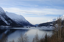
Lodalen–Kjenndalen

On two occasions, large rockslides from Ramnefjellet hit the lake below. The resulting flood wave wiped out the settlements of Nesdal and Bødal, killing 135 people.

Wildlife

There are many bird species in this area including the golden eagle (Aquila chrysaetos), rough-legged buzzard (Buteo lagopus), and the white-backed woodpecker (Dendrocopus leucotos). Some of the larger mammals that live in this region are red deer (Cervus elaphus), wolverines (Gulo gulo), and lynxes (Lynx lynx).

Attractions

National Tourist Route

The Gamle Strynefjellsvegen is a National Tourist Route (Fylkesvei 258). It goes from Grotli (Skjåk Municipality in Innlandet county) to Videseter, where a waterfall is, and on to the village of Stryn (Vestland county).

Stryn Center

The village of Stryn, a busy and developing small village at the tip of the most northernly of the three short branches at the inner end of Nordfjorden, is the local government and shopping centre for a large community and the junction of roads which connect inner Nordfjord with the rest of Norway.

Oldedalen Valley

The southernmost of the three short branches at the inner end of Nordfjorden terminates at the village of Olden from which a lovely valley, Oldedalen, goes due south for about 20 kilometres (12 mi) between slopes rising sharply to more than 1,700 metres (5,600 ft) to the edge of the Jostedal Glacier.

Olden has two churches. The Old Olden Church in the village, was built in 1759 on the site of a Stave church dating from around 1300. Its pews, doors, and jambs are made from timbers of the Stave church. The "new" Olden Church, a short distance along the valley, was built in 1934 so that the old church could be preserved.

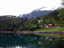
Loen and Lodalen Valley

The Loen Skylift is located in Loen, and Hotel Alexandra is a popular tourist retreat. Loen Valley (Lodalen) is a popular attraction, and Kjenndal Glacier is located at the end of the valley (branch of the Jostedal Glacier). Much of the upper Loen valley was devastated from two rockfall slides (one in 1905 and one in 1936) that created huge waves that swept with them most of the houses and vegetation. A total of 135 people were killed in these two incidents.

Innvik and Utvik

On the southern shore of the Nordfjorden, between Hildaneset and Utvikfjellet, lie the villages of Innvik and Utvik, in the area known as Vikane. The main road (Rv 60) skirts the fjord past Innvik and ascends from Utvik to Utvikfjellet mountain. At Hildaneset, beside the main road, there is a sculpture of Mr. Singer. Mr Singer financed the building of the road.

Notable people

Johs. Andenaes Johs. Andenaes OB.O76-3179.jpg
Johs. Andenæs

Sport

References

  1. 1 2 "Høgaste fjelltopp i kvar kommune" (in Norwegian). Kartverket. 16 January 2024.
  2. "Navn på steder og personer: Innbyggjarnamn" (in Norwegian). Språkrådet.
  3. "Forskrift om målvedtak i kommunar og fylkeskommunar" (in Norwegian). Lovdata.no.
  4. Bolstad, Erik; Thorsnæs, Geir, eds. (9 January 2024). "Kommunenummer". Store norske leksikon (in Norwegian). Foreningen Store norske leksikon.
  5. Statistisk sentralbyrå. "Table: 06913: Population 1 January and population changes during the calendar year (M)" (in Norwegian).
  6. Statistisk sentralbyrå. "09280: Area of land and fresh water (km²) (M)" (in Norwegian).
  7. 1 2 3 4 Jukvam, Dag (1999). "Historisk oversikt over endringer i kommune- og fylkesinndelingen" (PDF) (in Norwegian). Statistisk sentralbyrå. ISBN   9788253746845.
  8. "Justering av grensa mellom kommunane Stryn og Hornindal" (in Norwegian). Kommunal- og moderniseringsdepartementet. 1 December 2018. Retrieved 29 April 2019.
  9. Thorsnæs, Geir, ed. (1 August 2025). "Vestland". Store norske leksikon (in Norwegian). Foreningen Store norske leksikon. Retrieved 10 October 2025.
  10. Rygh, Oluf (1919). Norske gaardnavne: Nordre Bergenhus amt (in Norwegian) (12 ed.). Kristiania, Norge: W. C. Fabritius & sønners bogtrikkeri. p. 511.
  11. "Civic heraldry of Norway - Norske Kommunevåpen". Heraldry of the World. Retrieved 12 May 2023.
  12. "Stryn, Sogn og Fjordane (Norway)". Flags of the World. Retrieved 12 May 2023.
  13. "Godkjenning av våpen og flagg". Lovdata.no (in Norwegian). Norges kommunal- og arbeidsdepartementet. 11 December 1987. Retrieved 12 May 2023.
  14. "Kyrkjer i Stryn" (in Norwegian). NRK.no. 27 May 2002. Retrieved 29 June 2008.
  15. Hansen, Tore; Vabo, Signy Irene, eds. (25 November 2024). "kommunestyre". Store norske leksikon (in Norwegian). Foreningen Store norske leksikon. Retrieved 31 December 2024.
  16. "Kommunestyrevalg 2023 - Vestland". Valgdirektoratet . Retrieved 21 January 2024.
  17. "Kommunestyrevalg 2019 – Vestland". Valgdirektoratet . Retrieved 29 October 2019.
  18. 1 2 3 4 "Table: 04813: Members of the local councils, by party/electoral list at the Municipal Council election (M)" (in Norwegian). Statistics Norway.
  19. "Kommunestyrevalg 2011 – Sogn og Fjordane". Valgdirektoratet . Retrieved 29 October 2019.
  20. "Kommunestyrevalget 1995" (PDF) (in Norwegian). Oslo-Kongsvinger: Statistisk sentralbyrå. 1996. Retrieved 18 February 2020.
  21. "Kommunestyrevalget 1991" (PDF) (in Norwegian). Oslo-Kongsvinger: Statistisk sentralbyrå. 1993. Retrieved 18 February 2020.
  22. "Kommunestyrevalget 1987" (PDF) (in Norwegian). Oslo-Kongsvinger: Statistisk sentralbyrå. 1988. Retrieved 18 February 2020.
  23. "Kommunestyrevalget 1983" (PDF) (in Norwegian). Oslo-Kongsvinger: Statistisk sentralbyrå. 1984. Retrieved 18 February 2020.
  24. "Kommunestyrevalget 1979" (PDF) (in Norwegian). Oslo: Statistisk sentralbyrå. 1979. Retrieved 18 February 2020.
  25. "Kommunevalgene 1975" (PDF) (in Norwegian). Oslo: Statistisk sentralbyrå. 1977. Retrieved 1 May 2020.
  26. "Kommunevalgene 1972" (PDF) (in Norwegian). Oslo: Statistisk sentralbyrå. 1973. Retrieved 1 May 2020.
  27. "Kommunevalgene 1967" (PDF) (in Norwegian). Oslo: Statistisk sentralbyrå. 1967. Retrieved 1 May 2020.
  28. "Kommunevalgene 1963" (PDF) (in Norwegian). Oslo: Statistisk sentralbyrå. 1964. Retrieved 1 May 2020.
  29. "Kommunevalgene og Ordførervalgene 1959" (PDF) (in Norwegian). Oslo: Statistisk sentralbyrå. 1960. Retrieved 1 May 2020.
  30. "Kommunevalgene og Ordførervalgene 1955" (PDF) (in Norwegian). Oslo: Statistisk sentralbyrå. 1957. Retrieved 1 May 2020.
  31. "Kommunevalgene og Ordførervalgene 1951" (PDF) (in Norwegian). Oslo: Statistisk sentralbyrå. 1952. Retrieved 1 May 2020.
  32. "Kommunevalgene og Ordførervalgene 1947" (PDF) (in Norwegian). Oslo: Statistisk sentralbyrå. 1948. Retrieved 1 May 2020.
  33. "Kommunevalgene og Ordførervalgene 1945" (PDF) (in Norwegian). Oslo: Statistisk sentralbyrå. 1947. Retrieved 1 May 2020.
  34. "Kommunevalgene og Ordførervalgene 1937" (PDF) (in Norwegian). Oslo: Statistisk sentralbyrå. 1938. Retrieved 1 May 2020.
  35. Thoralf Klouman at IMDb. Retrieved 18 September 2020.