 Real Time Java applet display of SuperDARN network for the Americas
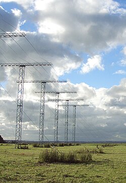 The Unwin Radar is a scientific radar array at Awarua Plain near Invercargill, New Zealand
Super Dual Auroral Radar Network | |
| Established | 1993 |
|---|---|
| Purpose | Research of the Ionosphere |
| Affiliations | Contents
|

The Super Dual Auroral Radar Network (SuperDARN) is an international scientific radar network [1] [2] consisting of 41 [3] high frequency (HF) radars located in both the Northern and Southern Hemispheres. SuperDARN radars are primarily used to map high-latitude plasma convection in the F region of the ionosphere, but the radars are also used to study a wider range of geospace phenomena including field aligned currents, magnetic reconnection, geomagnetic storms and substorms, magnetospheric MHD waves, mesospheric winds via meteor ionization trails, and interhemispheric plasma convection asymmetries. [2]
The SuperDARN collaboration is composed of radars operated by JHU/APL, Virginia Tech, Dartmouth College, the Geophysical Institute at the University of Alaska Fairbanks, the Institute of Space and Atmospheric Studies at the University of Saskatchewan, the University of Leicester, Lancaster University, La Trobe University, the Solar-Terrestrial Environment Laboratory at Nagoya University, the British Antarctic Survey and the Institute for Space Astrophysics and Planetology (INAF-IAPS Italy).

