
Wahkeena Falls is a 242-foot (74 m) waterfall in the Columbia River Gorge in the state of Oregon.

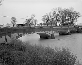
Rainbow Dam is a hydroelectric dam on the Missouri River, 29 feet (8.8 m) high and 1,055 feet (322 m) long, located six miles northeast of Great Falls in the U.S. state of Montana.

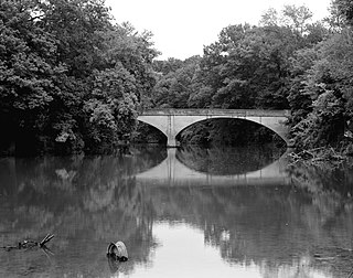
Ryan Dam is a hydroelectric dam on the Missouri River, 10 miles (16 km) downstream from the city of Great Falls in the U.S. state of Montana. The dam is 1,336 feet (407 m) long and 61 feet (19 m) high; its reservoir is 7 miles (11 km) long and has a storage capacity of 5,000 acre-feet (6,200,000 m3). It is a run-of-river dam. The dam is built on the largest of the five Great Falls of the Missouri, the "Big Falls", also sometimes called "Great Falls". Since 1915, the six-unit powerhouse on the left side of the dam has occupied a significant portion of the 87-foot (27 m) high waterfall.

Wilson River Bridge, also known as Wilson River Bridge at Tillamook or Wilson River Bridge No. 01499, is a bridge near Tillamook, Oregon, United States. The 1931 bridge was designed by Conde McCullough in the Classical Revival and Art Deco styles. It covers a span of 180 feet (55 m) and brings coastal U.S. Route 101 (US 101) over the Wilson River.

The Lewis and Clark Bridge is a historic bridge in Wolf Point, Montana, which once carried Montana Highway 13 across the Missouri River between McCone and Roosevelt counties. It is also known as Wolf Point Bridge, Missouri River Bridge, or Site No. 24RV438. The bridge is a five-span Pennsylvania through truss; its longest span is the longest through truss span in the state at 400-foot (120 m). Completed in 1930 by the Missouri Valley Bridge and Iron Company, the bridge was the first bridge across the Missouri River at Wolf Point and the only bridge along the river for a 350-mile (560 km) stretch. The bridge's opening ceremony, which took place on July 9, drew over 10,000 visitors and included five bands and a fireworks display. After its completion, the bridge became a popular tourist attraction for motorists in northeastern Montana and a point of civic pride for Wolf Point's residents.

The Zion – Mount Carmel Highway is a 25-mile (40 km) long road in Washington and Kane counties in southern Utah, United States, that is listed on the National Register of Historic Places and is a National Historic Civil Engineering Landmark.

The Hayden Arch Bridge is a concrete arch bridge on old US 14/US 16 near Cody, Wyoming. It is the only example of its kind in Wyoming. Built in 1924–25, the single-span bridge spans 115 feet (35 m) with two smaller approach arches between rock canyon walls. The bridge carries the Cody-Yellowstone Highway across the Shoshone River with a shallow open-spandrel central arch and nominally arched approach spans. The bridge is named after C. E. Hayden, an engineer with the Wyoming State Highway Department, who designed the bridge and supervised its construction. It was built by H. S. Crocker of Denver, Colorado.

Snowden Bridge is a high-clearance, vertical-lift railroad bridge, built in 1913, that spans the Missouri River between Roosevelt and Richland Counties in Montana, USA, between Bainville and Fairview, Montana, and near Fort Union Trading Post National Historic Site and the ghost town of Mondak near Montana's eastern border with North Dakota. Snowden Bridge is a near twin of the Fairview Bridge, which crosses the Yellowstone River in North Dakota, both bridges having been built by Montana Eastern Railway within 10 miles (16 km) of each other over different rivers in different states.

The Narada Falls Bridge is a reinforced concrete arch bridge in Mount Rainier National Park, spanning the Paradise River above Narada Falls. The bridge was built in 1927–1928 by contractor J. D. Tobin of Portland, Oregon, who built the Christine Falls Bridge at the same time. The arch spans 36 feet (11 m). The bridge is 20 feet (6.1 m) wide, with an additional 3.5 feet (1.1 m) on either side for sidewalks. It was faced with rubble stone masonry and is an example of National Park Service Rustic design. The bridge is not open for public traffic, and leads to the Narada park utility area.
The Illinois River Bridge, also known as the Midway Bridge, is a historic concrete arch bridge near Siloam Springs, Arkansas. It is located in Ozark National Forest, about 6 miles (9.7 km) east of Siloam Springs, at the end of Chambers Springs Road south of United States Route 412. The bridge has two elliptical arch spans, each spanning 68 feet (21 m), with a total structure length of 139 feet (42 m). Built in 1922 by the Luten Bridge Company of Knoxville, Tennessee, it is one of a modest number of bridges of this once-popular and common type remaining in the state.

The Dearborn River High Bridge is a Pratt half-deck truss bridge built in 1897, and has been placed on the National Register of Historic Places as it is one of the few bridges of its type left standing in the United States. On a half-deck bridge, the deck is attached in the center rather than, as is more common, top or bottom of the superstructure. It crosses the Dearborn River on Lake Bean Road about 15 miles (24 km) southwest of Augusta, Montana. The unusual design of the Dearborn River High Bridge suits it to carry light loads across high/deep crossings. It has four spans and a wooden plank deck. It is the last standing pin-connected Pratt half-deck truss bridge left in the United States. Construction cost was $9,997. Construction began in 1896 and completed in 1897.
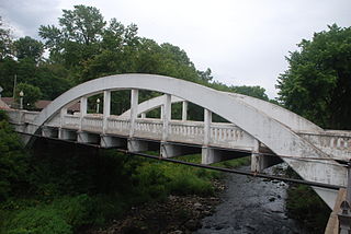
The Marsh Rainbow Arch Bridge is a historic bridge over Duncan Creek located in Chippewa Falls, Wisconsin. It was added to the National Register of Historic Places in 1982.

George H. Shanley was an architect of Great Falls, Montana.

The Cascade Bridge is a historic structure located in Burlington, Iowa, United States. In April 1896 the Burlington City Council approved a proposal to have city engineer S.D. Eaton advertise for plans and estimates for a bridge on Main Street that would span Cascade Ravine. The Cascade Lumber Company had petitioned for the bridge. The city contracted with the Cedar Rapids, Iowa firm of Boynton & Warriner to design the structure and the Milwaukee Bridge and Iron Works to erect the span. The city was responsible for building the concrete substructure. The bridge was completed in the fall of 1896, and is composed of four spans. The span length is 160 feet (49 m), and its total length is 464 feet (141 m). The span is a Baltimore deck truss bridge with Pratt deck trusses at both ends. The structure is supported by stone and concrete abutments with concrete pedestals and a single concrete-filled steel cylinder pier. Over the years the original deck has been replaced, and concrete has been applied to the stone abutments. Otherwise the structure has been unaltered. The bridge was listed on the National Register of Historic Places in 1998.

The Middle Fork of the Little Red River Bridge, also known as the Shirley Railroad Bridge, is a historic bridge in Shirley, Arkansas. It is a single-span iron Baltimore through truss, with a main span 153 feet (47 m) long, and steel beam approach spans giving it a total length of 339 feet (103 m). The main span rests on large concrete piers set in the river. The bridge was built in 1908 for the Missouri and North Arkansas Railroad, and carried the railroad until 1949. In 1978 the tracks were covered by a concrete deck, and the bridge was converted to single-lane vehicular road use, carrying County Road 125.

The Fourche LaFave River Bridge carries Arkansas Highway 7 across the Fourche LaFave River in western Perry County, Arkansas, downstream of the Nimrod Dam. It is a three-span open spandrel concrete arch bridge, with its longest span measuring 184 feet (56 m), and its total length 518 feet (158 m). The arches are mounted on concrete abutments and piers. The bridge deck is asphalt, and is lined by ornate concrete balustrades. It was built in 1941 by the Luten Bridge Company, and is a well-preserved example of style from that period.

Fort Benton Bridge spans the Missouri River at the town of Fort Benton, Montana. It was built in 1888. It has also been known as Old Bridge and was listed on the National Register of Historic Places in 1980.

The Scenic Bridge crossing Clark Fork River about 4 miles (6.4 km) east of Tarkio in Mineral County, Montana, was built in 1928. It is located at Milepost 0 on Old U.S. Route 10 West. The bridge has also been denoted 24MN304 and MDT No. L31012000+08. It was listed on the National Register of Historic Places in 2010.

The Joliet Bridge, in Carbon County, Montana, near Joliet, is a Pratt through truss bridge built in 1901. It was listed on the National Register of Historic Places in 1986.
The Fromberg Concrete Arch Bridge, in Fromberg, Montana, was built in 1914. It was listed on the National Register of Historic Places in 1993. It carries River Street over the Clarks Fork Yellowstone River.


