Related Research Articles

Mulifanua is a village on the north-western tip of the island of Upolu, in Samoa. In the modern era, it is the capital of Aiga-i-le-Tai district. Mulifanua wharf is the main ferry terminal for inter-island vehicle and passenger travel across the Apolima Strait between Upolu and the island of Savai'i.
Hope Bay is a bay 3 nautical miles long and 2 nautical miles wide, indenting the tip of the Antarctic Peninsula and opening on Antarctic Sound.

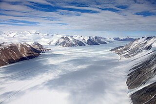
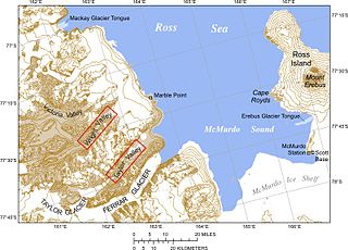
Ferrar Glacier is a glacier in Antarctica. It is about 35 nautical miles long, flowing from the plateau of Victoria Land west of the Royal Society Range to New Harbour in McMurdo Sound. The glacier makes a right (east) turn northeast of Knobhead, where it where it is apposed, i.e., joined in Siamese-twin fashion, to Taylor Glacier. From there, it continues east along the south side of Kukri Hills to New Harbor.

Makira-Ulawa Province is one of the nine provinces of Solomon Islands.
The Wilkniss Mountains form a prominent group of conical peaks and mountains, 10 nautical miles (19 km) long running north–south, located 9 nautical miles east-southeast of Mount Feather in the Quartermain Mountains, Victoria Land, Antarctica. The mountains are 3 nautical miles wide in the north portion where Mount Blackwelder, 2,340 metres (7,680 ft) high, and Pivot Peak 2,450 metres (8,040 ft) high, rise above ice-free valleys. Except for an outlying southwest peak, the south portion narrows to a series of mainly ice-covered smaller peaks.

Santa Isabel is the largest island in Isabel Province, Solomon Islands. It is also the longest island, with the third largest surface area, in the country.

Kirakira, also spelt Kira Kira, is the provincial capital of the Makira-Ulawa Province in Solomon Islands. Kirakira is located on the north coast of Makira, the largest island of the province. It has roads running 18 kilometres (11 mi) east to the Warihito River and 100 kilometres (62 mi) west to Maro'u Bay.
Sataoa is a small village situated on the central south coast of Upolu island in Samoa. Like many villages in the country, Sataoa has two settlements, one inland and one by the coast. The population of Sataoa Uta is 1121 and Sataoa Tai is 239.

Kirakira Airport is an airport located at Kirakira on the island of Makira, part of the Makira-Ulawa Province in the Solomon Islands. It is also known as Ngorangora Airstrip and was constructed in the late 1950s. The airport has scheduled flights provided by Solomon Airlines, using DHC-6 Twin Otter aircraft.

Ulawa Island is an island in Solomon Islands. It is located near Malaita Island and belongs to Makira-Ulawa Province. The island has an area of 65.92 square kilometres.

Pio Island is an island in Solomon Islands province of Makira-Ulawa. It is situated 4 km north-west of Ugi Island. It is 2.7 km long and 1.5 km wide. The estimated terrain elevation above sea level is some 227 metres. The island has no villages. Coral reef surrounds the island, which is largest in the west and south of the island.
Sterile Island is a 3.68 ha island game reserve in south-eastern Australia. It is part of the Actaeon Island Group, lying close to the south-eastern coast of Tasmania, at the southern entrance to the D'Entrecasteaux Channel between Bruny Island and the mainland.
Ali'ite is an island in Solomon Islands; it is the northern one of the Olu Malau Islands located in Makira-Ulawa Province. It has an area of 2.91 km2.
Malaulalo is an inhabited island in Solomon Islands; it is the central one of the Olu Malau Islands located in Makira-Ulawa Province. It has an area of 3.34 km2.
Malaupaina is an island in the nation state of Solomon Islands; it is the southern one of the Olu Malau Islands located in Makira-Ulawa Province. It has an area of 6.37 km2.

Ugi Island, also Uki Island or Uki Ni Massi, is an island 11 km north of the island of Makira, Makira-Ulawa Province in Solomon Islands, Pacific Ocean.

Fredriksen Island is an island 5 km (3.1 mi) long and 1 km (0.62 mi) wide, lying 1 km south-east of Powell Island in the South Orkney Islands of Antarctica. It was discovered by Captains Nathaniel Palmer and George Powell in the course of their joint cruise in December 1821. It was named by Norwegian whaling captain Petter Sorlle, who made a running survey of the island in the 1912–13 summer.

Mackay Glacier is a large glacier in Victoria Land, descending eastward from the Antarctic Plateau, between the Convoy Range and Clare Range, into the southern part of Granite Harbour. It was discovered by the South magnetic pole party of the British Antarctic Expedition, 1907–09, and named for Alistair Mackay, a member of the party. The glacier's tongue is called Mackay Glacier Tongue. First mapped by the British Antarctic Expedition, 1910–13 and named for Alistair F. Mackay, a member of the party. Its mouth is south of the Evans Piedmont Glacier and the Mawson Glacier. It is north of the Wilson Piedmont Glacier and the Ferrar Glacier.
Olu Malau Islands are islands of Makira-Ulawa Province of Solomon Islands. The estimated terrain elevation above sea level is 24 metres.
References
- ↑ Nunn, Patrick D. (2009). Vanished Islands and Hidden Continents of the Pacific. Honolulu: University of Hawaii Press. pp. 152–155, 201–204. ISBN 978-0-8248-3219-3.