
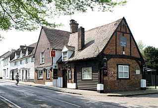
The Harrow is a pub at 22 Whitefriars Street, London.
It is a Grade II listed building, built in the early 18th century, and was originally two houses. [1]
The Harrow is a pub at 22 Whitefriars Street, London.
It is a Grade II listed building, built in the early 18th century, and was originally two houses. [1]

The Piccadilly line is a deep-level London Underground line running from the north to the west of London. It has two branches, which split at Acton Town, and serves 53 stations. The line serves Heathrow Airport, and some of its stations are near tourist attractions such as Piccadilly Circus and Buckingham Palace. The District and Metropolitan lines share some sections of track with the Piccadilly line. Printed in dark blue on the Tube map, it is the fourth busiest line on the Underground network, with over 210 million passenger journeys in 2011/12.
Harrow Garden Village was a housing development in the 1930s around Rayners Lane Underground station in London, England, which until then had been a "country halt" on the Metropolitan line. This was Metro-land's flagship development, begun in by E S Reid, with streets full of semi-detached houses fronted with bay windows and tiled roofs.
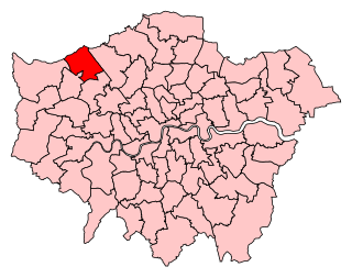
Harrow East is a constituency in Greater London created in 1945 and represented in the House of Commons of the UK Parliament since 2010 by Bob Blackman, a Conservative.

Harrow West is a constituency in Greater London created in 1945 and represented in the House of Commons of the UK Parliament. Until 1997, it only returned Conservative MPs; since then, it has elected the Labour Co-operative MP Gareth Thomas on a fluctuating majority. Since 2010, this has been bolstered by the loss of Pinner from the seat and the gain of a favourable ward for Labour from Harrow East.
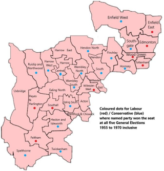
Harrow Central was a parliamentary constituency in Harrow, London, which returned one Member of Parliament (MP) to the House of Commons of the Parliament of the United Kingdom from 1950 until it was abolished for the 1983 general election.
The Headstone Museum, also known as the Harrow Museum, is the local history museum for the London Borough of Harrow in England.

Nower Hill High School is a secondary academy school with a sixth form, in Pinner in the London Borough of Harrow. The school currently has 324 students in each year group including over 400 in the Sixth form, making over 2000 students in the school. Students range from 11–19 years of age; the sixth form is part of the borough's Harrow Sixth Form Collegiate.

Harrow Central Mosque is a Sunni mosque and Islamic community hub in Harrow, England. The current centre opened in 2011 on no. 34 Station Road, adjacent to Harrow Civic Centre and a short distance south of Wealdstone town centre. The purpose-built facility was constructed as a replacement of a house-based mosque next to it, at no. 36 Station Road, which had been occupied by the mosque from 1985.

Stanmore Country Park is a 30.7-hectare (76-acre) public park, Local Nature Reserve and Site of Metropolitan Importance for Nature Conservation in Stanmore in the London Borough of Harrow. It is owned and managed by Harrow London Borough Council.

Stanmore Common is a 49.2-hectare public park, Local Nature Reserve and Site of Metropolitan Importance for Nature Conservation in Stanmore in the London Borough of Harrow in England. It is owned by Harrow Council and managed by the council with a local group. It was a biological Site of Special Scientific Interest, but was de-notified in the early 1990s.

Bentley Priory Nature Reserve is a Site of Special Scientific Interest and Local Nature Reserve in Stanmore in the London Borough of Harrow, surrounding the stately home of Bentley Priory. It is a 55 hectare mosaic of ancient woodland, unimproved neutral grassland, scrub, wetland, streams and an artificial lake, an unusual combination of habitats in Greater London.

Harrow Weald SSSI is a 3.7 hectare geological Site of Special Scientific Interest in Harrow Weald in the London Borough of Harrow. It was formerly part of the Stanmore and Harrow Weald Commons and Bentley Priory SSSI. It is a Geological Conservation Review site.

Northolt Manor is a 1.8 hectare scheduled monument, local nature reserve and Site of Borough Importance for Nature Conservation, Grade II, in Northolt in the London Borough of Ealing. It is owned and managed by Ealing Council.

The Harrow is a Grade II listed public house at Harrow Lane, Steep, Hampshire GU32 2DA.

Aberdeen Place is a street in St John's Wood, London. It was laid out after 1823 on the site of a farm once owned by the wealthy yeoman John Lyon, who founded Harrow School in 1571. The farm was located in the former Lisson Manor and was held by the governors of the school, with the proceeds going towards the maintenance of Harrow Road between Harrow and London. The farm was built over from 1823 onwards with the newly constructed streets being named after governors of Harrow School. In the case of Aberdeen Place, it was named after George Hamilton-Gordon, 4th Earl of Aberdeen, who had gone to school at Harrow and was Prime Minister from 1852 to 1855.

The Rose and Crown is a Grade II listed public house at 199 Stoke Newington Church Street, Stoke Newington, Hackney, London, N16 9ES.
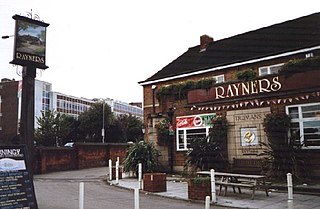
Rayners is a Grade II listed public house at 23 Village Way East, Rayners Lane, Harrow, London HA2 7LX.
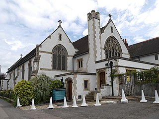
Our Lady and St Thomas of Canterbury is a Grade II listed Roman Catholic church at 22 Roxborough Park, Harrow-on-the-Hill, London.
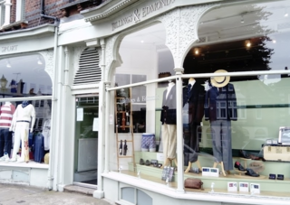
Billings and Edmonds is a British school uniform supplier. It was originally a gentlemen's tailor, and later changed its tailoring business towards the school uniform market. They operate an online business but also have High Street shops in Eton, Harrow on the Hill and Chiswick. The Harrow Branch, which serves Harrow School boys, until the 1980s was called Stevens, Billings & Edmonds when Billings & Edmonds incorporated the local Harrow tailor and other Harrow School outfitters, F.W.Stevens. Currently their Harrow branch has been renamed back to simply, 'Billings & Edmonds'. The first shop was in Princes Street, off Hanover Square, midway between the tailoring district of Savile Row and Regent Street. It claims to be founded in 1896, and accounts are extant from 1898- the current director Colin Edmonds is the fourth generation in the firm.
The Holly Bush is a listed building, formerly a public house, on the High Street, Elstree, Hertfordshire, England. Elstree's High Street was formerly an important main road, the A5 which followed the course of the Roman road Watling Street.
![]() Media related to The Harrow at Wikimedia Commons
Media related to The Harrow at Wikimedia Commons
51°30′47″N0°06′24″W / 51.512943°N 0.106758°W
| | This article about a London building or structure is a stub. You can help Wikipedia by expanding it. |
| | This pub-related article is a stub. You can help Wikipedia by expanding it. |