Thomas Carr Farmstead Site (Keeler Site RI-707) | |
| Nearest city | Jamestown, Rhode Island |
|---|---|
| Area | 0.2 acres (0.081 ha) |
| NRHP reference No. | 84000356 [1] |
| Added to NRHP | November 1, 1984 |
The Thomas Carr Farmstead Site (Keeler Site RI-707) is a historic archaeological site in Jamestown, Rhode Island. Located in the vicinity of Tashtassuc Road (the connector road paralleling Rhode Island Route 138) and Eldred Avenue, the site was the farmstead for the locally prominent Carr family from the late 18th century into the 19th century. [2]
The site added to the National Register of Historic Places in 1984. [1]

Jamestown is a town in Newport County, Rhode Island in the United States. The population was 5,559 at the 2020 census. Jamestown is situated almost entirely on Conanicut Island, the second largest island in Narragansett Bay. It also includes the uninhabited Dutch Island and Gould Island.
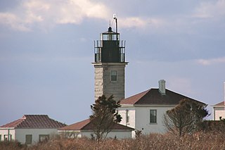
Beavertail Lighthouse was built in 1856 and is the premier lighthouse in Rhode Island, marking the entrance to Narragansett Bay. The 64-foot (20 m) lighthouse lies on the southernmost point of Conanicut Island in the town of Jamestown, Rhode Island in Beavertail State Park, on a site where beacons have stood since the early 18th century. The light provides navigation for boats and ships entering Narragansett Bay in the East Passage between Conanicut Island and Newport, Rhode Island on Aquidneck Island. Other lighthouses are visible from Beavertail Lighthouse, such as Castle Hill Lighthouse, Point Judith Light, and Rose Island Light.

The Smithfield Road Historic District is a rural historic district in North Smithfield, Rhode Island, along Old Smithfield Road. It extends along Old Smithfield Road north from its junction with Sayles Hill Road, and is roughly bisected by Spring Brook. It includes eight historic houses or farmsteads, two 19th-century cemeteries, and a dam on Spring Brook just east of the road. The district encompasses a cross-section of the development of agricultural properties in North Smithfield over the 19th century, with properties dating from 1811 to 1932. The district covers 170 acres (69 ha), which includes lands currently and formerly in agricultural use.

The William Whalley Homestead is an historic farmstead in Little Compton, Rhode Island. The main house is a 1+1⁄2-story wood-frame structure, probably built sometime between 1815 and 1830. The property includes a late 19th century gabled barn and a stone and wood outbuilding, and is bounded by a low stone wall. The main house is a fairly typical Cape style house, five bays wide, with a central chimney. The property as a whole is a well-preserved example of a typical 19th-century farmstead in the area.
The Windmill Hill Historic District is a historic district encompassing a large rural landscape in Jamestown, Rhode Island. It is bounded on the north by Eldred Avenue, on the east by East Shore Road, on the south by Great Creek, and on the west by Narragansett Bay. The area's historical resources included six farmsteads, as well as the Quaker Meetinghouse, the Jamestown Windmill, and its associated miller's house and barn. The area is predominantly rolling hills with open pastureland and forest. The district was listed on the National Register of Historic Places in 1978. The area is also rich in prehistoric evidence of Native American occupation, which is the subject of the Jamestown Archeological District listing on the National Register.
The Conanicut Battery is a colonial and 20th century military battery in Jamestown, Rhode Island, west of Beaver Tail Road. The site offers a commanding view of the West Passage of Narragansett Bay.

The Cook–Bateman Farm is a colonial-era farmstead located at the intersection of Fogland, Puncatest Neck and Pond Bridge Roads in Tiverton, Rhode Island. The property was initially purchased in 1700 and reached its largest size, 200 acres (81 ha), in the last 25 years of the 18th century. It currently encompasses 63 acres (25 ha) of rolling farmland.
The Jamestown Windmill is a smock mill in Jamestown, Rhode Island within the Windmill Hill Historic District on North Road north of Weeden Lane.
The Hazard Farmstead is a historic archaeological site in Jamestown, Rhode Island. It is the location of a major American Indian settlement whose artifacts have been dated from 2,500 BC to 1,000 AD. It appeared to be occupied seasonally from late summer to fall, and was intensively used during those times.
The Jamestown Archeological District is an expansive archaeological district which is the site of a major prehistoric Native American settlement in Jamestown, Rhode Island. The full extent of archaeologically-sensitive areas has not been fully identified, but is known to extend from Narragansett Avenue in the south to Rhode Island Route 138 in the north, and from Narragansett Bay in the west to North Road. The district overlaps the historically significant Windmill Hill Historic District, and the nearly 300-acre (120 ha) Watson Farm. The district includes one of largest Native American burying grounds in New England, and includes evidence of occupation dating to 3,000 BC.

The Dexter Arnold Farmstead is a historic farmstead on Chopmist Hill Road in Scituate, Rhode Island. The main house, a 2+1⁄2-story wood-frame structure five bays wide, with a large central chimney, was built in 1813. The 3.6-acre (1.5 ha) property also has five outbuildings which appear to be near contemporaries to the house, a relative rarity in rural Rhode Island. The main barn survived into the 20th century, but was destroyed by the New England Hurricane of 1938. The property also includes a small family cemetery. The house, built by Dexter Arnold in land belonging to his father, remained in family hands until 1975.
The Whipple–Cullen House and Barn is an historic farmstead on Old River Road in Lincoln, Rhode Island. The main house is a 2+1⁄2-story wood-frame structure, five bays wide, with a large central chimney and a gable roof. An addition extends to the rear, and a 19th-century porch is on the side of the house. The barn, dating to the late 19th century, is north of the house, and there is a former farm shed, now converted to a garage, to its south. The property is located across the street from the Lincoln town offices. The house, built c. 1740, is one of the town's least-altered 18th century houses, and the barn is a rare survivor of the town's agrarian past.
Black Farm, also known as the Isaac Collins Farm, is a historic farm in Hopkinton, Rhode Island bounded by Woodville Alton Road and Wood Road. The 264-acre (107 ha) plot was developed by John Collins beginning in 1710 and saw agricultural use for over 200 years. The main house dates to the late 18th century, and is a 1-1/2 story gambrel-roofed post-and-beam structure. Outbuildings include 19th century barns, a corn crib, and a guest cottage added in the 1930s. Set some distance off from this complex is the foundational remains of what was probably an ice house; it consists of granite blocks and is eight feet high.

The Crowfield Historic District is a small residential historic district in North Kingstown, Rhode Island. It encompasses a cluster of four early 20th-century summer houses, all connected via family or friendship connections to the writer Owen Wister. The occupy a large parcel of land sloping down to the shore of Narragansett Bay on the east side of Boston Neck Road, a short way north of the Jamestown Verrazzano Bridge. The area was named "Crowfield" by Elizabeth Middleton Cope, who built a Shingle-style mansion in 1906. Owen Wister, her uncle, built his house, Champ de Corbeau, in 1909-10 to a design by Grant Lafarge. The Jamieson House was also built in 1906, and was designed by the same architect, James P. Jamieson. The fourth house, Orchard House, was built in 1924. All are Shingle style houses. The compound is unusual for North Kingstown, where most summer estates were isolated individual properties.

The John Hoxsie House, also known as the Old Kenyon Farm, is an historic farmstead in Richmond, Rhode Island. The farm is a 60-acre (24 ha) parcel of land accessed via a long private drive on the east side of Richmond Town House Road, just north of Pinecrest Road, and is a rare, virtually intact, example of a 19th-century farmstead. The main house, a 1+1⁄2-story Cape style structure, was built in 1784 by John Hoxsie.

The Spink Farm is a historic farm at 1325 Shermantown Road in North Kingstown, Rhode Island. The only surviving element of the farmstead on this 55-acre (22 ha) farm is the main house, a 2+1⁄2-story five-bay wood-frame structure built in 1798 by Isaac Spink. The house exhibits modest Federal styling, its doorway flanked by small sidelight windows and simple pilasters, and topped by a shallow hood. The interior follows a typical center-chimney plan, with its original Federal period fireplace mantels intact. The house has been extended to the rear by a kitchen ell and porch, both added in the 20th century. The house is one of a small number of 18th-century farmsteads left in the town.

The Wilbor House is a historic house museum at 548 West Main Road in Little Compton, Rhode Island, and currently serves as the headquarters of the Little Compton Historical Society. The property includes eight buildings of historical significance, six of which were part of the Wilbor farmstead, a complex that was used for farming between 1690, when the east end of the house was built, and 1955, when the property was acquired by the historical society. The house is a 2½-story wood-frame structure, whose oldest portion was probably a stone ender built by Samuel Wilbor, and whose western half was added c.1740, giving it a Georgian appearance. Two ells were added c.1860, and additiona expansions were made in 1967. The five farm outbuildings include an 18th-century outhouse, a c.1800 barn, and corn crib and carriage house, both of which were built c.1850. Two additional non-contributing structures are on the property, the frame of a c.1750 barn covered in modern materials, and a modern replica of an 18th-century schoolhouse.

The Shoreby Hill Historic District encompasses a major residential subdivision north of the central business district of Jamestown, Rhode Island. The 58-acre (23 ha) district was farmland until the late 19th century, and was laid out in two phases. The first, in 1898 includes the lower portion of the area, rising from the shore of Jamestown Harbor; the upper portion was laid out in 1911. The lower portion's layout is in part determined by its hill topography, with winding roads, while the upper portion has a more rectilinear grid street pattern. The district is roughly bounded on the east by Jamestown Harbor, on the north by Emerson Road, Prudence Lane, and Whittier Road, on the west by Plymouth Road, and Coronado Street, and on the south by Knowles Court. The area was designed by Ernest W. Bowditch as an exclusive and fashionable summer resort area, with larger houses on well-proportioned lots. The ninety houses in the district are predominantly shingle style.

The Spencer–Shippee–Lillbridge House, also known as the Crossways Farm and Walnut Brook Farm, is a historic farmstead at 12 Middle Road in East Greenwich, Rhode Island. The main house is a 2+1⁄2-story timber-frame structure, five bays wide and three bays deep, whose construction date is traditionally given as 1772. There is, however, architectural evidence that it may be older. The building has a small 19th century addition, whose purpose was to provide a staircase for hired farmhands to reach the attic, where their living space was. The downstairs spaces have retained much of their original Georgian fabric, although a pantry space has been converted into a modern kitchen. There are five outbuildings on the 1.3-acre (0.53 ha) property, including a 19th-century wagon shed and horse barn. The house, once the centerpiece of a 225-acre (91 ha) farm, was held by members of the interrelated Spencer, Shippee, and Lillbridge families from its inception until 2001.
Carr House may refer to:
| Topics | |
|---|---|
| Lists by state |
|
| Lists by insular areas | |
| Lists by associated state | |
| Other areas | |
| Related | |