Thomson, Minnesota

Last updated

Thomson
Former city
Town of Thomson.jpg
Town of Thomson sign
Carlton County Minnesota Incorporated and Unincorporated areas Thomson Highlighted.svg
Location of the city of Thomson
within Carlton County, Minnesota
Coordinates: 46°39′55″N92°23′44″W / 46.66528°N 92.39556°W / 46.66528; -92.39556
Country United States
State Minnesota
County Carlton
Area
[1]
  Total2.23 sq mi (5.78 km2)
  Land1.87 sq mi (4.84 km2)
  Water0.36 sq mi (0.93 km2)
Elevation
1,053 ft (321 m)
Population
 (2010) [2]
  Total159
  Estimate 
(2012 [3] )
158
  Density85.0/sq mi (32.8/km2)
Time zone UTC-6 (Central (CST))
  Summer (DST) UTC-5 (CDT)
FIPS code 27-64750 [4]
GNIS feature ID0653168 [5]

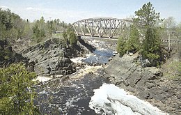
Thomson was a city in Carlton County, Minnesota, United States, located along the Saint Louis River. The population was 159 at the 2010 census. [6]

Contents

On November 5, 2013, a vote to authorize the consolidation of Thomson and nearby Carlton passed with a 95% approval.

Thomson is adjacent to Jay Cooke State Park and is located on the Willard Munger State Trail.

Minnesota Highway 210 and Dalles Avenue are two of the main routes in the community.

Thomson is located seven miles southeast of the city of Cloquet; and 18 miles southwest of the city of Duluth.

History

Thomson was founded in 1870, and named for David Thompson, a Canadian explorer and surveyor. [7] A post office was established at Thomson in 1870, and remained in operation until it was discontinued in 1955. [8]

Geography

The Saint Louis River in Thomson St Louis River.jpg
The Saint Louis River in Thomson

According to the United States Census Bureau, the city has a total area of 2.23 square miles (5.78 km2), of which 1.87 square miles (4.84 km2) is land and 0.36 square miles (0.93 km2) is water. [1]

Demographics

Historical population
CensusPop.Note
1900 207
1910 169−18.4%
1920 103−39.1%
1930 76−26.2%
1940 10436.8%
1950 17063.5%
1960 1795.3%
1970 159−11.2%
1980 152−4.4%
1990 132−13.2%
2000 15315.9%
2010 1593.9%
2014 (est.)158 [9] −0.6%
U.S. Decennial Census [10]

2010 census

As of the census [2] of 2010, there were 159 people, 73 households, and 48 families living in the city. The population density was 85.0 inhabitants per square mile (32.8/km2). There were 76 housing units at an average density of 40.6 per square mile (15.7/km2). The racial makeup of the city was 96.9% White, 1.3% Native American, 0.6% Asian, 0.6% from other races, and 0.6% from two or more races.

There were 73 households, of which 21.9% had children under the age of 18 living with them, 60.3% were married couples living together, 1.4% had a female householder with no husband present, 4.1% had a male householder with no wife present, and 34.2% were non-families. 28.8% of all households were made up of individuals, and 8.2% had someone living alone who was 65 years of age or older. The average household size was 2.18 and the average family size was 2.69.

The median age in the city was 48.2 years. 17% of residents were under the age of 18; 4.4% were between the ages of 18 and 24; 23.9% were from 25 to 44; 35.9% were from 45 to 64; and 18.9% were 65 years of age or older. The gender makeup of the city was 48.4% male and 51.6% female.

2000 census

As of the census of 2000, [4] there were 153 people, 64 households, and 44 families living in the city. The population density was 81.3 inhabitants per square mile (31.4/km2). There were 67 housing units at an average density of 35.6 per square mile (13.7/km2). The racial makeup of the city was 97.39% White, 0.65% Native American, and 1.96% from two or more races. 21.9% were of Irish, 20.2% Finnish, 15.8% Norwegian, 14.0% German, 8.8% Polish and 7.0% Swedish ancestry.

There were 64 households, out of which 25.0% had children under the age of 18 living with them, 62.5% were married couples living together, 6.3% had a female householder with no husband present, and 29.7% were non-families. 26.6% of all households were made up of individuals, and 10.9% had someone living alone who was 65 years of age or older. The average household size was 2.39 and the average family size was 2.89.

In the city, the population was spread out, with 18.3% under the age of 18, 9.2% from 18 to 24, 28.1% from 25 to 44, 31.4% from 45 to 64, and 13.1% who were 65 years of age or older. The median age was 41 years. For every 100 females, there were 109.6 males. For every 100 females age 18 and over, there were 123.2 males.

The median income for a household in the city was $48,438, and the median income for a family was $65,833. Males had a median income of $48,750 versus $31,250 for females. The per capita income for the city was $24,290. About 4.8% of families and 5.7% of the population were below the poverty line, including none of those under the age of eighteen and 22.2% of those 65 or over.

See also

46°39′49″N92°23′53″W / 46.66361°N 92.39806°W / 46.66361; -92.39806

Related Research Articles

<span class="mw-page-title-main">Osceola, Indiana</span> Town in Indiana, United States

Osceola is a town in Penn Township, St. Joseph County, in the U.S. state of Indiana. The population was 2,463 at the 2010 Census. It is part of the South Bend–Mishawaka, IN-MI, Metropolitan Statistical Area.

<span class="mw-page-title-main">Ramsey, Minnesota</span> City in Minnesota, United States

Ramsey is a suburban city 22 miles (35 km) north-northwest of downtown Minneapolis in Anoka County, Minnesota, United States. The population was 27,646 at the 2020 census. It is a northwest suburb of the Twin Cities.

<span class="mw-page-title-main">Barnum, Minnesota</span> City in Minnesota, United States

Barnum is a city in Carlton County, Minnesota, United States. The population was 613 at the 2010 census.

<span class="mw-page-title-main">Carlton, Minnesota</span> City in Minnesota, United States

Carlton is a city in Carlton County, Minnesota, United States. The population was 948 at the 2020 census. It is the county seat of Carlton County. The town sits on the northwestern edge of Jay Cooke State Park.

Lakeview Township is a township in Carlton County, Minnesota, United States. The population was 194 as of the 2000 census. Lakeview Township was so named by early settlers from their scenic views over Tamarack Lake and other lakes.

Thomson Township is a township in Carlton County, Minnesota, United States. The population was 5,003 as of the 2010 census. Thomson Township took its name from the city of Thomson.

<span class="mw-page-title-main">Emily, Minnesota</span> City in Minnesota, United States

Emily is a city in Crow Wing County, Minnesota, United States. The population was 813 at the 2010 census. It is part of the Brainerd Micropolitan Statistical Area.

<span class="mw-page-title-main">Clitherall, Minnesota</span> City in Minnesota, United States

Clitherall is a city in Otter Tail County, Minnesota, United States. The population was 62 at the 2020 census.

<span class="mw-page-title-main">Deer Creek, Minnesota</span> City in Minnesota, United States

Deer Creek is a city in Otter Tail County, Minnesota, United States. The population was 330 at the 2020 census.

<span class="mw-page-title-main">Erhard, Minnesota</span> City in Minnesota, United States

Erhard is a city in Otter Tail County, Minnesota, United States. The population was 132 at the 2020 census.

<span class="mw-page-title-main">Henning, Minnesota</span> City in Minnesota, United States

Henning is a city in Otter Tail County, Minnesota, United States. The population was 854 at the 2020 census.

<span class="mw-page-title-main">Ottertail, Minnesota</span> City in Minnesota, United States

Ottertail is a city in Otter Tail County, Minnesota, United States. The population was 629 at the 2020 census.

<span class="mw-page-title-main">Richville, Minnesota</span> City in Minnesota, United States

Richville is a city in Otter Tail County, Minnesota, United States. The population was 77 as of the 2020 census.

<span class="mw-page-title-main">Fifty Lakes, Minnesota</span> City in Minnesota, United States

Fifty Lakes is a city in Crow Wing County, Minnesota, United States. The population was 387 at the 2010 census. It is part of the Brainerd Micropolitan Statistical Area.

<span class="mw-page-title-main">Pymatuning North, Pennsylvania</span> Census-designated place in Pennsylvania, United States

Pymatuning North is a census-designated place (CDP) in Crawford County, Pennsylvania, United States. The population was 311 at the 2010 census.
<span class="mw-page-title-main">Gantt, South Carolina</span> Census-designated place in South Carolina, United States

Gantt is a census-designated place (CDP) in Greenville County, South Carolina, United States. The population was 14,229 at the 2010 census. It is part of the Greenville–Mauldin–Easley Metropolitan Statistical Area and a suburb of the city of Greenville.

<span class="mw-page-title-main">Riverside, Texas</span> City in Texas, United States

Riverside is a small city in Walker County, Texas, United States. The population was 522 at the 2020 census. Two famous natives of Riverside are the singer-actress Jennifer Holliday, who is best known for her creation of the role of Effie in the successful Tony-award-winning Broadway musical "Dreamgirls", and Eugene C. Barker, a Texas historian, who was affiliated with the University of Texas at Austin from 1895, when he arrived as a student, until his death.

<span class="mw-page-title-main">South Bend, Washington</span> City in Washington, United States

South Bend is a city in and the county seat of Pacific County, Washington, United States. The population was 1,637 as of the 2010 census. The town is widely-known for its oyster production and scenery.

Arbor Vitae is a town in Vilas County, Wisconsin, United States. The population was 3,153 at the 2000 census. The unincorporated community of Arbor Vitae is located in the town.

<span class="mw-page-title-main">Minnesota Lake, Minnesota</span> City in Minnesota, United States

Minnesota Lake is a city in Blue Earth and Faribault counties in the State of Minnesota. The population was 661 at the 2020 census. The bulk of the city is in Faribault County; a small part extends into Blue Earth County.

References

  1. 1 2 "US Gazetteer files 2010". United States Census Bureau. Archived from the original on January 25, 2012. Retrieved November 13, 2012.
  2. 1 2 "U.S. Census website". United States Census Bureau . Retrieved November 13, 2012.
  3. "Population Estimates". United States Census Bureau. Archived from the original on June 11, 2013. Retrieved May 28, 2013.
  4. 1 2 "U.S. Census website". United States Census Bureau . Retrieved January 31, 2008.
  5. "US Board on Geographic Names". United States Geological Survey. October 25, 2007. Retrieved January 31, 2008.
  6. "2010 Census Redistricting Data (Public Law 94-171) Summary File". American FactFinder. U.S. Census Bureau, 2010 Census. Retrieved April 23, 2011.[ dead link ]
  7. Upham, Warren (1920). Minnesota Geographic Names: Their Origin and Historic Significance. Minnesota Historical Society. p.  76.
  8. "Carlton County". Jim Forte Postal History. Retrieved April 11, 2015.
  9. "Annual Estimates of the Resident Population for Incorporated Places: April 1, 2010 to July 1, 2014". Archived from the original on May 23, 2015. Retrieved June 4, 2015.
  10. "Census of Population and Housing". Census.gov. Retrieved June 4, 2015.