A petroglyph is an image created by removing part of a rock surface by incising, picking, carving, or abrading, as a form of rock art. Outside North America, scholars often use terms such as "carving", "engraving", or other descriptions of the technique to refer to such images. Petroglyphs, estimated to be 20,000 years old are classified as protected monuments and have been added to the tentative list of UNESCO's World Heritage Sites. Petroglyphs are found worldwide, and are often associated with prehistoric peoples. The word comes from the Greek prefix petro-, from πέτρα petra meaning "stone", and γλύφω glýphō meaning "carve", and was originally coined in French as pétroglyphe.
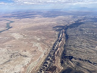
The San Rafael Swell is a large geologic feature located in south-central Utah, United States about 16 miles (26 km) west of Green River. The San Rafael Swell, measuring approximately 75 by 40 miles, consists of a giant dome-shaped anticline of sandstone, shale, and limestone that was pushed up during the Paleocene Laramide Orogeny 60–40 million years ago. Since that time, infrequent but powerful flash floods have eroded the sedimentary rocks into numerous valleys, canyons, gorges, mesas, buttes, and badlands.

Sloan Canyon National Conservation Area is a National Conservation Area (NCA) administered by the United States Bureau of Land Management (BLM). It includes the Sloan Petroglyph Site which was listed on the National Register of Historic Places on December 19, 1978. It is located south of Henderson, Nevada, access is available from Las Vegas Boulevard, near the Del Webb Anthem development in Henderson. Sloan Canyon NCA protects 48,438 acres (19,602 ha).
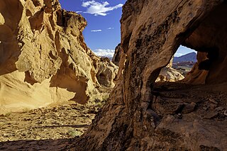
The Paria Canyon-Vermilion Cliffs Wilderness is a 112,500 acres (455 km2) wilderness area located in northern Arizona and southern Utah, United States, within the arid Colorado Plateau region. The wilderness is composed of broad plateaus, tall escarpments, and deep canyons.

Agua Fria National Monument is in the U.S. state of Arizona, approximately 40 miles (64 km) north of downtown Phoenix, Arizona. Created by Presidential proclamation on January 11, 2000, the 72,344-acre monument is managed by the Bureau of Land Management, an agency within the U.S. Department of the Interior. The Bureau of Land Management already managed the lands; however, under monument status the level of protection and preservation of resources within the new monument have been enhanced.

Ironwood Forest National Monument is located in the Sonoran Desert of Arizona. Created by Bill Clinton by Presidential Proclamation 7320 on June 9, 2000, the monument is managed by the Bureau of Land Management, an agency within the United States Department of the Interior. The monument covers 129,055 acres (52,227 ha), of which 59,573 acres (24,108 ha) are non-federal and include private land holdings and Arizona State School Trust lands.

Otero Mesa is a plateau in the Trans-Pecos. The plateau extends north from Hudspeth County, Texas into Otero County, New Mexico. Otero Mesa is the dominant landform in Hudspeth County, composing 70% of its land area. Otero Mesa has a more limited extant in Otero County, NM. Overall, 2/3 of Otero Mesa are in Texas, but the colloquial usage of "Otero Mesa" is restricted to the component of the plateau in New Mexico. This is only a political distinction; Otero Mesa is physiographically continuous across the NM-TX state line.

The Grapevine Canyon Petroglyphs are located in Grapevine Canyon on Spirit Mountain near Laughlin, Nevada, and are listed on the United States National Register of Historic Places. The area is also known as Christmas Tree Pass. While the petroglyphs extend through the canyon, a significant concentration lies at the entrance to the canyon which is at an elevation of 2,395 feet (730 m). The area features over 700 petroglyphs and many rock shelters.

Coso Rock Art District is a rock art site containing over 100,000 Petroglyphs by Paleo-Indians and/or Native Americans. The district is located near the towns of China Lake and Ridgecrest, California. Big and Little Petroglyph Canyons were declared a National Historic Landmark in 1964. In 2001, they were incorporated into this larger National Historic Landmark District. There are several other distinct canyons in the Coso Rock Art District besides the Big and Little Petroglyph Canyons. Also known as Little Petroglyph Canyon and Sand Tanks, Renegade Canyon is but one of several major canyons in the Coso Range, each hosting thousands of petroglyphs. The majority of the Coso Range images fall into one of six categories: bighorn sheep, entopic images, anthropomorphic or human-like figures, other animals, weapons & tools, and "medicine bag" images. Scholars have proposed a few potential interpretations of this rock art. The most prevalent of these interpretations is that they could have been used for rituals associated with hunting.
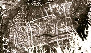
Big and Little Petroglyph Canyons are two principal landforms within which are found major accumulations of Paleo-Indian and/or Native American Petroglyphs, or rock art, by the Coso People located in the Coso Range Mountains of the northern Mojave Desert, and now within the Naval Air Weapons Station China Lake, near the towns of China Lake and Ridgecrest, California. Little Petroglyph Canyon contains 20,000 documented images, which surpasses in number for most other collections. Additionally, the archeological resources are remarkably undisturbed.

Areas of Critical Environmental Concern (ACEC) is a conservation ecology program in the Western United States, managed by the Bureau of Land Management (BLM). The ACEC program was conceived in the 1976 Federal Lands Policy and Management Act (FLPMA), which established the first conservation ecology mandate for the BLM. The FLPMA mandate directs the BLM to protect important riparian corridors, threatened and endangered species habitats, cultural and archeological resources, as well as unique scenic landscapes that the agency assesses as in need of special management attention.
Wyoming straddles the Continental Divide, and its abrupt topographic relief includes alternating basins and mountain ranges. Major mountain ranges include the Beartooth, Gros Ventre, Teton, Wind River, Bighorn, Sierra Madre, and Medicine Bow. Internal basins and eastern plains are rolling to flat, and in the east are the Great Plains.

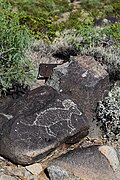
The Painted Rock Petroglyph Site is a collection of hundreds of ancient petroglyphs near the town of Theba, Arizona, United States, listed on the National Register of Historic Places in 1977. The site is operated and maintained by the Bureau of Land Management (BLM), and includes an improved campground as well as an informative walking trail showcasing the petroglyphs.

The Santa Rosa Wilderness is a 72,259-acre (292.42 km2) wilderness area in Southern California, in the Santa Rosa Mountains of Riverside and San Diego counties, California. It is in the Colorado Desert section of the Sonoran Desert, above the Coachella Valley and Lower Colorado River Valley regions in a Peninsular Range, between La Quinta to the north and Anza Borrego Desert State Park to the south. The United States Congress established the wilderness in 1984 with the passage of the California Wilderness Act, managed by both the US Forest Service and the Bureau of Land Management. In 2009, the Omnibus Public Land Management Act was signed into law which added more than 2,000 acres (8.1 km2). Most of the Santa Rosa Wilderness is within the Santa Rosa and San Jacinto Mountains National Monument.
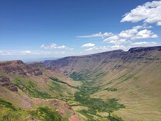
Kiger Creek is a tributary of Swamp Creek in Harney County in the U.S. state of Oregon. It originates on Steens Mountain and flows generally north through Kiger Gorge to meet Swamp Creek near the unincorporated community of Diamond. The combined streams flow into Diamond Swamp and the Malheur National Wildlife Refuge.

The Rio Grande del Norte National Monument is an approximately 242,555-acre (98,159 ha) area of public lands in Taos County, New Mexico, United States, proclaimed as a national monument on March 25, 2013, by President Barack Obama under the provisions of the Antiquities Act. It consists of the Rio Grande Gorge and surrounding lands, managed by the Bureau of Land Management (BLM).

Sand to Snow National Monument is a U.S. National Monument located in San Bernardino County and northern Riverside County, Southern California.
Gold Butte National Monument is a United States national monument located in Clark County, Nevada, northeast of Las Vegas and south of Mesquite and Bunkerville. The monument protects nearly 300,000 acres of desert landscapes featuring a wide array of natural and cultural resources, including rock art, sandstone towers, and important wildlife habitat for species including the Mojave Desert tortoise, bighorn sheep, and mountain lion. The area also protects historic ranching and mining sites such as the ghost town of Gold Butte, although little but mine openings, cement foundations, and a few pieces of rusting equipment remains. The monument is managed by the Bureau of Land Management.

The Sabinoso Wilderness is a 29,855 acres (120.82 km2) area in San Miguel County, New Mexico. The US Bureau of Land Management owns and administers the wilderness area. The semi-arid wilderness includes few natural resources but has a diverse geology, as well as a range of plant and animal species.

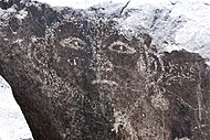
The Thompson Wash Rock Art District, known by the Bureau of Land Management as the Sego Canyon Rock Art Interpretive Site, is a rock art site in Grand County, Utah, north of the town of Thompson Springs. It contains art from three different cultures: the Fremont, the Ute, and the Barrier Canyon Style.