
Darling Harbour is a harbour adjacent to the city centre of Sydney, New South Wales, Australia that is made up of a large recreational and pedestrian precinct that is situated on western outskirts of the Sydney central business district.

Port Jackson, consisting of the waters of Sydney Harbour, Middle Harbour, North Harbour and the Lane Cove and Parramatta Rivers, is the ria or natural harbour of Sydney, New South Wales, Australia. The harbour is an inlet of the Tasman Sea. It is the location of the Sydney Opera House and Sydney Harbour Bridge. The location of the first European settlement and colony on the Australian mainland, Port Jackson has continued to play a key role in the history and development of Sydney.
Woolloomooloo is a harbourside, inner-city eastern suburb of Sydney, New South Wales, Australia, 1.5 kilometres east of the central business district, in the local government area of the City of Sydney. It is in a low-lying, former docklands area at the head of Woolloomooloo Bay, on Sydney Harbour. The Domain sits to the west, the locality of East Sydney is near the south-west corner of the suburb and the locality of Kings Cross is near the south-east corner. Potts Point is immediately to the east.

Milsons Point is a suburb on the lower North Shore of Sydney, in the state of New South Wales, Australia. The suburb is located 3 kilometres north of the Sydney central business district in the local government area of North Sydney Council.
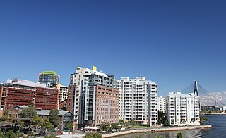
Pyrmont is an inner-city suburb of Sydney, in the state of New South Wales, Australia 2 kilometres south-west of the Sydney central business district in the local government area of the City of Sydney. It is also part of the Darling Harbour region. As of 2011, it is Australia's most densely populated suburb.
David Kang is an Australian barrister. In 1994, he fired two blank shots from a starting pistol at Charles, Prince of Wales in protest of the treatment of several hundred Cambodian asylum seekers held in detention camps in Australia.

Darling Point is a harbourside eastern suburb of Sydney, Australia. It is 4 kilometres east of the Sydney central business district and is part of the local government area of Woollahra Council.

Cabarita is a bayside suburb in the Inner West of Sydney, in the state of New South Wales, Australia. Cabarita is located 16 kilometres west of the Sydney central business district, in the local government area of the City of Canada Bay.

The Chinese Garden of Friendship is a heritage-listed 1.03-hectare (3-acre) Chinese garden at 1 Harbour Street, in the Sydney Central Business District, City of Sydney, New South Wales, Australia. Modelled after the classic private gardens of the Ming dynasty, the garden offers an insight into Chinese heritage and culture. It was designed by Guangzhou Garden Planning & Building Design Institute, Tsang & Lee, and Edmond Bull & Corkery. It was built between 1986-1988 by Gutteridge Haskins & Davey, the Darling Harbour Authority, Imperial Gardens, Leightons, and Australian Native Landscapes. The gardens were added to the New South Wales State Heritage Register on 5 October 2018.

Tourism in Sydney forms an important part of the city's economy. The city received 12 million domestic visitors and 4.1 million international visitors in year ending June 2019. The most famous attractions include the Sydney Opera House, and the Sydney Harbour Bridge. Other attractions include the Sydney Mardi Gras, Royal Botanical Gardens, Luna Park, the beaches and Sydney Tower.

Milsons Point ferry wharf is located on the northern side of Sydney Harbour serving the Sydney suburb of Milsons Point. It is next to Luna Park and the Sydney Harbour Bridge. It is served by Sydney Ferries Parramatta River and Pyrmont Bay services operated by First Fleet and RiverCat class ferries.

Cockle Bay is a small bay in inner-city Sydney, New South Wales, Australia. It is located on the western edge of the Sydney central business district.

Balmain East ferry wharf is located on Sydney Harbour serving the Sydney suburb of Balmain East.

Barangaroo is an area of central Sydney, Australia. It is at the north-western edge of the Sydney central business district and the southern end of the Sydney Harbour Bridge. It is part of the local government area of the City of Sydney. The area was used for fishing and hunting by Indigenous Australians prior to colonial settlement. The area is inclusive of The Hungry Mile, the name harbourside workers gave to the docklands area of Darling Harbour East during The Great Depression, where workers would walk from wharf to wharf in search of a job, often failing to find one.

Pyrmont Bay ferry wharf is located on the western side of Darling Harbour serving the inner-city Sydney suburb of Pyrmont. It is located adjacent to the Australian National Maritime Museum and close to The Star Casino.
The Real Insurance Sydney Harbour 10k is an Australian 10 km road race, held annually in Sydney, Australia. The event is certified accurate and is approved by the Association of International Marathons and Distance Races (AIMS).
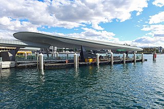
Barangaroo ferry wharf is a ferry wharf located on the eastern side of Darling Harbour, in Sydney, Australia. The wharf is the major public transport link of the Barangaroo precinct, situated west of the Sydney central business district. The complex consists two wharves, with provision for a third wharf in the future. It is serviced by Sydney Ferries' F3 Paramatta River and F4 Pyrmont Bay services. It opened on 26 June 2017.

The Pyrmont Bay ferry service, officially known as F4 Pyrmont Bay, is a commuter ferry service in Sydney, New South Wales. Part of the Sydney Ferries network, it is operated by Transdev Sydney Ferries and services the Lavender Bay and Darling Harbour areas. It began operation on 25 October 2020, and replaced the western half of the F4 Cross Harbour ferry service. Emerald-class ferries and SuperCat ferries operate the service.

The Royal Edward Victualling Yard (REVY) is a heritage-listed former naval victualling yard and warehouses, in the inner city Sydney suburb of Pyrmont in the City of Sydney local government area of New South Wales, Australia. It was designed by Walter Liberty Vernon and built from 1904 to 1912 by McLeod Brothers and NSW Public Works Department. The buildings are also known as Buildings A & B: REVY Main Warehouse, Naval Warehouse and Royal Edward Victualling Yard, Building C: Former Commonwealth Ordnance Stores. The property was added to the New South Wales State Heritage Register on 22 March 2011.
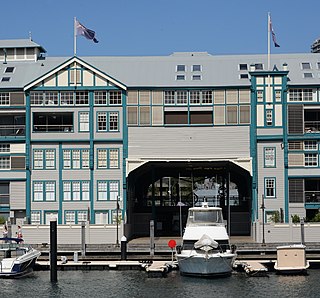
Jones Bay Wharf is a historically important wharf on Jones Bay, a small bay at Pyrmont, Sydney, New South Wales. The wharf was completed in 1919, and in the 21st century has been converted to modern business spaces.

