The National Register of Historic Places (NRHP) is the United States federal government's official list of districts, sites, buildings, structures and objects deemed worthy of preservation for their historical significance. A property listed in the National Register, or located within a National Register Historic District, may qualify for tax incentives derived from the total value of expenses incurred in preserving the property.

Derby ('dər-bē) is a city in New Haven County, Connecticut, United States, approximately 8 miles west-northwest of New Haven. It is located in southwest Connecticut at the confluence of the Housatonic and Naugatuck Rivers. It borders the cities of Ansonia to the north and Shelton to the southwest, and the towns of Orange to the south, Seymour to the northwest, and Woodbridge to the east. The population was 12,325 at the 2020 census. It is the smallest city in Connecticut by area, at 5.3 square miles.

Westport is a town in Fairfield County, Connecticut, United States, along the Long Island Sound within Connecticut's Gold Coast. It is 52 miles (84 km) northeast of New York City. The town had a population of 27,141 according to the 2020 U.S. Census.
The Merritt Parkway is a limited-access parkway in Fairfield County, Connecticut, with a small section at the northern end in New Haven County. Designed for Connecticut's Gold Coast, the parkway is known for its scenic layout, its uniquely styled signage, and the architecturally elaborate overpasses along the route. As one of the first, oldest parkways in the United States, it is designated as a National Scenic Byway and is also listed in the National Register of Historic Places. Signed as part of Route 15, it runs from the New York state line in Greenwich, where it serves as the continuation of the Hutchinson River Parkway, to Exit 54 in Milford, where the Wilbur Cross Parkway begins. Facing bitter opposition, the project took six years to build in three different sections, with the Connecticut Department of Transportation constantly requiring additional funding due to the area's high property value. The parkway was named for U.S. Congressman Schuyler Merritt. In 2010, the National Trust for Historic Preservation called the Merritt Parkway one of "America's 11 Most Endangered Historic Places".

This is intended to be a complete list of the properties and districts on the National Register of Historic Places in Fairfield County, Connecticut, United States. The locations of National Register properties and districts for which the latitude and longitude coordinates are included below may be seen in an online map.

This is a list of the National Register of Historic Places listings in New Haven County, Connecticut.

This is a list of the National Register of Historic Places listings in Tolland County, Connecticut.

This is a list of the National Register of Historic Places listings in St. Louis County, Missouri.

This is a list of properties on the National Register of Historic Places in Hartford, Connecticut.
This is a list of the National Register of Historic Places listings in Olmsted County, Minnesota. It is intended to be a complete list of the properties and districts on the National Register of Historic Places in Olmsted County, Minnesota, United States. The locations of National Register properties and districts for which the latitude and longitude coordinates are included below, may be seen in an online map.
The Kings Highway North Historic District is a predominantly residential 58-acre (23 ha) historic district in Westport, Connecticut. Located on the hillside west of the Saugatuck River, this area encapsulates architecturally several major stages in the community's development, from colonial days to the 20th century. It was listed on the National Register of Historic Places in 1998.

The United States Post Office is a former post office building at 310 Greenwich Avenue in downtown Greenwich, Connecticut. Built in 1915, it is a good example of Classical Revival architecture, with a distinctive plan predating the Postal Service's standardization of buildings. It was listed on the National Register of Historic Places in 1986. It was included in the Greenwich Municipal Center Historic District which was listed in 1988, and is also included in the Greenwich Avenue Historic District. The building is now in commercial retail use.
The Old Town Hall is a historic former municipal building at 90 Post Road East in Westport, Connecticut. Built in 1908 as the town's first purpose-built municipal office building, it is unusual architecturally for using cobblestones within a design that is, overall, Classical Revival in style. In 1979 Westport moved its municipal offices to a rehabilitated grade school building at 110 Myrtle Avenue, Westport, CT 06880.
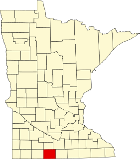
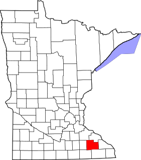
This is a list of the National Register of Historic Places listings in Martin County, Minnesota. It is intended to be a complete list of the properties and districts on the National Register of Historic Places in Martin County, Minnesota, United States. The locations of National Register properties and districts for which the latitude and longitude coordinates are included below, may be seen in an online map.
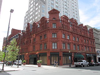
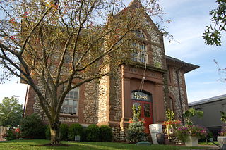
The Goodwin Hotel, is a historic hotel and apartment building located in downtown Hartford, Connecticut. Known for its distinctive English Queen Anne terracotta facade, the building was originally developed as an apartment building by brothers James J. Goodwin and Rev. Francis Goodwin and opened in 1881. It was designed by Francis Kimball and was modeled on buildings Rev. Goodwin had seen being constructed at the time in England. Kimball, of the firm of Kimball & Wisedell, was the architect for the Day House in Hartford, which also has an English Queen Anne design. The Goodwin Building was expanded in 1891 to Ann Street and in 1900 to Pearl Street. It was a very prestigious address at the time, with even J.P. Morgan living there during his visits to the city of his birth.


