Energy Production
| | This section is empty. You can help by adding to it. (December 2023) |
| Upper Pope Group | |
|---|---|
| Stratigraphic range: Carboniferous | |
| Type | Geological group |
| Sub-units |
|
| Overlies | Lower Pope Group |
| Lithology | |
| Primary | Sandstone, Limestone, Shale |
| Location | |
| Region | Illinois Basin |
| Country | United States of America |
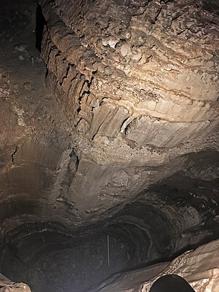
The Upper Pope Group is a geologic unit found in the Illinois Basin of southern Illinois, southwestern Indiana, and western Kentucky. [1] [2] In Indiana and Kentucky its equitant is the Buffalo Wallow Group. This unit grades from sandstones at its base into mix of limestones and sandstone and then a shale at its top. [3] In Sothern Illinois oil wells are drilled into the Tar Springs formation. [4]
Also known at the Kinkaid Limestone, this unit is made up of several smaller members. This unit ranges from 0' - 230 ' thick. The Grove Church Shale is at the top, followed by Members, Goreville Limestone, Cave Hill Shale, and Negli Creek Limestone.
A formation in Illinois containing 4 members that are linked to other formations in the Upper Pope Group. The Negli Creek Limestone of the Kinkaid formation to the west. Mt. Pleasant Sandstone, Bristow Sandstone, and Siberia Limestone. The Siberia is a thin tongue of the Menard formation. [5]
This sandstone unit is 0-150' thick.
This unit is 0-150’ thick. Its units include the Ford Station Limestone, Tygett Sandstone and Cora Limestone Members.
This sandstone unit is 0-120' thick.
The Menard Limestone is a geologic formation in the Illinois Basin of southern Illinois, southwestern Indiana, and western Kentucky.
The type section of both the Walche Limestone Member and the Scottsburg Limestone Member are exposures in Walche's Cut, a railway cutting on the Illinois Central Railroad. [6] [7] [8]
This formation is 0-100’ thick.
This limestone unit is 0-60' thick
This sandstone unit is 0-150' thick. The Tar Springs consists of interbedded sandstone and shale, creating closed reservoirs within the sand. For this reason it is the largest oil producing formation in Illinois. Estimated to have accounted for more than 60% of the oil production in the state.
| | This section is empty. You can help by adding to it. (December 2023) |

The Permian Basin is a large sedimentary basin in the southwestern part of the United States. It is the highest producing oil field in the United States, producing an average of 4.2 million barrels of crude oil per day in 2019. This sedimentary basin is located in western Texas and southeastern New Mexico. It reaches from just south of Lubbock, past Midland and Odessa, south nearly to the Rio Grande River in southern West Central Texas, and extending westward into the southeastern part of New Mexico. It is so named because it has one of the world's thickest deposits of rocks from the Permian geologic period. The greater Permian Basin comprises several component basins; of these, the Midland Basin is the largest, Delaware Basin is the second largest, and Marfa Basin is the smallest. The Permian Basin covers more than 86,000 square miles (220,000 km2), and extends across an area approximately 250 miles (400 km) wide and 300 miles (480 km) long.
The Ste. Genevieve Limestone is a geologic formation named for Ste. Genevieve, Missouri where it is exposed and was first described. It is a thick-bedded limestone that overlies the St. Louis Limestone. Both are Mississippian in age. The St. Louis Limestone is Meramecian and the Ste. Genevieve is the base of the Chesterian series.

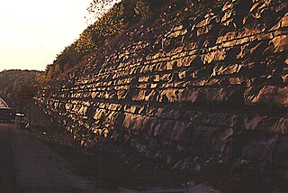
The Big Clifty Sandstone is a geologic formation in Illinois and Kentucky. It is a subunit of the Golconda Formation in Kentucky and is correlative with the Fraileys Shale to which it grades to in southern Illinois. The Big Clifty and Golconda are part of the Chesterian Series of late Mississippian age. The Big Clifty Sandstone was deposited in deltaic to marginal marine environment by the paleo Michigan River which in modern directions flowed south from the Canadian shield, the sediment source, and then westward depositing sediment across Illinois, Kentucky, and Indiana, as the Big Clifty Formation of the Stephensport Group. At Mammoth Cave National Park the Big Clifty overlies the Girkin Formation, the uppermost of three cave forming carbonate formations which the Mammoth-Flint Ridge cave system spans. Below the Girkin Formation are the Ste. Genevieve Limestone, and the St. Louis Limestone respectively. The chemically resistant sediments comprising the Big Clifty, and similar siliciclastics, act as a caprock over the dissolving carbonates. The presence of the Big Clifty is one of several contributory factors that create favorable conditions for the formation, and subsequent preservation, of connected cavernous porosity in the Mammoth-Flint Ridge cave system.

The San Juan Basin is a geologic structural basin located near the Four Corners region of the Southwestern United States. The basin covers 7,500 square miles and resides in northwestern New Mexico, southwestern Colorado, and parts of Utah and Arizona. Specifically, the basin occupies space in the San Juan, Rio Arriba, Sandoval, and McKinley counties in New Mexico, and La Plata and Archuleta counties in Colorado. The basin extends roughly 100 miles (160 km) N-S and 90 miles (140 km) E-W.

The Bend Arch–Fort Worth Basin Province is a major petroleum producing geological system which is primarily located in North Central Texas and southwestern Oklahoma. It is officially designated by the United States Geological Survey (USGS) as Province 045 and classified as the Barnett-Paleozoic Total Petroleum System (TPS).

The Bedford Shale is a shale geologic formation in the states of Ohio, Michigan, Pennsylvania, Kentucky, West Virginia, and Virginia in the United States.
The Exshaw Formation is a stratigraphic unit in the Western Canada Sedimentary Basin. It takes the name from the hamlet of Exshaw, Alberta in the Canadian Rockies, and was first described from outcrops on the banks of Jura Creek north of Exshaw by P.S. Warren in 1937. The formation is of Late Devonian to Early Mississippian age as determined by conodont biostratigraphy, and it straddles the Devonian-Carboniferous boundary.

The New Albany Shale is an organic-rich geologic formation of Devonian and Mississippian age in the Illinois Basin of the United States. It is a major source of hydrocarbons.
The Mississippian Borden Formation is a mapped bedrock unit in Kentucky, Indiana, Illinois, Ohio, West Virginia, and Tennessee. It has many members, which has led some geologists to consider it a group rather than a formation.

The Juncal Formation is a prominent sedimentary geologic unit of Eocene age found in and north of the Santa Ynez Mountain range in southern and central Santa Barbara County and central Ventura County, California. An enormously thick series of sediments deposited over millions of years in environments ranging from nearshore to deep water, it makes up much of the crest of the Santa Ynez range north of Montecito, as well as portions of the San Rafael Mountains in the interior of the county. Its softer shales weather to saddles and swales, supporting a dense growth of brush, and its sandstones form prominent outcrops.

The Fayetteville Shale is a geologic formation of Mississippian age composed of tight shale within the Arkoma Basin of Arkansas and Oklahoma. It is named for the city of Fayetteville, Arkansas, and requires hydraulic fracturing to release the natural gas contained within.

The Surprise Canyon Formation is a geologic formation that consists of clastic and calcareous sedimentary rocks that fill paleovalleys and paleokarst of Late Mississippian (Serpukhovian) age in Grand Canyon. These strata outcrop as isolated, lens-shaped exposures of rocks that fill erosional valleys and locally karsted topography and caves developed in the top of the Redwall Limestone. The Surprise Canyon Formation and associated unconformities represent a significant period of geologic time between the deposition of the Redwall Limestone and the overlying Supai Group.
The Supai Group is a slope-forming section of red bed deposits found in the Colorado Plateau. The group was laid down during the Pennsylvanian to Lower Permian. Cliff-forming interbeds of sandstone are noticeable throughout the group. The Supai Group is especially exposed throughout the Grand Canyon in northwest Arizona, as well as local regions of southwest Utah, such as the Virgin River valley region. It occurs in Arizona at Chino Point, Sycamore Canyon, and famously at Sedona as parts of Oak Creek Canyon. In the Sedona region, it is overlain by the Hermit Formation, and the colorful Schnebly Hill Formation.

The Bluefield Formation is a geologic formation in West Virginia. It preserves fossils dating back to the Mississippian subperiod of the Carboniferous period. Sediments of this age formed along a large marine basin lying in the region of what is now the Appalachian Plateau. The Bluefield Formation is the lowest section of the primarily siliciclastic Mauch Chunk Group, underlying the Stony Gap Sandstone Member of the Hinton Formation and overlying the limestone-rich Greenbrier Group.

The Harrodsburg Limestone is a geologic formation, a member of the Sanders Group of Indiana Limestone, of Mississippian age. It was named for Harrodsburg in southern Monroe County, Indiana by T. C. Hopkins and C. E. Siebenthal. It is made up primarily of calcarenite and calcirudite. It also may include some beds of dolomite and shale.
The Big Clifty Formation is a geologic formation in Indiana. It preserves fossils dating back to the Carboniferous period.
The Pennington Formation is a geologic formation named for Pennington Gap, Virginia. It can be found in outcrops along Pine Mountain and Cumberland Mountain in Kentucky, Virginia, and Tennessee, where it is the uppermost Mississippian-age formation. The name has also been applied to similar Mississippian strata in the Cumberland Escarpment of eastern Kentucky, though the rocks in that area were later renamed to the Paragon Formation.

The Bloyd Formation, or Bloyd Shale, is a geologic formation in Arkansas. It preserves fossils dating back to the Carboniferous period.
The Gray Mesa Formation is a geologic formation in New Mexico. Its fossil assemblage dates the formation to the Moscovian age of the Pennsylvanian.
The Buffalo Wallow Group is a geologic group found in Indiana and Kentucky. It is equivalent to the Upper Pope Group as the two share some formations. However many of the formations in the Upper Pope pinch out and are not present in the Buffalo Wallow. The Buffalo Wallow is defined as the formations between the top of the Glen Dean Limestone up to the disconformity where it meets the Mansfield Limestone.