Vaghena Island

Last updated

Wagina Island
Choiseulandneighbourhood.png
Solomon Islands adm location map.svg
Red pog.svg
Wagina Island
Geography
Location Pacific Ocean
Coordinates 7°26′S157°46′E / 7.433°S 157.767°E / -7.433; 157.767
Archipelago Solomon Islands
Area110 km2 (42 sq mi)
Highest elevation42 m (138 ft)
Administration
Solomon Islands
Demographics
Population1636 (2009)

Wagina Island—or as spelled in colonial times, Vaghena Island—is a small island in the Solomon Islands with 1636 inhabitants, most of whom live along the shores of Kenli Bay, where a small docking station is built for both residents and visitors. The easiest way to reach Wagina is by plane to Kaghau Airport, Choiseul Province, from Honiara (currently twice a week). From Kagau it takes only 45 – 60 minutes by OBM to Wagina.

Solomon Islands Country in Oceania

Solomon Islands is a sovereign state consisting of six major islands and over 900 smaller islands in Oceania lying to the east of Papua New Guinea and northwest of Vanuatu and covering a land area of 28,400 square kilometres (11,000 sq mi). The country's capital, Honiara, is located on the island of Guadalcanal. The country takes its name from the Solomon Islands archipelago, which is a collection of Melanesian islands that also includes the North Solomon Islands, but excludes outlying islands, such as Rennell and Bellona, and the Santa Cruz Islands.

Kaghau Airport is an airport on Kaghau Island in the Solomon Islands. Sometimes it can be called Kagau Airport, or Kagau Island Airport.

Choiseul Province Province in Taro Island, Solomon Islands

The Choiseul Province is one of the nine provinces of Solomon Islands. It lies southeast of Bougainville (part of Papua New Guinea, west of Santa Isabel and north of Vella la Vella, Kolombangra & New Georgia. In the 2009 national census its population is 26,372.

Population

There are three villages in Wagina: Kukutin, Arariki and Nikumaroro. The inhabitants of this island are ethnic I-Kiribati (Micronesians), who were relocated to the British Solomon Islands Protectorate from the islands of Orona (Hull Island) and Nikumaroro (Gardener Island) in the 1950s. This was subsequent to them having been settled on these previously uninhabited islands in the Phoenix Islands from various islands in the Gilberts archipelago in the 1930s. The original resettlement in the 1930s was on alleged grounds of overcrowding, particularly on drought prone islands in the southern Gilberts. The second resettlement was on alleged grounds of the islands in the Phoenix group having harsh living conditions and also prone to drought, although remoteness and costs falling on the colonial administration also played parts. [1] [2] [3]

Orona island

Orona atoll, also known as Hull Island, is one of the Phoenix Islands in the Republic of Kiribati. It measures approximately 8.8 km (5 mi) by 4 km (2 mi), and like Kanton, is a narrow ribbon of land surrounding a sizable lagoon with depths of 15–20 metres (49–66 ft). Numerous passages connect the lagoon to the surrounding ocean, only a couple of which will admit even a small boat. Total land area is 3.9 km2 (2 sq mi), and the maximum elevation is nine metres.

Nikumaroro island

Nikumaroro, or Gardner Island, is part of the Phoenix Islands, Kiribati, in the western Pacific Ocean. It is a remote, elongated, triangular coral atoll with profuse vegetation and a large central marine lagoon. Nikumaroro is about 7.5 km (4.7 mi) long by 2.5 km (1.6 mi) wide. The rim has two narrow entrances, both of which are blocked by a wide reef, which is dry at low tide. The ocean beyond the reef is very deep, and the only anchorage is at the island's west end, across the reef from the ruins of a mid-20th-century British colonial village, but this is safe only with the southeast trade winds. Landing has always been difficult and is most often done south of the anchorage. Although occupied at various times during the past, the island is uninhabited today.

Phoenix Islands archipelago

The Phoenix Islands or Rawaki are a group of eight atolls and two submerged coral reefs, lying in the central Pacific Ocean east of the Gilbert Islands and west of the Line Islands. They are a part of the Republic of Kiribati. During the late 1930s, they became the site of the last attempted colonial expansion of the British Empire through the Phoenix Islands Settlement Scheme. The Phoenix Islands Protected Area, established in 2008, is one of the world's largest protected areas, and home to some 120 species of coral and more than 500 species of fish.

Related Research Articles

Kiribati Island nation in the central Pacific Ocean

Kiribati, officially the Republic of Kiribati, is a sovereign state in Micronesia in the central Pacific Ocean. The permanent population is just over 110,000 (2015), more than half of whom live on Tarawa Atoll. The state comprises 32 atolls and reef islands and one raised coral island, Banaba. They have a total land area of 800 square kilometres (310 sq mi) and are dispersed over 3.5 million square kilometres. Their spread straddles both the equator and the 180th meridian, although the International Date Line goes round Kiribati and swings far to the east, almost reaching the 150°W meridian. This brings the Line Islands into the same day as the Kiribati Islands. Kiribati's easternmost islands, the southern Line Islands, south of Hawaii, have the most advanced time on Earth: UTC+14 hours.

Gilbert Islands chain of sixteen atolls and coral islands in the Pacific Ocean

The Gilbert Islands are a chain of sixteen atolls and coral islands in the Pacific Ocean about halfway between Papua New Guinea and Hawaii. They form the main part of Kiribati.

Gilbert and Ellice Islands

The Gilbert and Ellice Islands were a British protectorate from 1892 and colony from 1916 until 1 January 1976, when the islands were divided into two colonies which became independent nations shortly after. A referendum was held in December 1974 to determine whether the Gilbert Islands and Ellice Islands should each have their own administration. As a consequence of the referendum, the Gilbert and Ellice Islands colony ceased to exist on 1 January 1976 and the separate countries of Kiribati and Tuvalu came into existence.

South Pacific Mandate former country

The South Pacific Mandate was a League of Nations mandate given to the Empire of Japan by the League of Nations following World War I. The South Pacific Mandate consisted of islands in the north Pacific Ocean that had been part of German New Guinea within the German colonial empire until they were occupied by Japan during World War I. Japan governed the islands under the mandate as part of the Japanese colonial empire until World War II, when the United States captured the islands. The islands then became the United Nations-established Trust Territory of the Pacific Islands governed by the United States. The islands are now part of Palau, Northern Mariana Islands, Federated States of Micronesia, and Marshall Islands.

Phoenix Islands Settlement Scheme

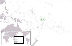
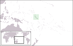
The Phoenix Islands Settlement Scheme was begun in 1938 in the western Pacific ocean and was the last attempt at human colonisation within the British Empire.

Gerald Bernard Gallagher is noted as the first officer-in-charge of the Phoenix Islands Settlement Scheme, the last colonial expansion of the British Empire.

South Malaita Island island

Brief Information on First settlers:

British Western Pacific Territories

The British Western Pacific Territories was the name of a colonial entity, created in 1877, for the administration, under a single representative of the British Crown, styled High Commissioner for the Western Pacific, of a series of Pacific islands in and around Oceania. Except for Fiji and the Solomon Islands, most of these colonial possessions were relatively minor.

British Solomon Islands

British Solomon Islands Protectorate was first declared over the southern Solomons in 1893, when Captain Gibson R.N., of HMS Curacoa, declared the southern islands a British Protectorate. Other islands were subsequently declared to form part of the Protectorate over a period ending in 1900.

Nikunau island

Nikunau is a low coral atoll in the Gilbert Islands and forms a council district of the Republic of Kiribati. It consists of two parts,, joined by an isthmus about 150 metres (490 ft) wide.

Taro Island Place in Choiseul, Solomon Islands

Taro Island is a small island in Solomon Islands with 507 inhabitants, capital of Choiseul Province and is located in Choiseul Bay off the northwest coast.

Nukumanu Islands archipelago

Nukumanu, formerly Tasman Islands, is a medium-sized atoll of Papua New Guinea, located in the Southwestern Pacific Ocean, 4 degrees south of the equator.

British Solomon Islands Protectorate Defence Force

The British Solomon Islands Protectorate Defence Force (BSIPDF) was the British colonial military force of the British Solomon Islands Protectorate (1889–1978). The Solomon Islands has not had military forces since it achieved independence from Britain in 1976. Although the BSIPDF was very small, it played a significant role in the Solomon Islands campaign of World War II.

Ghizo Island island

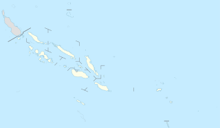
Ghizo Island, home to Gizo, the capital of the Western Province, Solomon Islands. The island is named after an infamous local head-hunter. It is located west of New Georgia and Kolombangara. Ghizo is home to a substantial number of people of I-Kiribati descent. These people were relocated there by the British administration of the British Solomon Islands Protectorate in the 1950s. They had previously spent 20 years on the islands of Orona and Nikumaroro, having been resettled on these previously uninhabited islands in the Phoenix Group from various islands in the Gilberts archipelago in the 1930s. The original resettlement in the 1930s was on alleged grounds of overcrowding, particularly on drought prone islands in the southern Gilberts. The second resettlement was on alleged grounds of the islands in the Phoenix group having harsh living conditions and also prone to drought, although remoteness and costs falling on the colonial administration also played parts. See also Wagina Island.

Arnarvon Islands are a group of islands in Solomon Islands; they are located in Isabel Province and nearby to Wagina Island in Choiseul Province.

Kayeli people

Kayeli people is an ethnic group mainly living on the southern coast of the Kayeli Gulf of Indonesian island Buru, mainly from the Kaiely Gulf. From an ethnographic point of view, Kayeli are close to other indigenous people of Buru, such as Lisela and Buru.

British protectorates were territories over which the British government exercised only limited jurisdiction. Many territories which became British protectorates already had local rulers whom the Crown negotiated with through treaty, acknowledging their status whilst simultaneously offering protection. British protectorates were therefore governed by indirect rule. In most cases, the local ruler, as well as the subjects of the ruler, were not British subjects.

References

  1. Cochrane, G. (1970). The Administration of Wagina Resettlement Scheme. Human Organization, 29(2), 123-132.
  2. Knudson KE. Sydney Island, Titiana, and Kamaleai: Southern Gilbertese in the Phoenix and Solomon Islands. In: Lieber MD, editor, Exiles and migrants in Oceania. Honolulu: University of Hawaii Press; 1977. pp. 195–242.
  3. Maude, H. E. (1952). The colonisation of the Phoenix Islands, Journal of the Polynesian Society, Vol. 61 Nos. 1-2, pp. 62-89.

Coordinates: 6°41′S156°36′E / 6.683°S 156.600°E / -6.683; 156.600

Geographic coordinate system Coordinate system

A geographic coordinate system is a coordinate system that enables every location on Earth to be specified by a set of numbers, letters or symbols. The coordinates are often chosen such that one of the numbers represents a vertical position and two or three of the numbers represent a horizontal position; alternatively, a geographic position may be expressed in a combined three-dimensional Cartesian vector. A common choice of coordinates is latitude, longitude and elevation. To specify a location on a plane requires a map projection.