
The Verde River is a major tributary of the Salt River in the U.S. state of Arizona. It is about 170 miles (270 km) long and carries a mean flow of 602 cubic feet per second (17.0 m3/s) at its mouth. It is one of the largest perennial streams in Arizona.

Navajo Bridge is the name of twin steel spandrel arch bridges that cross the Colorado River in the Grand Canyon National Park in northern Coconino County, Arizona, United States. The newer of the two spans carries vehicular traffic on U.S. Route 89A (US 89A) over Marble Canyon between Bitter Springs and Jacob Lake, allowing travel into a remote Arizona Strip region north of the Colorado River including the North Rim of Grand Canyon National Park.

Tonto National Monument is a National Monument in the Superstition Mountains, in Gila County of central Arizona. The area lies on the northeastern edge of the Sonoran Desert ecoregion, an arid habitat with annual rainfall of about 16 inches (400 mm). The Salt River runs through this area, providing a rare, year-round source of water.

This is intended to be a complete list of the properties and districts on the National Register of Historic Places in Fairfield County, Connecticut, United States. The locations of National Register properties and districts for which the latitude and longitude coordinates are included below may be seen in an online map.
The Wisconsin Bridge and Iron Company (WB&I) was a fabricator and erector of iron and steel bridges and other large structures.

The Sorlie Memorial Bridge, also known as the Red River Bridge, was constructed in 1929 by the Minneapolis Bridge Company to connect the cities of Grand Forks, North Dakota and East Grand Forks, Minnesota. It was placed on the National Register of Historic Places in 1999.

The King Iron Bridge & Manufacturing Company was a late-19th-century bridge building company located in Cleveland, Ohio. It was founded by Zenas King (1818–1892) in 1858 and subsequently managed by his sons, James A. King and Harry W. King and then his grandson, Norman C. King, until the mid-1920s. Many of the bridges built by the company were used during America's expansion west in the late 19th century and early 20th century, and some of these bridges are still standing today.
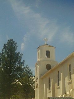
Clarkdale Historic District in Clarkdale, Arizona is a historic district that was listed on the National Register of Historic Places in 1998.

Chevelon Creek Bridge is a historic road bridge located about 12 miles (19 km) southeast of Winslow, in Navajo County, eastern Arizona, United States. It is a steel Warren Pony truss bridge over Chevelon Creek, built on the first permanent road connecting Holbrook, the seat of Navajo County, and Winslow. When built, the road was regionally important in northern Arizona as well as being a segment of an early national highway at the time automobile traffic was growing and national roads were first being formed. The bridge was listed on the National Register of Historic Places in 1983 for being a rare design in Arizona, part of an early transnational roadway, one of the first bridges built by Arizona after statehood in 1912, and being in nearly original condition.

The Mulberry River Bridge, also known as the Silver Bridge and the Wire Ford Bridge, is a historic Pratt through truss bridge northeast of Pleasant Hill, Arkansas, now a neighborhood of the city of Mulberry. The bridge normally carries Wire Road/Center Point Road across the Mulberry River. The bridge has three spans, set on metal caissons filled with concrete, and has a total length of 342 feet (104 m). Each span measures 105 feet (32 m), and has a deck width of 12 feet (3.7 m) and a vertical clearance of 13 feet (4.0 m). In 1927 it was rebuilt when two of the three spans were washed out by the Mulberry River. The bridge is the last known multi-span Pratt through truss bridge in the state.

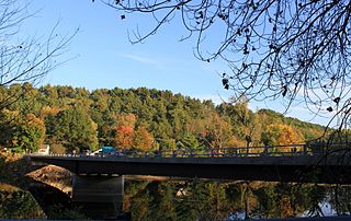
The Perkinsville Bridge over the Verde River was established in 1936 when it was moved from the San Carlos Indian Reservation over the Gila River. The current structure was constructed from spans of the San Carlos Bridge which was built in 1913 and then rebuilt in 1921 after damage due to flooding. It was listed on the National Register of Historic Places in 1989.

The Sawyers Crossing Covered Bridge, also known as the Cresson Bridge, is a wooden covered bridge carrying Sawyers Crossing Road over the Ashuelot River in west Swanzey, New Hampshire. Built in 1859 to replace an older bridge, it continues to serve as a part of Swanzey's transportation network, and is one of the state's few surviving 19th-century covered bridges. It was listed on the National Register of Historic Places in 1978.

The Cameron Suspension Bridge crosses the Little Colorado River at Cameron, Arizona, United States.

Waddell & Harrington was an American engineering company that designed bridges from 1907 to 1915. It was formed in 1907 as a partnership of John Alexander Low Waddell (1854–1938) and John Lyle Harrington (1868–1942) and was based in Kansas City, Missouri, but had offices in Portland, Oregon, and Vancouver, British Columbia. The company designed more than 30 vertical-lift bridges for highways and railroads.

Monarch Engineering Co. was an American firm of Denver, Colorado, active in engineering and construction services. John A. Crook and his brother, Guy A. Crook of Falls City, were founders of the Monarch Engineering company which had its origin and main offices at Falls City, with offices in Kansas City, and Denver. Under the management of these men the Monarch Engineering company had risen to become an important and prosperous concern and a vast amount of bridge construction, city paving, irrigation-dam building, and public building work has been done under their supervision. Within ten years after the firm had been in operation, or since 1908, its activities constantly increased and in 1917 they purchased the Denver Steel and Iron Works in order to facilitate the material supply part of the construction work in which they were engaged.
Architects of the National Park Service are the architects and landscape architects who were employed by the National Park Service (NPS) starting in 1918 to design buildings, structures, roads, trails and other features in the United States National Parks. Many of their works are listed on the National Register of Historic Places, and a number have also been designated as National Historic Landmarks.

The Waterloo Covered Bridge carries Newmarket Road over the Warner River near the Waterloo Falls in Warner, New Hampshire. The Town lattice truss bridge was built in 1859-60, replacing an earlier span at the same location, and is one of New Hampshire's few surviving 19th-century covered bridges. The bridge was listed on the National Register of Historic Places in 1976, and included in the Waterloo Historic District in 2003.
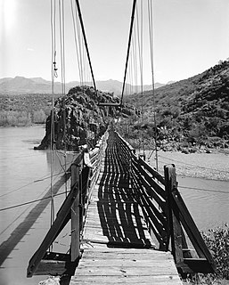
The Verde River Sheep Bridge, also known as the Red Point Sheep Bridge, is a suspension bridge which crosses the Verde River in Arizona. Constructed primarily to allow sheep to be driven between grazing ranges on either side of the river. Building started in 1943 and was completed in 1944. Sheep drives stopped in 1978. The bridge was closed in 1987 and largely demolished in 1988. A replica bridge was constructed in by the U.S. Forest Service in 1989 to allow hikers access to the Mazatzal Wilderness in Tonto National Forest. The original west suspension tower still remains alongside the replica bridge.
The West Milton Bridge is a steel girder bridge carrying Bear Trap Road across the Lamoille River in Milton, Vermont, United States. It was built as a replacement for a 1902 Pennsylvania truss bridge, which was relocated to the site of the Swanton Covered Railroad Bridge, and is listed on the National Register of Historic Places.

The Winooski River Bridge, also known locally as the Checkered House Bridge, is a historic Pennsylvania through truss bridge, carrying U.S. Route 2 (US 2) across the Winooski River in Richmond, Vermont. Built in 1929, it is one of only five Pennsylvania trusses in the state, and was the longest bridge built in the state's bridge-building program that followed massive flooding in 1927. The bridge was listed on the National Register of Historic Places in 1990.


