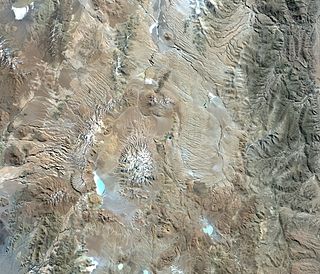
The Vilama caldera was originally estimated to have a size of 40 by 65 kilometres (25mi ×40mi) but the size was later revised to be between 15–18 kilometres (9.3–11.2mi) and 35–40 kilometres (22–25mi) and is almost entirely buried beneath younger volcanoes that have grown along the margin of the caldera; volcanic activity on these volcanoes continued into the Pleistocene. Several lakes also developed on the floor of the caldera, which contains a resurgent dome.
Vilama is the source of the enormous Vilama ignimbrite, which was emplaced during an eruption with a volcanic explosivity index of 8 about 8.4–8.5 million years ago. A large amount of the Vilama ignimbrite is inside the caldera depression, while the part outside of the caldera covers a surface area exceeding 4,000 square kilometres (1,500sqmi). The total volume of the ignimbrite is about 1,200–1,800 cubic kilometres (290–430cumi), possibly as much as 2,100 cubic kilometres (500cumi). Another large ignimbrite, the Sifon ignimbrite, may also have been erupted by Vilama, while the Granada ignimbrite was later attributed to a separate volcano.
Geography and geomorphology
The Vilama caldera lies on the border between Argentina and Bolivia in the Puna-Altiplano, a high plateau in the Central Andes.[2] The volcano straddles the border between Bolivia and Argentina, northeast of Cerro Zapaleri which is the tripoint between Argentina, Bolivia and Chile there.[3] The region is largely uninhabited owing to its harsh climate, however several archeological sites have been found[4] and obsidian from Vilama has been found throughout northwestern Argentina.[5]
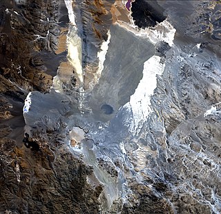
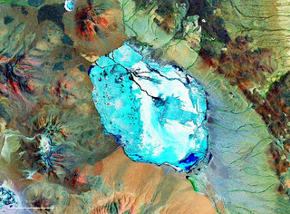
The Vilama caldera is between 15–18 kilometres (9.3–11.2mi) and 35–40 kilometres (22–25mi) wide.[1] Younger volcanic rocks have almost entirely obscured its margins, with the exception of a 250–400-metre (820–1,310ft) high escarpment on the western side of the caldera.[1] The caldera contains a 30-by-10-kilometre (18.6mi ×6.2mi) large[9]resurgent dome surrounded by a 400–800-metre (1,300–2,600ft) deep moat. This moat, which is missing on the eastern side of the caldera, contains several lakes such as Laguna Chojllas[es], Laguna Coruto[es] and Laguna de Vilama[es], the last of which gives the caldera its name. Several younger volcanic centres are found around the caldera and may be located above its margin, such as the Khastor domes and stratovolcano, the Cerro Alcoak[sv] and Cerro Salle[sv] volcanoes,[1] the Cerros Conventos-Niño-Coyamboy chain,[10] Vitichi and Cerro Bayo domes[1] and the 5,678 metres (18,629ft) high[11] Vilama stratovolcano.[12] These edifices are mostly dacitic centres that are considered to be the expression of post-collapse volcanism at the Vilama system.[13]
The caldera was at first considered to be 40 by 65 kilometres (25mi ×40mi) in width with a centre around 22°36′S66°51′W / 22.600°S 66.850°W / -22.600; -66.850,[14] coinciding with the Vilama depression. Vents were localized on the eastern margin beneath the Cerro Caucani, Cerro Solterío, Campanario and Coyaguayma volcanoes,[15] which in turn make up the Abra Granada volcanic complex.[16] One nested caldera associated with the Bonanza ignimbrite was identified as well,[17] the 20-by-40-kilometre (12mi ×25mi) Coruto caldera[18] which is situated southwest of the redefined extent of the Vilama caldera.[19]
Geology
Off the western coast of South America, the oceanic Nazca Platesubducts beneath the South America Plate in the Peru-Chile Trench. Volcanism associated with subduction in the region has been ongoing since the Jurassic.[20] Dehydration of the downgoing slab causes melts to form in the abovelying asthenosphere which drive the activity in the volcanic arc.[8]
East of the main volcanic arc of the Central Volcanic Zone the back-arc region has been volcanically active since the Oligocene, generating volcanic edifices ranging from small monogenetic volcanoes to large calderas with their ignimbrites. The latter form the so-called Altiplano-Puna volcanic complex[14] centered around the Chile-Bolivia-Argentina tripoint,[6] which was mainly active in the Miocene to Pleistocene[14] and is one of the largest such ignimbrite provinces in the world.[21] These centres mainly erupted dacitic magmas.[20] Among the Altiplano-Puna volcanic complex volcanoes are the Cerro Panizos northeast of Vilama and the Cerro Guacha southwest of Vilama;[22] the Vilama, Coruto and Guacha calderas have been designed the "Eduardo Avaroa caldera complex" (Complejo Caldérico Eduardo Avaroa).[23]
The volcanic history of the Altiplano-Puna volcanic complex is poorly known, due to the overlap and burial of older volcanic centres beneath younger ones, difficulties in separating different ignimbrites, the lack of erosion resulting in poor exposure of the units and the challenges of accessing the remote region.[14] Chronological correlations indicate that volcanic activity commenced 10 million years ago and increased 8 million years ago;[24] the onset of volcanic activity was likely triggered by the entry of basaltic magma in the crust after a portion of the lithosphere had broken off.[25] Between 8-4 million years ago large scale eruptions occurred, such as these at Cerro Panizos, Coranzulí, Vilama, Cerro Guacha and La Pacana. Volcanic activity decreased by the Pleistocene, during which activity occurred within the La Pacana caldera and at Cerro Purico,[24] with the most recent eruptions formed the Cerro Chao dome and the Cerro Chascon-Runtu Jarita complex. Ongoing surface deformation at Uturunku is viewed as a sign that volcanic activity in the Altiplano-Puna volcanic complex is still ongoing.[26] Seismic imaging shows the existence of a partially molten magma body in the crust beneath the Altiplano-Puna volcanic complex.[27]
The pre-caldera terrain at Vilama is formed by various sedimentary and volcanic formations, such as the PaleozoicAcoite Formation and the CretaceousSalta Group;[9][12][1]Ordovician sediments are the most important component of the basement while later units only sporadically crop out.[28] Volcanic units of Oligocene-Miocene age predating the formation of the Vilama caldera include the 9.7–9.8 million years old Granada ignimbrite, the 10.25 ± 0.12 million years old Lagunillas ignimbrite, the 9.8 ± 0.7 million years old Ojo de Perico lavas and other volcanic units.[29][30] Later volcanic activity from other volcanoes in the region led to the emplacement of extraneous volcanic rocks in the Vilama caldera, such as the Bonanza, Cienago and Panizos ignimbrites and the Loromayu lavas.[13] In terms of tectonics, during the Cenozoic the region was substantially uplifted, forming a high plateau with an average elevation of about 4 kilometres (2.5mi).[20]
Composition
The Vilama ignimbrite is made out of dacite, which belongs to a potassium-rich calc-alkaline suite.[31] The ignimbrite contains phenocrysts consisting of biotite, hornblende, andesineplagioclase, pyroxenequartz and opaque components.[32] These minerals more generally also form the primary mineral phases of the ignimbrite, while allanite, apatite, iron oxide, titanium oxide and zircon are accessory phases. Probably as a consequence of heterogeneous magma composition, the chemistry and petrography of the ignimbrites varies between separate units and outcrops.[33] It has been inferred that before the eruption the magma was 760–810°C (1,400–1,490°F) hot.[34] A mixing between mantle derived and crustal melts has been suggested to be the source of the magma for both Vilama and other Altiplano-Puna volcanic complex systems.[35]
Climate and vegetation
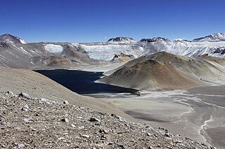
View from the Laguna Vilama to the Vilama stratovolcano, showing a typical landscape
The region has a dry climate with irregular rainfall (300 millimetres per year (12in/year)), temperatures between 3–6°C (37–43°F)[36] and high diurnal temperature variations.[37] Vegetation consists of shrubsteppe,[38] with Festuca, quenoa, tola, Prosopis ferox and yareta being typical members. The volcanically dominated terrain is free of vegetation, with most life occurring close to waterbodies (including the grasses Oxychloe andina and Werneria pygmaea). A number of mammals and birds are found in the region, including flamingos at lakes.[4]
Eruption history
The Vilama caldera is the source of the Vilama ignimbrite, which covers a surface of more than 4,000 square kilometres (1,500sqmi)[39] and was erupted concurrently with the collapse and formation of the caldera.[14] The eruption occurred between 8.4–8.5 million years ago, but with substantial scatter of the radiometric dates which according to Soler et al. 2007 may be due to excess argon contaminating biotites and thus resulting in spurious age data.[40] Based on the characteristics of the ignimbrite, the eruption was likely triggered by the failure of the magma chamber roof and subsequent onset of vigorous fountaining of ignimbrites through vents formed in the magma chamber roof;[41] similar eruption conditions have been inferred for other Altiplano-Puna ignimbrites.[42] The eruption may have taken the form of a Plinian eruption, an unusual occurrence for Altiplano-Puna caldera collapse events.[43]
The ignimbrite is often welded and displays joint features. It is rich in crystals[44] but has little lithic and pumiceous content and few fiamme.[32] The entire ignimbrite contains phenocrysts with sizes reaching about 3–5 millimetres (0.12–0.20in) of length.[33] Detailed descriptions of the ignimbrite were provided by Soler et al. 2007.[45]
Inside the caldera, the Vilama ignimbrite was emplaced as several flow units which are usually 10–20-metre (33–66ft) thick; some units reach thicknesses of 40–50 metres (130–160ft). These units together are at least 400–700 metres (1,300–2,300ft) thick and form a uniform layer of densely welded ignimbrites with poorly preserved pumice and lithic fragments. The ignimbrite deposit inside the caldera shows evidence of flow forms and alteration by vapour interactions. Outside of the caldera, the ignimbrite is formed by two different cooling units with distinct characteristics.[32] The lower cooling unit is massive, poorly welded and contains lithics and pumices; the content of these varies at different sites and there are several different types of pumices. The thickness of the lower cooling unit varies between 7 metres (23ft) to exceeding 110 metres (360ft),[46] and pre-existent topography has controlled the emplacement of the unit;[47] it crops out mainly in valleys.[39] The upper cooling unit is thicker and covers a larger surface than the lower unit, although part of the latter may be buried beneath the upper cooling unit.[46] The upper cooling unit was emplaced on a flat surface as a uniform deposit with thicknesses ranging from 18 metres (59ft) in its southern sector to 60 metres (200ft) north. The upper cooling unit is itself subdivided into a basal and an upper section;[48] the basal section is strongly welded sometimes to the point of being vitrophyric with few fiamme and lithic fragments,[49] whereas the upper section is poorly welded and light brown to pink in colour, with columnar jointing. A transitional area separates the 1–50 metres (3ft 3in– 164ft 1in) thick upper unit with moderate quantities of lithics and fiamme from the lower unit.[50] The two cooling units may have formed under different eruption conditions: High fountains may be the source of the lower cooling unit and lower and less stable fountains that of the upper cooling unit.[39]
The Vilama ignimbrite also includes other ignimbrites that were formerly considered to be separate ignimbrites, such as the Capaderos ignimbrite, Ceja Grande ignimbrite, Tobas Coruto, Tobas Lagunillas 1, Tobas Lagunillas 2, Tobas Lagunillas 3, Tobas Loromayu 1, Tobas Lupi Gera and Toloma ignimbrite.[51] The inclusion of these volcanic products into the Vilama ignimbrite was based on the similarity between their characteristics and those of the actual Vilama ignimbrite,[32] including paleomagnetic and petrologic traits,[52] and together they establish an ignimbrite field elongated towards the south and northwest away from the caldera.[46] The outcrops cover an area of 4,000 square kilometres (1,500sqmi).[53] The total volume of the ignimbrite is difficult to constrain as much of it is not exposed and the shape of the caldera where large parts of the ignimbrite ponded is poorly known, but may range from between 1,200–1,800 cubic kilometres (290–430cumi)[54] to 2,100 cubic kilometres (500cumi),[23] with most of it being contained within the caldera.[55] Based on such sizes, the caldera-forming eruption is considered to be a supereruption with a volcanic explosivity index of 8 and Vilama caldera is thus a supervolcano.[20]
Fracchia et al. 2010 further proposed that the "Pululus ignimbrite" which forms the Cerro Pululos[sv] southeast of Vilama is actually a section of the Vilama ignimbrite, which was later uplifted by a dacitic intrusion.[9] Additionally, it has been proposed that the 1,000 cubic kilometres (240cumi) Sifon ignimbrite, which was erupted 8.33 ± 0.06 million years ago,[56] may originate in the Vilama caldera.[57]
Volcanic activity continued at Vilama after the caldera collapse,[13] driven by a relatively quick recovery of the magmatic system after the formation of the caldera,[41] and resulted in the formation of the resurgent dome.[58] Among the products of this volcanism are the 5–8.1 ± 0.6 million year old northerly Khastor domes and stratovolcano, the 6–8.4 ± 0.6 million year old eastern centres (Cerro Alcoak, Cerro Salle, Bayo dome and the Vilama and Toloma lavas) and the less than 8.4 million years old Mesada Negra lavas on the resurgent dome. The Vitichi domes are of Pliocene age.[13] At Cerro Vilama volcanic activity continued into the Pleistocene,[59] with potassium-argon dating yielding dates of 1.2 ± 0.1 and 900,000 ± 30,000 years ago.[60]Magnetotelluric imaging of the area has identified a low electrical conductivity anomaly beneath the caldera, which may be a solidified magma body.[61]
Originally, the Granada ignimbrite was also considered to be a product of an earlier eruption of the Vilama caldera; later research indicated that it has its own eruptive centre at Abra Granada that is unrelated to Vilama.[28][14] According to this older theory of caldera history, the Granada ignimbrite was the first stage of caldera formation, with the second stage generating the Vilama ignimbrite proper.[62] This theory also envisaged two later stages of activity, the first linked to the Cerro Moradomafic volcanics and the Salle and Ceja Grande ignimbrites, while the fourth produced the Bonanza ignimbrite from the Coruto caldera as well as additional volcanoes including Cerro Zapaleri.[63]
Related Research Articles
Cerro Galán is a caldera in the Catamarca Province of Argentina. It is one of the largest exposed calderas in the world and forms part of the Central Volcanic Zone of the Andes, one of the three volcanic belts found in South America. One of several major caldera systems in the Central Volcanic Zone, the mountain is grouped into the Altiplano–Puna volcanic complex.
The Purico complex is a Pleistocene volcanic complex in Chile close to Bolivia, formed by an ignimbrite, several lava domes and stratovolcanoes and one maar. It is in the Chilean segment of the Central Volcanic Zone, one of the four volcanic belts which make up the Andean Volcanic Belt. The Central Volcanic Zone spans Peru, Bolivia, Chile and Argentina and includes 44 active volcanoes as well as the Altiplano–Puna volcanic complex, a system of large calderas and ignimbrites of which Purico is a member. Licancabur to the north, La Pacana southeast and Guayaques to the east are separate volcanic systems.
La Pacana is a Miocene age caldera in northern Chile's Antofagasta Region. Part of the Central Volcanic Zone of the Andes, it is part of the Altiplano-Puna volcanic complex, a major caldera and silicic ignimbrite volcanic field. This volcanic field is located in remote regions at the Zapaleri tripoint between Chile, Bolivia and Argentina.
Aguas Calientes is a major Miocene caldera in Salta Province, Argentina. It is in the Central Volcanic Zone of the Andes, a zone of volcanism covering southern Peru, Bolivia, northwest Argentina and northern Chile. This zone contains stratovolcanoes and calderas.
Abra Granada is a volcanic complex in the Puna de Atacama in Bolivia. It is located approximately 45 kilometres (28 mi) north of Pirquitas and is composed from a lava dome, lavas and dacitic ignimbrites centering on Cerro Granada and are dated 9.8-7.8 Ma. Deposits erupted 7.9-5.0 mya by this volcano overlie the older Granada ignimbrite. Individual volcanic centres are known as Cerro Caucani, Cerro Granada and Cerro Solterío. The Pirquitas mine is part of the volcanic complex.
The Altiplano–Puna volcanic complex, also known as APVC, is a complex of volcanic systems in the Puna of the Andes. It is located in the Altiplano area, a highland bounded by the Bolivian Cordillera Real in the east and by the main chain of the Andes, the Western Cordillera, in the west. It results from the subduction of the Nazca Plate beneath the South American Plate. Melts caused by subduction have generated the volcanoes of the Andean Volcanic Belt including the APVC. The volcanic province is located between 21° S–24° S latitude. The APVC spans the countries of Argentina, Bolivia and Chile.
Cerro Blanco is a caldera in the Andes of the Catamarca Province in Argentina. Part of the Central Volcanic Zone of the Andes, it is a volcano collapse structure located at an altitude of 4,670 metres (15,320 ft) in a depression. The caldera is associated with a less well-defined caldera to the south and several lava domes.
Cerro Guacha is a Miocene caldera in southwestern Bolivia's Sur Lípez Province. Part of the volcanic system of the Andes, it is considered to be part of the Central Volcanic Zone (CVZ), one of the three volcanic arcs of the Andes, and its associated Altiplano-Puna volcanic complex (APVC). A number of volcanic calderas occur within the latter.
Panizos is a Late Miocene caldera in the Potosí Department of Bolivia and the Jujuy Province of Argentina. It is part of the Altiplano-Puna volcanic complex of the Central Volcanic Zone in the Andes. 50 volcanoes active in recent times are found in the Central Volcanic Zone, and several major caldera complexes are situated in the area. The caldera is located in a difficult-to-access part of the Andes.
Incapillo is a Pleistocene caldera in the La Rioja province of Argentina. It is considered the southernmost volcanic centre in the Central Volcanic Zone (CVZ) of the Andes with Pleistocene activity. Incapillo is one of several ignimbritic or calderic systems that, along with 44 active stratovolcanoes, are part of the CVZ.
Laguna Amarga is a caldera and associated ignimbrite in the Andes of northwestern Argentina.
Cerro Bitiche is a volcanic field in Argentina. It is located east of the Central Volcanic Zone away from the volcanic arc within the Altiplano-Puna volcanic complex (APVC), close to Zapaleri volcano.
Luingo is a caldera in the Andes of Argentina. It is located southeast of the Galan caldera. The caldera is not recognizable from satellite images and is associated with the Pucarilla-Cerro Tipillas volcanic complex.
Negra Muerta is a caldera in Argentina. It is part of the volcanic centres of the Andean Volcanic Belt, which has formed a number of calderas in large ignimbrite producing eruptions. These calderas include Aguas Calientes, Cerro Panizos, Galan, Negra Muerta and La Pacana. Some of these volcanic centres appear to be associated with large fault zones that cross the Puna.
Negro de Chorrillos is a volcano in the Andes.
Pairique volcanic complex is a volcanic complex in the Jujuy Province, Argentina.
Pastos Grandes is the name of a caldera and its crater lake in Bolivia. The caldera is part of the Altiplano-Puna volcanic complex, a large ignimbrite province that is part of the Central Volcanic Zone of the Andes. Pastos Grandes has erupted a number of ignimbrites through its history, some of which exceeded a volume of 1,000 cubic kilometres (240 cu mi). After the ignimbrite phase, the lava domes of the Cerro Chascon-Runtu Jarita complex were erupted close to the caldera and along faults.
Los Frailes is an ignimbrite plateau in Bolivia, between the city of Potosi and the Lake Poopo. It belongs to a group of ignimbrites that exist in the Central Andes and which includes the Altiplano–Puna volcanic complex. The plateau covers a surface of 7,500 square kilometres (2,900 sq mi)–8,500 square kilometres (3,300 sq mi) with about 2,000 cubic kilometres (480 cu mi) of ignimbrite.
Cerro Tuzgle is a dormant stratovolcano in the Susques Department of Jujuy Province in northwestern Argentina. Tuzgle is a prominent volcano of the back arc of the Andes and lies about 280 kilometres (170 mi) east of the main volcanic arc. Part of the Central Volcanic Zone of the Andes, its summit is 5,486 metres (17,999 ft) above sea level and it grew during different stages over a caldera and lava domes. Some major lava flows emanate from the summit crater, and one confirmed and one possible flank collapse unit as well as an ignimbrite sheet are associated with Tuzgle.
Coranzulí is a Miocene caldera in northern Argentina's Jujuy Province. Part of the Argentine Andes' volcanic segment, it is considered a member of the Central Volcanic Zone (CVZ). At the heart of the CVZ lies the Altiplano-Puna volcanic complex, a group of volcanoes of which Coranzulí is a part: the complex has produced large ignimbrite sheets with a combined volume approaching 15,000 cubic kilometres (3,600 cu mi).
Caffe, P.J.; Soler, M.M.; Coira, B.L.; Onoe, A.T.; Cordani, U.G. (June 2008). "The Granada ignimbrite: A compound pyroclastic unit and its relationship with Upper Miocene caldera volcanism in the northern Puna". Journal of South American Earth Sciences. 25 (4): 464–484. Bibcode:2008JSAES..25..464C. doi:10.1016/j.jsames.2007.10.004.
COIRA, B.; CAFFE, P.; RAMÍREZ, A.; CHAYLE, W.; DÍAZ, A.; ROSAS, S.; PÉREZ, A.; PÉREZ, B.; OROZCO, O.; MARTÍNEZ, M. (2004). "Hoja Geológica 2366-I / 2166-III, Mina Pirquitas. Provincia de Jujuy". Boletín 269 (in Spanish). Buenos Aires: Instituto de Geología y Recursos Minerales, Servicio Geológico Minero Argentino. – via ResearchGate.
Francis, P. W.; Hawkesworth, C. J. (1 September 1994). "Late Cenozoic rates of magmatic activity in the Central Andes and their relationships to continental crust formation and thickening". Journal of the Geological Society. 151 (5): 845–854. Bibcode:1994JGSoc.151..845F. doi:10.1144/gsjgs.151.5.0845. S2CID129179678.
Kay, Suzanne Mahlburg; Coira, Beatriz L.; Caffe, Pablo J.; Chen, Chang-Hwa (December 2010). "Regional chemical diversity, crustal and mantle sources and evolution of central Andean Puna plateau ignimbrites". Journal of Volcanology and Geothermal Research. 198 (1–2): 81–111. Bibcode:2010JVGR..198...81K. doi:10.1016/j.jvolgeores.2010.08.013.
Salisbury, M. J.; Jicha, B. R.; de Silva, S. L.; Singer, B. S.; Jimenez, N. C.; Ort, M. H. (1 May 2011). "40Ar/39Ar chronostratigraphy of Altiplano-Puna volcanic complex ignimbrites reveals the development of a major magmatic province". Geological Society of America Bulletin. 123 (5–6): 821–840. Bibcode:2011GSAB..123..821S. doi:10.1130/B30280.1.
De Silva, Shanaka; Zandt, George; Trumbull, Robert; Viramonte, José G.; Salas, Guido; Jiménez, Néstor (2006). "Large ignimbrite eruptions and volcano-tectonic depressions in the Central Andes: a thermomechanical perspective". Geological Society, London, Special Publications. 269 (1): 47–63. Bibcode:2006GSLSP.269...47D. doi:10.1144/GSL.SP.2006.269.01.04. S2CID129924955.
Soler, M.M.; Caffe, P.J; Coira, B.L.; Onoe, A.T.; Kay, S. Mahlburg (July 2007). "Geology of the Vilama caldera: A new interpretation of a large-scale explosive event in the Central Andean plateau during the Upper Miocene". Journal of Volcanology and Geothermal Research. 164 (1–2): 27–53. Bibcode:2007JVGR..164...27S. doi:10.1016/j.jvolgeores.2007.04.002.
Coira, Beatriz; Mahlburg Kay, Suzanne; Caffe, Pablo J. (2008). "Magmatismo Neógeno Tardío de la Puna norte". Geología y recursos naturales de la provincia de Jujuy. Asociación Geológica Argentina. pp.313–321. ISBN978-987-22403-2-5.
This page is based on this Wikipedia article Text is available under the CC BY-SA 4.0 license; additional terms may apply. Images, videos and audio are available under their respective licenses.