
San Cristóbal is a city in the southern region of Dominican Republic. It is the municipal (municipio) capital of the San Cristóbal province. The municipality is located in a valley at the foothills of the mountains belonging to the Cordillera Central, between the Nigua and Nizao rivers. Within this municipality there is one municipal district : Hato Damas.

Baoruco, alternatively spelt Bahoruco, is a province of the Dominican Republic located in the southwest of the country, part of the Enriquillo Region, along with the provinces of Barahona, Independencia and Pedernales. Before 1952 it included what is now Independencia Province.

Duarte is a northeastern province which comprises one of the 32 provinces of the Dominican Republic. It is divided into 7 municipalities and its capital city is San Francisco de Macorís. It is bordered by the provinces of María Trinidad Sánchez and Samaná to the east, Monte Plata and Sánchez Ramírez to the south, La Vega and Hermanas Mirabal to the west and Espaillat to the north. It is named after Juan Pablo Duarte, the founder of the Dominican Republic.

El Seibo, alternatively spelt El Seybo, is a province of the Dominican Republic. Before 1992 it included what is now Hato Mayor province.

Espaillat is one of the 32 provinces of the Dominican Republic. It is divided into 5 municipalities and its capital city is Moca. Located in north-central Dominican Republic (Cibao), it is bordered by the provinces of La Vega to the south, Santiago and Puerto Plata to the west, and María Trinidad Sánchez to the north-east. The province has a coastline to the north with the Atlantic Ocean. It is named for Ulises Francisco Espaillat (1823–1878), the 19th-century author who was briefly President of the Republic in 1876.

Monte Cristi is a province in the northwest of the Dominican Republic. The capital city is San Fernando de Monte Cristi. The spelling Montecristi is also seen. The Montecristi province is located in the Cibao frontier region, on the north coast of the country and borders the nation of Haiti. The land area of the Montecristi province is 1,924.35 km2. It is divided into six municipalities and four municipal districts.

Puerto Plata ; is a province in northern Dominican Republic. It is divided into 9 municipalities, 12 municipal districts and its capital is the resort city of the same name. Neighboring provinces clockwise: Monte Cristi to the southwest, Valverde and Santiago to the south and Espailat to the east, along with the Septentrional mountain range to the north, and has a coastline with the Atlantic Ocean. The area has become an increasingly popular tourist attraction since the late 1990s mainly due to its fine beaches.

San Pedro de Macorís is a province of the Dominican Republic, also the name of its capital city. The city is fairly active due to its proximity to the national capital of Santo Domingo and also its role in the sugar industry. The province is informally known as San Pedro, SPM or Serie 23 for the first two numbers of their Dominican identification or Cedula.
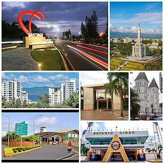
Santiago is a province which currently comprises one of the 32 provinces of the Dominican Republic. It is divided into 10 municipalities and its capital city is Santiago de los Caballeros. Located in north-central Dominican Republic, in the Cibao region, it is bordered by the provinces of Valverde to the north-west, Puerto Plata to the north, Espaillat and La Vega to the east, San Juan to the south and Santiago Rodríguez to the west.

Valverde is a province of the Dominican Republic. It was split from Santiago Province in 1959. It is in the northwestern part of the country. Its capital city is Santa Cruz de Mao.
Sabana Grande de Palenque is a municipality (municipio) of the San Cristóbal province in the Dominican Republic.

Azua de Compostela, also known simply as Azua, is a city, municipality (municipio) and capital of Azua Province in the southern region of Dominican Republic. Founded in 1504, Azua is one of the oldest European settlements in the Americas. The town is located 100 kilometres west of the national capital, Santo Domingo.

Monte Plata is a town and municipality (municipio) and the capital of the Monte Plata province in the Dominican Republic. It includes the municipal districts of Boyá, Chirino, and Don Juan.
Esperanza is a municipality (municipio) of the Valverde province in the Dominican Republic. Within the municipality there are four municipal districts : Boca de Mao, Jicomé, Maizal and Paradero.
Villa Altagracia is a municipality (municipio) of the San Cristóbal province in the Dominican Republic. Within the municipality there are three municipal districts : La Cuchilla, Medina and San José del Puerto.

San José de las Matas, also known as Sajoma, is an important municipality (municipio) of the Santiago province in the Dominican Republic. The mayor of Sajoma is Alfredo Reyes. There have been many positive changes in the last four years including the addition of a 911 system. Within the municipality there are three municipal districts : El Rubio, La Cuesta and Las Placetas.
Navarrete is a municipality in northwestern Dominican Republic, created in 1961. It lies approximately 25 kilometres (16 mi) from Santiago de los Caballeros, Dominican Republic's second largest city. The administrative centre is in the town of Villa Bisonó.

Yamasá is a municipality (municipio) of the Monte Plata province in the Dominican Republic. It includes the municipal district of Los Botados. Yamasa is north of the capital city of Santo Domingo. The Rio Ozama, one of Dominican Republic's longest rivers, passes through Yamasa.
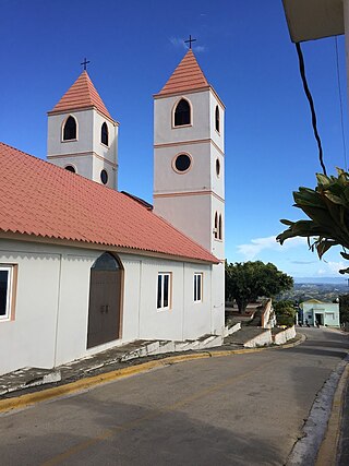
Jánico is a town and municipality (municipio) of the Santiago province in the Dominican Republic. Within the municipality there are two municipal districts : El Caimito and Juncalito.

Moca is the capital of Espaillat province in the Cibao region of the Dominican Republic, and is the tenth-largest city of the country with a population of 173,442 inhabitants. Moca is located 11 miles/18 kilometers east from the country’s second-largest city, Santiago. It is divided into eight municipal districts: San Víctor, Las Lagunas, José Contreras, Juan López, El Higuerito, La Ortega, Monte de la Jagua and Canca La Reina.

