
Azua is a province which is collectively one of the thirty-two provinces of the Dominican Republic. It is divided into 10 municipalities and its capital city is Azua de Compostela. It is bordered by the provinces of La Vega to the north-east, San José de Ocoa and Peravia to the east, Barahona and Baoruco to the west and San Juan to the north-west. To the south, Azua has a significant coastline of the Caribbean Sea. Azua is known for its diverse geography and climate, with the southern part of the province having an arid climate that is not the typical tropical-like that is found in other parts of the Caribbean.

Dajabón is a northwestern province which currently comprises one of the 32 provinces of the Dominican Republic. It is divided into 5 municipalities and its capital city with the same name. It is bordered by the provinces of Monte Cristi to the north, Santiago Rodríguez to the south, Elías Piña to the south and the Nord-Est department of Haiti to the west.

La Vega is one of the 32 provinces of the Dominican Republic. It is located in the Cibao Valley, the north-central region of the country, and is divided into 4 municipalities with its capital city being the namesake of La Vega. The province borders Espaillat and Hermanas Mirabal to the north, Duarte to the east, Monseñor Nouel to the south and Santiago to the west.
Monseñor Nouel is a province in the central region of the Dominican Republic. It was split from La Vega province in 1982.

Monte Cristi is a province in the northwest of the Dominican Republic. The capital city is San Fernando de Monte Cristi. The spelling Montecristi is also seen. The Montecristi province is located in the Cibao frontier region, on the north coast of the country and borders the nation of Haiti. The land area of the Montecristi province is 1,924.35 km2. It is divided into six municipalities and four municipal districts.

Monte Plata is an eastern province of the Dominican Republic, and also the name of its capital city. It was split from San Cristóbal in 1992.

Puerto Plata ; is a province in northern Dominican Republic. It is divided into 9 municipalities, 12 municipal districts and its capital is the resort city of the same name. Neighboring provinces clockwise: Monte Cristi to the southwest, Valverde and Santiago to the south and Espailat to the east, along with the Septentrional mountain range to the north, and has a coastline with the Atlantic Ocean. The area has become an increasingly popular tourist attraction since the late 1990s mainly due to its fine beaches.

Samaná is a province of the Dominican Republic in the Samaná Peninsula located in the eastern region. Its capital is Santa Bárbara de Samaná, usually known as Samaná.

Santiago is a province which currently comprises one of the 32 provinces of the Dominican Republic. It is divided into 10 municipalities and its capital city is Santiago de los Caballeros. Located in north-central Dominican Republic, in the Cibao region, it is bordered by the provinces of Valverde to the north-west, Puerto Plata to the north, Espaillat and La Vega to the east, San Juan to the south and Santiago Rodríguez to the west.

Santiago Rodríguez is a province in the northwest region of the Dominican Republic. It was split from Monte Cristi in 1948. The Santiago Rodríguez province has the Monte Cristi and Valverde provinces to the north, the Santiago province to the east, the San Juan and Elías Piña provinces to the south and the Dajabón province to the west.

Valverde is a province of the Dominican Republic. It was split from Santiago Province in 1959. It is in the northwestern part of the country. Its capital city is Santa Cruz de Mao.

Samaná, in full Santa Bárbara de Samaná, is a town and municipality in northeastern Dominican Republic and the capital of Samaná Province. It is on the northern coast of Samaná Bay. The town is an important tourism destination and the main center for whale-watching tours in the Caribbean region.

Azua de Compostela, also known simply as Azua, is a city, municipality (municipio) and capital of Azua Province in the southern region of Dominican Republic. Founded in 1504, Azua is one of the oldest European settlements in the Americas. The town is located 100 kilometres west of the national capital, Santo Domingo.

San José de las Matas, also known as Sajoma, is an important municipality (municipio) of the Santiago province in the Dominican Republic. The mayor of Sajoma is Alfredo Reyes. There have been many positive changes in the last four years including the addition of a 911 system. Within the municipality there are three municipal districts : El Rubio, La Cuesta and Las Placetas.
Licey al Medio is a municipality (municipio) of the Santiago province in the Dominican Republic. Within the municipality there is one municipal district : Las Palomas. The Cibao International Airport is located here.
Navarrete is a municipality in northwestern Dominican Republic, created in 1961. It lies approximately 25 kilometres (16 mi) from Santiago de los Caballeros, Dominican Republic's second largest city. The administrative centre is in the town of Villa Bisonó.
Hondo Valle is a town in the Elías Piña province of the Dominican Republic characterized by its beautiful mountains and cold climate.

Altamira is a town in the Puerto Plata Province of the Dominican Republic.
San Juan is a province of the Dominican Republic. Before 1961 it was known as Benefactor. San Juan is the Republic's largest province, bearing a size of 3,569 square kilometers, and it is landlocked.
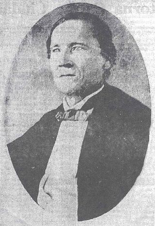
Fernando Valerio Gil was an agriculturalist and soldier from the Dominican Republic. He is considered a hero of the battles of Santiago —together with José María Imbert—, and Sabana Larga —together with Juan Luis Franco Bidó—. He was commander in chief of the northern border.


