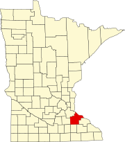
Goodhue County is a county in the U.S. state of Minnesota. As of the 2020 census, the population was 47,582. Its county seat is Red Wing. Nearly all of Prairie Island Indian Community is within the county.
Beatty Township is a township in Saint Louis County, Minnesota, United States. Beatty Township bears the name of a family of pioneer settlers. The population was 372 at the 2010 census.
White Township is an urban township in Saint Louis County, Minnesota, United States. The population was 3,229 at the 2010 census.

Split Rock Creek State Park is a state park of Minnesota, USA, located in Ihlen, or just south of Pipestone.
Makinen is an unincorporated community in St. Louis County, Minnesota, United States.
Bassett is an unincorporated community in Bassett Township, Saint Louis County, Minnesota, United States located within the Superior National Forest.

Maple Springs is an unincorporated community in Pepin Township, Wabasha County, Minnesota, United States, along the Mississippi River and Lake Pepin. The Mississippi River and King Creek meet at Maple Springs.
Ryan is an unincorporated community in Belle Creek Township, Goodhue County, Minnesota, United States.
Belvidere Mills is an unincorporated community in Belvidere Township, Goodhue County, Minnesota, United States.
White Rock is an unincorporated community in Goodhue County, Minnesota, United States.
Cloverton is an unincorporated community in New Dosey Township, Pine County, Minnesota, United States.
Toimi is an unincorporated community in Lake County, Minnesota, United States. The community is located 31 miles north of the city of Two Harbors at the intersection of Lake County Highway 15 / Forest Highway 11 (co-signed) and County Road 151, Etelainen Road.
Pomroy is an unincorporated community in Pomroy Township, Itasca County, Minnesota, United States.
Ellson is an unincorporated community in Bremen Township, Pine County, Minnesota, United States.
Greeley is an unincorporated community in Royalton Township, Pine County, Minnesota, United States.
Woodland is an unincorporated community in Ford Township, Kanabec County, Minnesota, United States.
Hay Creek is an unincorporated community in Hay Creek Township, Goodhue County, Minnesota, United States.
Claybank is an unincorporated community in Goodhue Township, Goodhue County, Minnesota, United States.
Bear Valley is an unincorporated community in Chester Township, Wabasha County, Minnesota, United States.
Wacouta I (Shooter) was a leader of the Red Wing band of Mdewakanton Dakota during the time of United States expansion into his people's homeland.


