
Oxley Highway is a rural highway in New South Wales, Australia, linking Nevertire, Gilgandra, Coonabarabran, Tamworth, and Walcha to Port Macquarie, on the coast of the Tasman Sea. It was named to commemorate John Oxley, the first European to explore much of inland New South Wales in 1818.

Walcha is a town at the south-eastern edge of the Northern Tablelands, New South Wales, Australia.

Thunderbolts Way is a 305-kilometre (190 mi) country road located in the Northern Tablelands region of New South Wales, Australia, linking Inverell via Bundarra, Uralla and Walcha to Gloucester The road is partially sealed and passes through thickly forested mountain areas with many nearby national parks and nature reserves.

The Northern Tablelands, also known as the New England Tableland, is a plateau and a region of the Great Dividing Range in northern New South Wales, Australia. It includes the New England Range, the narrow highlands area of the New England region, stretching from the Moonbi Range in the south to the Queensland border in the north. The region corresponds generally to the Bureau of Meteorology forecast area for the Northern Tablelands which in this case includes Inverell although it is significantly lower in elevation.

Walcha Shire is a local government area located in the New England region of New South Wales, Australia. The Shire is situated adjacent to the junction of the Oxley Highway and Thunderbolts Way and is 20 kilometres (12 mi) east of the Main North railway line passing through Walcha Road. The shire was formed on 1 June 1955 through the amalgamation of Apsley Shire and the Municipality of Walcha.

Walcha Road is a rural village with a population of about 20, located 19 kilometres (12 mi) west of Walcha in the Northern Tablelands of New South Wales, Australia.
Uralla-Walcha was an electoral district of the Legislative Assembly in the Australian state of New South Wales, including the towns of Uralla and Walcha. It was originally created in 1894, when multi-member districts were abolished, and the three member district of New England was largely divided between Uralla-Walcha, Armidale and Bingara. The district was abolished in 1904 as a result of the 1903 New South Wales referendum, which reduced the number of members of the Legislative Assembly from 125 to 90, and was divided between Armidale and Bingara.
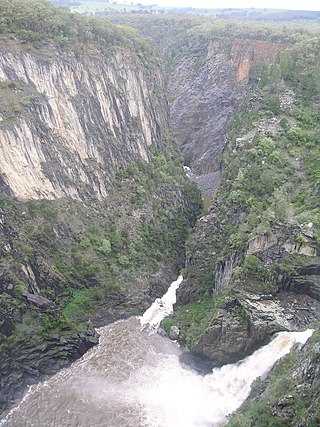
The Apsley Falls are two waterfalls on the Apsley River in the Northern Tablelands region of New South Wales, Australia. The falls are located about 20 kilometres (12 mi) east of Walcha, and 1 kilometre off the Oxley Highway in a deep gorge, that is part of the Oxley Wild Rivers National Park. They are the first falls in a succession of dramatic drops in an area that has some of the most remarkable scenery in Eastern Australia. The first drop of the falls is about 65 metres (213 ft) in depth, and the second, which is about 800 metres (2,625 ft) further on, plummets 58 metres (190 ft) to the bottom of the gorge.

Woolbrook is a village in the New England region of New South Wales, Australia. The nearest town, Walcha is 29 km to the east of Woolbrook. At the 2011 census, Woolbrook had a population of 248.

Apsley River, a perennial stream of the Macleay River catchment, is located in the Northern Tablelands district of New South Wales, Australia.
Scone Memorial Airport, is a public airport in the Upper Hunter Valley, 4 km (2.5 mi) northwest of Scone, New South Wales, Australia. It was built to provide a public aerodrome replacing Nandowra aerodrome on located on "Nandowra", approx. 9 km south of Scone.

Cobrabald River, a mostly perennial river that is part of the Namoi catchment within the Murray–Darling basin, is located in the Northern Tablelands district of New South Wales, Australia.

Nowendoc River, a perennial river of the Manning River catchment, is located in the Northern Tablelands and Mid North Coast districts of New South Wales, Australia.
Walcrow River, a watercourse of the Manning River catchment, is located in the Northern Tablelands and Mid North Coast districts of New South Wales, Australia.

Walcha Road railway station is a heritage-listed railway station located on the Main Northern line in Walcha Road, Walcha Shire, New South Wales, Australia. The railway station serves the village of Walcha Road and town of Walcha, opening on 2 August 1882 when the line was extended from Kootingal to Uralla. It is also known as Walcha Road Railway Station and yard group. The property was added to the New South Wales State Heritage Register on 2 April 1999.
The Walcha News, originally published as The Walcha News and Southern New England Advocate, is an English language newspaper published in Walcha, New South Wales.

St Andrew's Anglican Church is a heritage-listed former Anglican church located at South Street, Walcha in the Walcha Shire, New South Wales, Australia. The site was added to the New South Wales State Heritage Register on 2 April 1999.
Elizabeth Lorraine Holstein was an Australian tennis player. She won the girls' doubles title at the 1952, 1954 and 1958 Australian Championship.
Uralla-Walcha, an electoral district of the Legislative Assembly in the Australian state of New South Wales, was created in 1894 and abolished in 1904.
