
Eldora, previously known as "Eldorado" then "El-Dora", then Eldora or Camp Eldorado, and still called Happy Valley, is an unincorporated community and a census-designated place (CDP) located in and governed by Boulder County, Colorado, United States. The CDP is a part of the Boulder, CO Metropolitan Statistical Area. The population of the Eldora CDP was 140 at the United States Census 2020. The Nederland post office serves the area.
Gold Hill is an unincorporated community and a census-designated place (CDP) located in and governed by Boulder County, Colorado, United States. The CDP is a part of the Boulder, CO Metropolitan Statistical Area. The population of the Gold Hill CDP was 218 at the United States Census 2020. The Boulder post office serves the area.

Lake City is a statutory town that is the county seat, the most populous community, and the only incorporated municipality in Hinsdale County, Colorado, United States. The population was 432 at the 2020 census. It is located in the San Juan Mountains in a valley formed by the convergence of Henson Creek and the headwaters of the Lake Fork of the Gunnison River about seven miles (11 km) east of Uncompahgre Peak, a Colorado fourteener. Lake City is named after nearby Lake San Cristobal. This area lies at the southern end of the Colorado Mineral Belt and when rich mineral deposits were discovered the native population was pushed from their tribal lands and the town of Lake City was incorporated in 1873.

There are more than 1,500 properties and historic districts in the U.S. State of Colorado listed on the National Register of Historic Places. They are distributed over 63 of Colorado's 64 counties; only the City and County of Broomfield currently has none.
Fort Vasquez is a former fur trading post 35 miles (56 km) northeast of Denver, Colorado, United States, founded by Louis Vasquez and Andrew Sublette in 1835. Restored by the Works Progress Administration in the 1930s, it now lies in a rather incongruous position as U.S. Route 85 splits to run either side of the building. History Colorado took possession of the property in 1958 and runs it as a museum to display exhibits of the fur-trade era.
Hannah Connell Barker (1844–1918) was an early resident of Boulder, Colorado. Barker was a teacher, civic leader, businesswoman and land developer in an era when industrious women were not commonly recognized for their contributions. Among other things, Barker served as a teacher; as director of the Boulder Bank; and was instrumental in platting and developing significant parts of the City of Boulder. She also owned the land that was used for the construction of Barker Meadow Reservoir, Boulder's primary source of water.
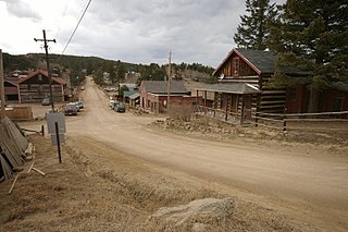
Eldora Historic District is a 30 acres (12 ha) historic district in Eldora, Colorado. Other names of the district and/or other historic names of places in the district are Happy Valley, Eldorado Camp, and 5BL758. It was listed on the National Register of Historic Places in 1989. The listing included 55 contributing buildings and 12 non-contributing ones.

St. Elmo is a ghost town in Chaffee County, Colorado, United States. Founded in 1880, St. Elmo lies in the heart of the Sawatch Range, 20 miles (32 km) southwest of Buena Vista and sits at an elevation of 9,961 feet (3,036 m). Nearly 2,000 people settled in this town when mining for gold and silver started. The mining industry started to decline in the early 1920s, and in 1922 the railroad discontinued service. The community is listed on the National Register of Historic Places as the St. Elmo Historic District. It is one of Colorado's best preserved ghost towns.

The Switzerland Trail is the site of a historic 3 ft narrow gauge railroad line that was operated at different times by the Greeley, Salt Lake and Pacific Railway, the Colorado and Northwestern Railroad, and the Denver, Boulder, and Western Railroad around the turn of the 20th century in the Colorado front range mining area near Nederland, Gold Hill, and Ward. The west end of the trail is listed on the National Register of Historic Places as the "Denver, Boulder and Western Railway Historic District".

Franklin is an unincorporated community in Crawford County, Kansas, United States. As of the 2020 census, the population of the community and nearby areas was 473. Franklin is located along U.S. Route 69, 1 mile (1.6 km) south of Arma, or 5.9 miles (9.5 km) north of Frontenac.

Beth Salem Presbyterian Church is a historic African-American church in Athens, Tennessee.

The Woodvale Historic District is a national historic district that encompasses multiple historic properties that are located in Broad Top Township, Bedford County, Wells Township, Fulton County, and Wood Township, Huntingdon County, Pennsylvania.
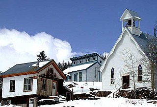
Ward Congregational Church, at 41 Modoc in Ward, Colorado, was built in 1894-95 and is listed on the National Register of Historic Places.
Boulder Crescent Place Historic District is a historic area in Colorado Springs, Colorado along West Boulder and Cascade Avenue near the intersection of the two streets. It is a National Register of Historic Places listing and is on the Colorado State Register of Historic Properties.

The Drennan School, also known as the Drennan Community Building, is a historic building in Ellicott, near Colorado Springs, Colorado. The building was first owned by the Widefield School District in El Paso County. It is on the National Register of Historic Places.

The Little Church in the Pines is a c. 1902-1908 building in the former mining town of Salina in Boulder County, Colorado. The church held regular Sunday School classes for children, and services whenever a traveling minister came to town. As the mining boom came to an end and the town's population shrunk, the building fell into disuse, and briefly served as a mine office before being abandoned. In 1948 it was purchased by a neighborhood group and has been used ever since for nondenominational worship and community events. The Little Church in the Pines was placed on the National Register of Historic Places in 1989.

The Salina School, also known as the Salina Schoolhouse, is a one-room schoolbuilding in the former mining town of Salina in Boulder County, Colorado, built around 1875 or 1876. It was listed on the National Register of Historic Places in 1989.

The Wall Street Assay Office is a historic commercial building related to precious metal mining in the western outskirts of Boulder, Colorado in an area known as Wall Street. Once a thriving mining town in Boulder County's foothills area, Wall Street is now home to a few dozen residential properties scattered among the remnants of the Storm King mine. The Wall Street Assay Office sits on Four Mile Canyon Dr, now preserved as the James F. Bailey Assay Office Museum.

Columbine or Columbine Gold Camp is a former gold mining community in Routt County, Colorado, United States. Now it is an unincorporated community, historic district, and a rental cabin resort. It dates from around 1895. It was listed as a historic district on the National Register of Historic Places in 2007.

The Robinson House in Louisville, Colorado, at 301 Spruce, also known as the Cedarberg House, was built in 1904. It was listed on the National Register of Historic Places in 1986.

