
John Calvin Stevens was an American architect who worked in the Shingle Style, in which he was a major innovator, and the Colonial Revival style. He designed more than 1,000 buildings in the state of Maine.

The Canterbury Center Historic District is a historic district in Canterbury, Connecticut. The district is centered on the town green, located at the junction of Route 169 and Route 14. It has been the town center since 1705, and includes a fine assortment of 18th and early 19th-century architecture. It was listed on the National Register of Historic Places (NRHP) in 1998.

The South Britain Historic District in Southbury, Connecticut, United States, is a historic district that was listed on the National Register of Historic Places in 1987. It represents the central portion of South Britain, an unincorporated village. The district is bordered by the Pomperaug River on the west. Water-powered mills, supplied by water from a South Britain Water Power Company reservoir, were the impetus for early development.
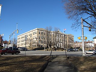
The Main Street Historic District in Haverhill, Massachusetts represents the civic core of Haverhill and a gateway to the city's Highlands neighborhood and lakes district. Overlooking a mid-20th century urban renewal clearance area northeast of the main business and industrial district of the city, it was listed on the National Register of Historic Places in 2003.

The Graniteville Historic District is a mainly residential historic district in Waterford, Connecticut. It is ranged along Rope Ferry Road, near granite quarries that were once a major industry in the town. Most of the 31 historical buildings in the district are plain residences occupied by quarry workers; also included are the c. 1878 Graniteville School at 239 Rope Ferry Road, and the house of John Palmer, one of the proprietors of the quarries, at 218 Rope Ferry Road. His house, a c. 1860 Italianate updating of an older house, is the most elaborate house in the district. The district was listed on the National Register of Historic Places in 2003.
The North Stonington Village Historic District is a 105-acre (42 ha) historic district encompassing the historic center of the main village of North Stonington, Connecticut. The district includes a well-preserved small industrial village, which flourished in the years before the American Civil War, and declined afterward. The district was listed on the National Register of Historic Places in 1983.

The Western Promenade Historic District encompasses a large late 19th to early 20th century neighborhood in the West End of Portland, Maine. This area of architecturally distinctive homes was home to three of the city's most prominent architects: Francis H. Fassett, John Calvin Stevens, and Frederick A. Tompson, and was Portland's most fashionable neighborhood in the late 19th century. The district was listed on the National Register of Historic Places in 1984.
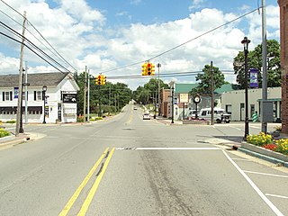
The Metamora Crossroads Historic District is a historic district centered at the intersection of Oak and High Street in the small village of Metamora in Metamora Township in Lapeer County, Michigan. It was designated as a Michigan State Historic Site and also added to the National Register of Historic Places on July 19, 1984.

Waterford Borough Historic District is a national historic district located at Waterford, Erie County, Pennsylvania. It includes 41 contributing buildings in the central business district and surrounding residential areas of Waterford. The district includes commercial and residential buildings built between 1820 and 1939. They are in a variety of popular architectural styles including Greek Revival, Federal, and Italianate. The district includes the town square. Notable buildings include the St. Peter's Episcopal Church (1832), Presbyterian Church, Amos Judson House, and Judson's Store (1820). The district includes the separately listed Eagle Hotel (1826).

The Alfred Historic District is an historic district encompassing the historic village center of Alfred, Maine. The roughly Y-shaped district radiates from the junction of Oak Street with Kennebunk, Waterboro, and Saco Roads, and is characterized by high-quality 19th-century wood frame buildings. The district was added to the National Register of Historic Places in 1983.
The Harraseeket Historic District encompasses some of the oldest maritime village areas of the town of Freeport, Maine. It includes properties along both banks of the tidal Harraseeket River, from the Mast Landing area in the north to Wolf Neck and the villages of Porter Landing and South Freeport on the west bank of the river. The district was listed on the National Register of Historic Places in 1974.

The Broad Street Historic District encompasses a significant portion of the historic center of Bethel, Maine. Broad Street dates to the early days of Bethel's settlement in the early 19th century, and its town common was a gift from the first settler of the area. As originally listed on the National Register of Historic Places in 1977, the district included the common and a section of Broad Street between Main Street and Paradise Hill Road. This was expanded in 1990 along Church Street to encompass historic homes and a portion of the Gould Academy campus.

The Main Street Historic District of Fryeburg, Maine, encompasses the growth of the town's principal village between about 1800 and 1935. It extends along Main Street, from Woodland Street in the north to Portland Street (SR 5 and Maine State Route 113) in the south, and includes forty primary buildings on 55 acres (22 ha). The district was listed on the National Register of Historic Places in 1991.
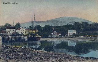
The Blue Hill Historic District encompasses the historic village center of the town of Blue Hill, Maine. The village, established in 1762, is a well-preserved collection of buildings, many of them built before 1840. Most of the older buildings are residential in character; the modest collection of commercial and civic buildings were mostly built between 1880 and 1940. The district was listed on the National Register of Historic Places in 1980.

The Skowhegan Historic District encompasses the historic late 19th-century central business district of Skowhegan, Maine. The district is located on Madison Avenue and Water Streets on the north bank of the Kennebec River, and includes 37 historic buildings built between 1850 and 1910, including Skowhegan Town Hall, designed by John Calvin Stevens and built in 1909. The district was listed on the National Register of Historic Places in 1982.
The Calais Residential Historic District encompasses the town's best collection of well-preserved 19th-century residences in Calais, Maine. Located on Calais Street and Main Street, the district includes twenty properties developed between the early 19th century and 1900. It was listed on the National Register of Historic Places in 1994.

The Limington Historic District encompasses the historic village center of the rural community of Limington, Maine. Centered at the junction of Maine State Routes 11 and 117, the district includes 24 buildings erected between the late 18th and mid-19th centuries. The district was listed on the National Register of Historic Places in 1999.
The Winterport Historic District encompasses a significant portion of the town center of Winterport, Maine. The town was mainly developed in the mid-19th century, when it served as the main winter port for Bangor, and features a high concentration of Greek Revival and Italianate architecture. It was listed on the National Register of Historic Places in 1975.

The Tappan-Viles House is a historic house at 150 State Street in Augusta, Maine. Built in 1816 and restyled several times, the house exhibits an eclectic combination of Federal, Italianate, and Colonial Revival styles, the latter contributed by architect John Calvin Stevens. The house was listed on the National Register of Historic Places in 1982; it is now part of a bank complex.

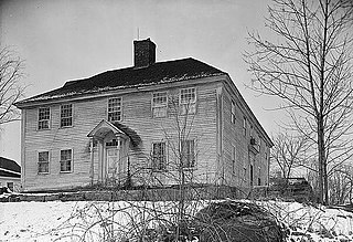
East Hardwick is an unincorporated village in the town of Hardwick, Caledonia County, Vermont, United States. It is part of what is known as the Northeast Kingdom (NEK) of Vermont. The community is located on the Lamoille River and along Vermont Route 16, 16 miles (26 km) west-northwest of St. Johnsbury. East Hardwick has a post office with ZIP code 05836, which opened on October 10, 1810. According to a 1937 WPA Federal Writers Project Guidebook, East Hardwick is a "side hill village spilling from the level of a plateau down a sharp incline in the valley of the Lamoille. It is surrounded by rich farm lands, Maple groves and forests."


