Tulare Lake, Laguna de Tache in Spanish, is a freshwater dry lake with residual wetlands and marshes in the southern San Joaquin Valley, California, United States. After Lake Cahuilla disappeared in the 17th century, Tulare Lake was the largest freshwater lake west of the Mississippi River and the second-largest freshwater lake entirely in the United States, based upon surface area. A remnant of Pleistocene-era Lake Corcoran, Tulare Lake dried up after its tributary rivers were diverted for agricultural irrigation and municipal water uses.
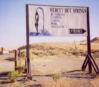
Mercey Hot Springs is an unincorporated community in the Little Panoche Valley of Fresno County, central California, about 60 miles (97 km) west-southwest of Fresno. It is a resort along South Fork Little Panoche Creek and the Little Panoche Road located at the western edge of Fresno County.
Ryer Island an island in the Sacramento-San Joaquin River Delta in Solano County, California surrounded by Miner Slough and Steamboat Slough at their confluence with the Sacramento River, 6.5 miles north-northeast of Rio Vista. The 4,750 ha (11,700-acre) island is named in honor of a California pioneer, Dr. Washington M. Ryer, and his family. A map prepared at the time of statehood shows the area divided by the west fork of the Sacramento River, with the western half identified as Priest Island and the eastern half identified as Sutter Island.

Fresno City is a former settlement in Fresno County, California. It was located at the head of navigation on Fresno Slough 2 miles (3.2 km) northwest of Tranquillity, at an elevation of 164 feet. The city was named after the Spanish word for the Oregon Ash trees that commonly grew along the river banks.

Herndon is an unincorporated community in Fresno County, California. It is located 9 miles (14 km) northwest of downtown Fresno, at an elevation of 299 feet.
Pueblo de las Juntas is a former settlement in Fresno County, California situated at the confluence of the San Joaquin River and Fresno Slough, 2 miles (3.2 km) north of Mendota.
Rancho de los Californios is a former settlement in Fresno County, California. It was located east of Pueblo de las Juntas on high ground near the south bank of the San Joaquin River. Its site is near the corner of Ashlan and North Lake Avenues, 4miles north of the Whitesbridge Road and 6 miles west of Biola, California.
Georgiana Slough, is a slough within Sacramento County, California. It is located in the Sacramento–San Joaquin River Delta, and links both the Sacramento River and the San Joaquin River above their confluence in the Delta near Pittsburg, at the head of Suisun Bay, through its connection with the Mokelumne River. The entrance to the slough on the Sacramento River is just below Walnut Grove, at 38°14′21″N121°30′59″W and runs between Tyler Island and Andrus Island to where it has its confluence with the Mokelumne River at 38°07′49″N121°34′40″W northwest of Bouldin Island just above that rivers confluence with the San Joaquin River.

William Helm was a sheep farmer and noteworthy among the early pioneer settlers of Fresno county.
Stockton–Los Angeles Road, also known as the Millerton Road, Stockton–Mariposa Road, Stockton–Fort Miller Road or the Stockton–Visalia Road, was established about 1853 following the discovery of gold on the Kern River in Old Tulare County. This route between Stockton and Los Angeles followed by the Stockton–Los Angeles Road is described in ITINERARY XXI. From Fort Yuma to Benicia, California, in The Prairie Traveler: A Hand-book for Overland Expeditions by Randolph Barnes Marcy. The Itinerary was derived from the report of Lieutenant R. S. Williamson on his topographical survey party in 1853, that was in search of a railroad route through the interior of California.
Poso de Chane or Poso Chane is a former settlement in Fresno County, California situated around the waterhole of that name, northwest just below the confluence of the Jacalitos Creek with Los Gatos Creek, 6 miles (9.7 km) east of Coalinga and northwest of the Guijarral Hills.
Cantua Creek, formerly in Spanish Arroyo de Cantúa, was named for José de Guadalupe Cantúa, a prominent Californio Ranchero in the 19th-century Mexican era of Alta California.
Temple's Ranch, was the ranch and a home of F. P. F. Temple, a wealthy land owner in Los Angeles County, with large business and land holdings of thousands of acres in Madera County and Fresno County including this ranch in Fresno County near the Merced County border.

Steamboats on the Colorado River operated from the river mouth at the Colorado River Delta on the Gulf of California in Mexico, up to the Virgin River on the Lower Colorado River Valley in the Southwestern United States from 1852 until 1909, when the construction of the Laguna Dam was completed. The shallow draft paddle steamers were found to be the most economical way to ship goods between the Pacific Ocean ports and settlements and mines along the lower river, putting in at landings in Sonora state, Baja California Territory, California state, Arizona Territory, New Mexico Territory, and Nevada state. They remained the primary means of transportation of freight until the advent of the more economical railroads began cutting away at their business from 1878 when the first line entered Arizona Territory.

John Gunder North was a Norwegian born, ship builder in San Francisco. During his career, he built 273 hulls of all kinds with 53 bay and river steamers, including the famed paddle steamers Chrysopolis, Yosemite and Capital.
Georgiana, a small side-wheel steamboat made in Philadelphia in 1849, one of the first on the waters of the Mokelumne River, Sacramento, San Joaquin and Tuolumne Rivers of California.
Steamboats operated in California on San Francisco Bay and the Sacramento–San Joaquin River Delta, and Sacramento River as early as November 1847, when the Sitka built by William A. Leidesdorff briefly ran on San Francisco Bay and up the Sacramento River to New Helvetia. After the first discovery of gold in California the first shipping on the bays and up the rivers were by ocean going craft that were able to sail close to the wind and of a shallow enough draft to be able to sail up the river channels and sloughs, although they were often abandoned by their crews upon reaching their destination. Regular service up the rivers, was provided primarily by schooners and launches to Sacramento and Stockton, that would take a week or more to make the trip.
El Dorado was a 153 ton side-wheel steamship, was ordered by Captain J. W. Wright and built by Thomas Collver, it was originally to be named Caribbean, however she was sold while still on the stocks to Howland & Aspinwall, who were building up a fleet of steamers on the Atlantic Ocean.