Benton County is a county in the south-central portion of the U.S. state of Washington. As of the 2010 census, its population was 175,177. The county seat is Prosser, and its largest city is Kennewick. The Columbia River demarcates the county's north, south, and east boundaries.

Selah is a city in Yakima County, Washington, United States. The population was 7,147 at the 2010 census.

The Yakama are a Native American tribe with nearly 10,851 members, based primarily in eastern Washington state.

The Yakama Indian Reservation is a Native American reservation in Washington state of the federally recognized tribe known as the Confederated Tribes and Bands of the Yakama Nation. The tribe is made up of Klikitat, Palus, Wallawalla, Wanapam, Wenatchi, Wishram, and Yakama peoples.

The Columbia River drainage basin is the drainage basin of the Columbia River in the Pacific Northwest region of North America. It covers 668,000 km2 or 258,000 sq mi. In common usage, the term often refers to a smaller area, generally the portion of the drainage basin that lies within eastern Washington.

The Hanford Reach National Monument is a national monument in the U.S. state of Washington. It was created in 2000, mostly from the former security buffer surrounding the Hanford Nuclear Reservation. The area has been untouched by development or agriculture since 1943. Because of that it is considered an involuntary park.
The Yakima Valley AVA was the first American Viticultural Area established within Washington State, gaining the recognition in 1983. Part of the larger Columbia Valley AVA, Yakima Valley AVA is home to more than 11,000 acres (45 km2) of vineyards, giving the area the largest concentration of wineries and vineyards in the state of Washington. The most widely planted varietals in the area are Chardonnay, Riesling, Merlot, Cabernet Sauvignon, Pinot gris, and Syrah. Nearly 40% of Washington state yearly wine production is made from Yakima Valley grapes. In addition to grapes, the Yakima Valley is also home to several fruit orchards growing apples, cherries, nectarines, peaches, pears and plums. Around the town of Zillah, there is the Zillah Fruit Loop driving tour through the area's orchards and vineyards. The area is also home to nearly 80% of the US hop production.
The Rattlesnake Hills AVA is an American Viticultural Area located in Yakima County, Washington. United States Alcohol and Tobacco Tax and Trade Bureau (TTB) awarded Rattlesnake Hills its appellation status on March 20, 2006, making Rattlesnake Hills Washington's ninth federally recognized American Viticultural Area. The Rattlesnake Hills AVA is entirely contained within the Yakima Valley AVA, which is in turn is entirely contained within the larger Columbia Valley AVA. The hills form the northern boundary of Yakima Valley, and the AVA includes land between the north bank of the Sunnyside Canal and the entirety of the southern slopes of the Rattlesnake Hills between Outlook and the Wapato Dam. The AVA is centered on the city of Zillah. With elevations ranging from 850 feet (259 m) to 3,085 feet (940 m), this AVA contains the highest point in the Yakima Valley AVA

Parker Field is a 2,500-seat baseball stadium in the northwest United States, located in Yakima, Washington. Opened 82 years ago in 1937 for the Yakima Pippins of the Western International League, it hosted various professional and amateur teams in the area prior to the opening of Yakima County Stadium in 1993.
State Route 821 (SR 821) is a state highway in central Washington state. It runs for 25 miles (40 km) through the Yakima Canyon, following the meandering Yakima River between Selah and Ellensburg. Both ends of the highway are at interchanges with Interstate 82 (I-82) and U.S. Route 97 (US 97).
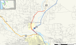
State Route 823 (SR 823) is a state highway in Yakima County, Washington, United States. It runs for 5.6 miles (9.0 km) from an interchange with U.S. Route 12 (US 12) and through the city of Selah to a junction with SR 821. The highway intersects and runs in the median of Interstate 82 (I-82), its parent route.
Snipes Mountain AVA is an American Viticultural Area located in the Yakima Valley of Washington State. It was approved by the Bureau of Alcohol, Tobacco, Firearms and Explosives on January 21, 2009 making it Washington's 10th federally designated AVA. It is the second smallest AVA in the state, after the Red Mountain AVA, and has one of the state's longest viticultural histories. The 4,145 acres (1,677 ha) appellation is a sub-AVA of the Yakima Valley AVA and the Columbia Valley AVA. It is located above and between the towns of Sunnyside and Granger around Outlook, Washington, in the southeast corner of the Yakima Valley.
West Valley High School is a public secondary school in Yakima, Washington, United States, in the West Valley School District. It consists of two adjacent campuses: the main campus for sophomores, juniors, and seniors, and a freshman campus located next to Gotfred E. Clasen field. The school enrolls approximately 1,400 students.
Willow Creek Wildlife Area, located in northeastern Oregon, United States, near the Columbia River, is operated by the Oregon Department of Fish and Wildlife. Birds watchers may find birds of prey, waterfowl, wading birds, songbirds and shorebirds.
Yakima Valley College (YVC) is a community college based in Yakima, Washington.
Nanticoke Wildlife Area is a state wildlife area located in Sussex County, Delaware, along the Nanticoke River and Broad Creek, near to Seaford, Delaware, and Bethel, Delaware. There is a monument commenmorating Captain John Smith's journey into the Chesapeake Bay and its tributaries at Phillips Landing along Broad Creek, a tributary of the Nanticoke River in Delaware. It is made up of three large land tracts totaling 4,510 acres (1,825 ha), it is managed by Delaware Department of Natural Resources and Environmental Control (DNREC), Division of Fish and Wildlife.
The Yakima River Delta is an area of land in Richland, Washington where the Yakima River enters the Columbia River at River Mile 335. It hosts several protected areas and is crossed by State Route 240. This area is mostly floodplain with riparian-type growth, including non-native species such as Russian olive. Amon Creek enters the Yakima River in this area.

The 2018 Washington wildfire season officially began June 1, 2018. A statewide state of emergency was declared by the Washington State Governor on July 31.
Selah Gap is a water gap carved by the Yakima River through the Yakima Ridge basalt formation between Yakima, Washington and Selah, Washington. The gap is traversed by BNSF Railway, Interstate 82, and Washington State Route 823. The Yakima Greenway trail for non motorized users also crosses the Yakima River at Selah Gap on an 1884 railroad bridge. The William O. Douglas Trail, named for William O. Douglas who hiked there from his home in Yakima, also crosses the gap and ascends the ridge on its way to Mount Rainier.