
The Macquarie Lighthouse, also known as South Head Upper Light, is the first, and is the longest serving, lighthouse site in Australia. It is located on Dunbar Head, on Old South Head Road, Vaucluse in the Municipality of Woollahra local government area of New South Wales, Australia. The lighthouse is situated approximately 2 kilometres (1 mi) south of South Head near the entrance to Sydney Harbour. There has been a navigational aid in this vicinity since 1791 and a lighthouse near the present site since 1818. The current heritage-listed lighthouse was completed in 1883. The lighthouse and associated buildings were designed by James Barnet and built from 1881 to 1883.
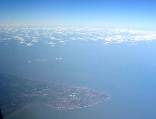
North Foreland is a chalk headland on the Kent coast of southeast England, specifically in Broadstairs.

Hornby Lighthouse, also known as South Head Lower Light or South Head Signal Station, is a heritage-listed active lighthouse located on the tip of South Head, New South Wales, Australia, a headland to the north of the suburb Watsons Bay. It marks the southern entrance to Port Jackson and Sydney Harbour, as well as lighting the South Reef, a ledge of submerged rocks. It is the third oldest lighthouse in New South Wales. Designed by Mortimer Lewis and listed on the Register of the National Estate and on the New South Wales State Heritage Register since 2 April 1999, with the following statement of significance:
A dominant Sydney landmark which appears to have been in continuous use since the 1840s as a controlling point for shipping entering and leaving Port Jackson. The building complex, designed by the Colonial Architect Mortimer Lewis in the early 1840s, is an architectural important example of an early Victorian public work associated with port activities.

Whiteford Point Lighthouse is located off the coast at Whiteford Point near Whiteford Sands, on the Gower Peninsula, south Wales.

The first Saginaw River lighthouse was constructed from 1839 to 1841, in a period when large quantities of lumber were being harvested and shipped from the heart of Michigan via river and the Great Lakes to the East Coast of the United States via the Erie Canal and Hudson River. This connection to major eastern markets was critical to the development of central Michigan.

The Three Sisters of Nauset are a trio of historic lighthouses off Cable Road in Eastham, Massachusetts. The original three brick towers fell into the sea due to erosion in 1890 and were replaced with wooden towers on brick foundations in 1892. The Sisters were decommissioned in 1911 but one of them, the Beacon, was moved back from the shoreline and attached to the keeper's house. It continued to operate but was replaced by a new steel tower, the Nauset Light, in 1923.

Smoky Cape Lighthouse is a heritage-listed active lighthouse located on Smoky Cape, a headland in Arakoon east of the town of South West Rocks, Kempsey Shire, New South Wales, Australia, and within the Hat Head National Park. It directs boats towards the entrance to the Macleay River, which is located just to the north of the lighthouse.

Round Island Passage Light is an automated, unmanned lighthouse located in the Round Island Channel in the Straits of Mackinac, Michigan. The channel is a branch of Lake Huron.

Point Lonsdale Lighthouse, also known as the Point Lonsdale Signal Station, is close to the township of Point Lonsdale in the Borough of Queenscliffe, Victoria, Australia. It stands at the eastern end of the Bellarine Peninsula, on the western side of the entrance to Port Phillip from Bass Strait, on a headland overlooking the "Rip", a stretch of water considered one of the ten most treacherous navigable passages in the world, and the only seaborne approach to Melbourne. It is operated by Victorian Ports Corporation (Melbourne).

Richmond River Light, also known as Ballina Head Light and Ballina Light, is an active lighthouse located at Ballina Head, a headland in Ballina, New South Wales, Australia. The headland is at the northern side of the entrance to the Richmond River. It used to serve to guide ships into the river port and is used also serves as a leading light into the river, together with a steamer's masthead lantern with a 200 mm lens which is raised on a wooden structure 30 metres (98 ft) from it.

Fingal Head Light is an active lighthouse located at Fingal Head, New South Wales, Australia, a headland about 5 kilometres (3.1 mi) south of Point Danger, which marks the Queensland border.
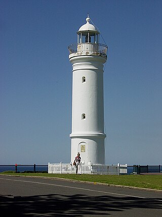
Kiama Light, also known as Kiama Harbour Light, is an active lighthouse in Kiama, New South Wales, Australia. The lighthouse is located close to the Kiama Blowhole on Blowhole Point, south of Kiama Harbour.

Norah Head Light is an active lighthouse located at Norah Head, a headland on the Central Coast, New South Wales, Australia, close to Toukley. It is the last lighthouse of the James Barnet style to be built, and the last staffed lighthouse constructed in New South Wales.

Parriwi Head Light, also known as Rosherville Light and Port Jackson Entrance Range Rear Light, is an active lighthouse located just off Parriwi Road, near Rosherville Reserve on the south side of Middle Harbour in Mosman, New South Wales, Australia. It serves as the rear range light, Grotto Point Light serving as the front light, into Port Jackson. Grotto Point Light is located almost exactly 1 mile (1.6 km) in front of Parriwi Head Light.

Clarence River Light, also known as Yamba Light or Clarence Head Light, is an active lighthouse located on Pilot Hill, a hill in Wooli Park, Yamba, New South Wales, Australia, south of the entrance of Clarence River. The current lighthouse was built in 1955, replacing a previous lighthouse built in 1880. It serves as the rear range light for two different ranges.

Watwick Point Beacon is a leading light, which is a type of lighthouse, located near Dale, Pembrokeshire, in Wales. It is designed to lead ships into Milford Haven in conjunction with the West Blockhouse Point Beacons. It is situated about half a mile to the north-east of West Blockhouse Point.

Booby Island Light is an active heritage-listed lighthouse located on Booby Island in the Shire of Torres, near the tip of Cape York Peninsula, west of Prince of Wales Island, within the Endeavour Strait, Queensland, Australia. It marks the western entrance to the navigation channel through the Torres Strait. It was the last of the major lights to be constructed along the Queensland coast.

Point Danger Light, also known as the Captain Cook Memorial Light, is an active lighthouse located on Point Danger, a headland between Coolangatta and Tweed Heads, marking the border between Queensland and New South Wales, Australia. It lays claim to be the first lighthouse in the world to experiment with laser as a light source.
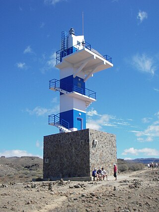
The Punta del Castillete Lighthouse is an active lighthouse on the Canary island of Gran Canaria. It is located on cliffs above the resort and fishing harbour of Puerto de Mogán, in the municipality of Mogán. Punta Castillete is on the south-western side of the island facing the Atlantic Ocean, and lies between Maspalomas Lighthouse to the south and the lighthouse of Punta Sardina to the north.

West Blockhouse Fort is a mid-19th century coastal artillery fort at West Blockhouse Point, a rocky headland near Dale, Pembrokeshire, to the west of Milford Haven in Wales.


