Originally a Dutch village, formally organized in 1658,[3] Harlem is named after the city of Haarlem in the Netherlands. Its history has been defined by a series of economic boom-and-bust cycles, with significant population shifts accompanying each cycle.[4] Harlem was predominantly occupied by Jewish and Italian Americans in the late 19th century, while African-American residents began to arrive in large numbers during the Great Migration in the early 20th century. In the 1920s and 1930s, Central and West Harlem were the center of the Harlem Renaissance, a major African-American cultural movement. With job losses during the Great Depression of the 1930s and the deindustrialization of New York City after World War II, rates of crime and poverty increased significantly.[5] In the 21st century, crime rates decreased significantly, and Harlem started to gentrify.
Throughout the nineteenth century, West Harlem bustled around a wharf active with ferry and daily river conveyances. It was the first station on the Hudson River Railroad running north from the city, and the hub of daily stage coach, omnibus and streetcar lines. Situated near Bloomingdale Road, its hotels, houses of entertainment and post office made it an alluring destination of suburban retreat from the city, yet its direct proximity to the Hudson River also made it an invaluable industrial entry point for construction materials and other freight bound for Upper Manhattan. With the construction of road and railway viaducts over the valley in which the town sat, Manhattanville, increasingly absorbed into the growing city, became a marginalized industrial area. In the early 2000s, the neighborhood became the site of a major planned expansion of Columbia University, with its Manhattanville campus now located in the neighborhood.[6] The campus consists of the Forum, the Lenfest Center for the Arts (including the Miriam and Ira D. Wallach Art Gallery), and the Jerome L. Greene Science Center. The Henry Kravis Hall and the Ronald O. Perelman Center were being built, as of 2018[update],[7] with the former being completed in 2022 and housing the Columbia Business School.[8]
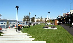
West Harlem Piers
West Harlem Piers
Construction of the West Harlem Piers Waterfront park began in April 2006, after a groundbreaking ceremony in November 2005.[9] The park, funded by the New York City Economic Development Corporation and designed by W Architecture and Landscape Architecture,[citation needed] includes a fishing pier, a kayak launch (non-functional since before 2019), sculptures, and water taxi landings (but no water taxis). Stretching from 125th Street to 132nd Street, partly on land formerly used as a parking lot, it is one of a series of contemporary landscape architecture projects (including the High Line and Brooklyn Bridge Park) that reclaim obsolete infrastructure as public space. The piers formerly served ferries including the Public Service Corporation link to Edgewater, New Jersey. The park closed a gap in the Manhattan Waterfront Greenway that runs along the western side of Manhattan Island and will later connect up the Hudson River. It opened in early October 2008.[10] The area that surrounds the park and piers is at times called ViVa (Viaduct Valley).
↑Pierce, Carl Horton, et al. New Harlem Past and Present: the Story of an Amazing Civic Wrong, Now at Last to be Righted. New York: New Harlem Pub. Co., 1903.
↑"Harlem History |". Harlemworldmag.com. January 26, 1934. Archived from the original on December 13, 2012. Retrieved February 2, 2013.
This page is based on this Wikipedia article Text is available under the CC BY-SA 4.0 license; additional terms may apply. Images, videos and audio are available under their respective licenses.