
Hot Springs is a resort city in the state of Arkansas and the county seat of Garland County. The city is located in the Ouachita Mountains among the U.S. Interior Highlands, and is set among several natural hot springs for which the city is named. As of the 2020 United States Census, the city had a population of 37,930.

This is a list of properties and historic districts in Arkansas that are listed on the National Register of Historic Places. There are more than 2,600 listings in the state, including at least 8 listings in each of Arkansas's 75 counties.

The former First Church of Christ, Scientist, now the Little Rock Community Church, is a historic church building at 2000 South Louisiana Street in Little Rock, Arkansas. It is a single-story Mission style building, designed by noted Arkansas architect John Parks Almand and completed in 1919. Characteristics of the Mission style include the low-pitch tile hip roof, overhanging eaves with exposed rafter ends, and smooth plaster walls. The building also has modest Classical features, found in pilaster capitals and medallions of plaster and terra cotta. The building is local significant for its architecture. It was built for the local Christian Science congregation, which in 1950 sold it to an Evangelical Methodist congregation. That congregation has since severed its association with the Evangelical Methodist movement, and is now known as the Little Rock Community Church.

The Governor's Mansion Historic District is a historic district covering a large historic neighborhood of Little Rock, Arkansas. It was listed on the National Register of Historic Places in 1978 and its borders were increased in 1988 and again in 2002. The district is notable for the large number of well-preserved late 19th and early 20th-century houses, and includes a major cross-section of residential architecture designed by the noted Little Rock architect Charles L. Thompson. It is the oldest city neighborhood to retain its residential character.
The University of Arkansas Campus Historic District is a historic district that was listed on the National Register of Historic Places on September 23, 2009. The district covers the historic core of the University of Arkansas campus, including 25 buildings.
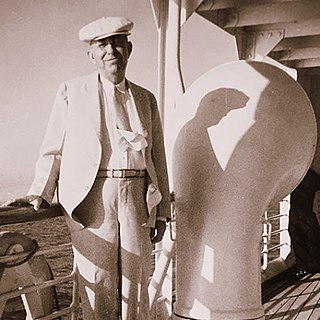
Justin Matthews (1876–1955) was an Arkansas road and bridge builder and real estate developer. He helped to design and expand many areas in central Arkansas.

The Mahony Historic District encompasses a residential part of El Dorado, Arkansas north of its downtown area. It was an area of significant development in the years after the 1921 discovery of oil and the ensuing economic boom. The area is bounded on the south by Champagnolle Road, on the west by a line just east of North Madison Avenue, on the north by East 5th Street, and on the east by North Lee Avenue and railroad tracks. It is just over 14 acres (5.7 ha) in size, and includes 94 buildings that contribute to its significance. The streets in the district are laid out in grid form, accounting for the fact that Champagnolle Road runs diagonally from southwest to northeast. Most of the housing in the district consists of modest single-story houses, with simple styling. This is a contrast to the adjacent Murphy-Hill Historic District, a more affluent area with a longer history of development. Only five houses in the district were built before 1920, and all lie on Champagnolle Road; most of the rest were built in the decade after the oil discovery. There is one church in the district, St. Mary's Episcopal Church, completed in 1950. The district was listed on the National Register of Historic Places in 2011.

The Charlotte Street Historic District encompasses a historic residential subdivision in Fordyce, Arkansas. The district extends along Charlotte Street between Holmes and East 4th Streets, and includes a few properties on Broadway, as well as the remaining grounds of the estate of A. B. Banks, an insurance company owner who oversaw the area's development in the 1920s. The area originally consisted of a large tract of land outside the city, which was annexed to it in 1906. Charlotte Street was named for Banks' wife, and he had a handsome estate house built on this land which was designed by Charles L. Thompson, which burned in 1964. Many features of the estate, located between Broadway and East 4th, have been retained, including an inground swimming pool that was supposedly the first private pool in the state.

The Southwestern Proving Ground Officers Quarters Historic District is a residential historic district encompassing most of the town of Oakhaven, Arkansas. Located at the western end of Oakhaven Road, the district includes 20 houses built in 1941 to provide housing for military officers serving at the Southwestern Proving Ground, of which this area was then a part. After World War II came to an end, the properties were sold off to local veterans, who incorporated Oakhaven soon afterward. The houses are all two story wood-frame structures resting on brick foundations. Most of the houses have hip roofs, although those reserved for the highest-ranking officers had gable roofs. They are typically three bays wide with a center entry, and feature modest Colonial Revival styling.

The Nashville Commercial Historic District encompasses much of the historic downtown commercial area of Nashville, Arkansas, and the major commercial center in Howard County. It is centered at the junction of Main and Howard Streets, extending eastward along East Howard, and north and south along Main Street for about one block. Most of the buildings in the district are tall single-story brick structures, some covered in stucco. They were built between about 1895 and the 1930s, with a smaller number appearing later. The area's economic activity was driven first by the arrival of the railroad, which defined the layout of the town, and then by the growth of lumber and agriculture in the region. The oldest building in the district is 203 North Main, built c. 1895 with modest Romanesque Revival styling.

The DeWitt Post Office in DeWitt, Arkansas is a historic post office building at 221 West Cross Street. It is a modest single-story brick and masonry structure with a hip roof, built in 1939 in a restrained Colonial Revival style. It is basically rectangular structure, with a loading dock area projecting from the center of the rear. The building is notable for the murals in its lobby area, painted by William Traher of Denver, Colorado, and paid for with funds from the United States Treasury Department's Section of Fine Arts, a Depression-era project to support artists.

The School Addition Historic District encompasses a middle-class residential area of Batesville, Arkansas that typifies its growth between about 1850 and 1950. It is located between Main Street and Poke Bayou, along two blocks each of Rock and Water Streets, and the intervening blocks of 7th and 8th Streets. Houses in this area are generally of a modest scale, built for tradesmen and craftsmen. They come in a variety of styles, including the traditional I-house, American Craftsman-style bungalows, and ranches. The district was platted out in 1849 and sold off by the town to raise funds for public education.
The Dr. Hudson Sanitarium Agricultural Building Historic District encompasses a small cluster of buildings constructed in the 1930s as part of a planned tuberculosis sanitarium in central northern Newton County, Arkansas. It is located on the west side of Arkansas Highway 327, southwest of Jasper, and includes three buildings. Two of them are modest 1+1⁄2-story log houses, finished with board-and-batten siding, and the third is a two-story wood-frame dairy barn. These were built 1936-39 pursuant to a plan by Dr. William Anderson Hudson, a doctor with deep family ties in the area, to provide facilities for tuberculosis sufferers in the remote area. His plans were frustrated by World War II and state regulations on such facilities, and the main sanitarium was never built.
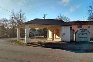
The Mount Ida Cities Service Filling Station is a historic automotive service station at 204 Whittington Street in Mount Ida, Arkansas. It is a small five-sided frame structure, finished in brick covered with stucco, with a hip roof that extends to form a canopy over the service area, with supporting brick piers at the far corners. Its front has fixed four-pane windows flanking a center entrance. Built in 1925 by Cities Service, it was used as a gas station until 1966, and has since housed a variety of small businesses. Its role as a gas station was briefly resurrected in the film White River Kid, which was shot here in 1998.
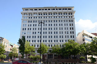
The Capitol–Main Historic District encompasses a well-preserved area of early 19th-century commercial architecture in downtown Little Rock, Arkansas. The district includes 2-1/2 blocks of Capitol Street, extending east from Center Street, one block of Main Street south of Capitol, and one block of 6th Street west of Main. The buildings in this area were mostly built before World War II, and are of a more modest scale than modern sections of the downtown. Notable buildings include the LaFayette Hotel and the Pfeifer Brothers Department Store.
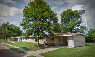
The Blytheville Air Force Base Capehart Housing Historic District encompasses a large residential area built between 1957 and 1962 as part of a military housing program for service members stationed at the now-closed Blytheville Air Force Base in Blytheville, Arkansas. This area was developed pursuant to guidelines established by the Federal Housing Administration (FHA), and is laid out with curvilinear roads meeting in three-way intersections, specified lot sizes and setback requirements, and a small number of building designs with a modest number of exceptions. The construction program under which this area was developed was named for Senator Homer Capehart, principal sponsor of the bill authorizing it. The area is roughly bounded by Memorial Drive, Village and Westminster Avenues, and Northside, and has more than 400 residences, most of which are single-story duplex ranches.

The Lincoln Building is a historic commercial building at 1423-25 South Main Street in Little Rock, Arkansas. It is a two-story brick structure, built in 1905 with modest Neoclassical design elements, including bays articulated by brick pilasters with metal Corinthian capitals. It was built as a speculative real estate venture by C. J. Lincoln, a local drugstore wholesaler, and is one of the South Main Street area's best examples of the style.

The South Scott Street Historic District encompasses a small portion of a residential area south of downtown Little Rock, Arkansas. It includes the 2400 block of South Scott Street, and one block of 24th Street just to its west. Developed between about 1890 and 1950, this area has one of the city's best-preserved concentrations of modest middle-class residences from that period. It includes fourteen buildings, ranging stylistically from the Queen Anne to the post-World War II vernacular.

The West Newbury Village Historic District encompasses the modest rural country village of West Newbury, Vermont. It is located at the junction of Tucker Mountain, Snake, and Tyler Farm Roads, and is relatively little altered since its 19th-century development. It was listed on the National Register of Historic Places in 1983.

The Fitzgerald Historic District is a residential historic district located southeast of the central business district of Fort Smith, Arkansas. The district is roughly bounded by Rogers & Dodson Avemies, South I, S 22nd, and South 25th Streets, and covers 22 acres (8.9 ha). The neighborhood was developed after about 1906, as an area of affordable homes for working and middle class residents. It was built mainly on land sold of by Bishop Edward Fitzgerald of the local Roman Catholic diocese. Most of the buildings in the district are modestly scaled and decorated examples of Revival styles popular in the first three decades of the 20th century. The district is adjacent to the Fishback Neighborhood Historic District, which was developed about the same time.


