The National Register of Historic Places (NRHP) is the United States federal government's official list of districts, sites, buildings, structures and objects deemed worthy of preservation for their historical significance or "great artistic value". A property listed in the National Register, or located within a National Register Historic District, may qualify for tax incentives derived from the total value of expenses incurred in preserving the property.

Gales Ferry is a village in the town of Ledyard, Connecticut, United States. It is located along the eastern bank of the Thames River. The village developed as a result of having a ferry to Uncasville located at this site, and from which the village was named. Gales Ferry was listed as a census-designated place for the 2010 Census, with a population of 1,162.

In the law regulating historic districts in the United States, a contributing property or contributing resource is any building, object, or structure which adds to the historical integrity or architectural qualities that make the historic district significant. Government agencies, at the state, national, and local level in the United States, have differing definitions of what constitutes a contributing property but there are common characteristics. Local laws often regulate the changes that can be made to contributing structures within designated historic districts. The first local ordinances dealing with the alteration of buildings within historic districts was passed in Charleston, South Carolina in 1931.

Coal Run is an unincorporated community in northeastern Waterford Township, Washington County, Ohio, United States. It has a post office with the ZIP code 45721. It is located along State Route 60 between the villages of Beverly and Lowell. The Muskingum River flows past the community.
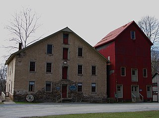
Prallsville is an unincorporated community located along New Jersey Route 29 by the border of Stockton and Delaware Township in Hunterdon County, New Jersey. The Delaware River and Wickecheoke Creek border the community. The Prallsville District was listed on the National Register of Historic Places in 1979.
The Green River Shell Middens Archeological District is a historic district composed of archaeological sites in the U.S. state of Kentucky. All of the district's sites are shell middens along the banks of the Green River that date from the later portion of the Archaic period. Studies of this assemblage of sites were critical in the development of knowledge of the Archaic period in the eastern United States.
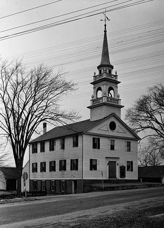
Preston City is a village and the original town center of the town of Preston, Connecticut. The core of the village around the junction of Old Northwest Road and Route 164 is designated as the Preston City Historic District, a historic district that is listed on the National Register of Historic Places. The district is located along Old Shetucket and Amos Roads, which, prior to the 1930s, were major thoroughfares.

The Newtown Borough Historic District is a 100-acre (40 ha) historic district in the borough of Newtown within the town of Newtown in Fairfield County, Connecticut. There is a local historic district, and an overlapping district that was listed on the National Register of Historic Places in 1996.

Hebron Center Historic District encompasses most of the historic village center of Hebron, Connecticut. Centered on the junction of Connecticut Routes 66 and 85, it has served as the rural community's civic center since its incorporation in 1708. The district was listed on the National Register of Historic Places in 1993.

Little York is an unincorporated community located along the border of Alexandria and Holland townships in Hunterdon County, New Jersey, United States. Little York is located on County Route 614 3.1 miles (5.0 km) north-northeast of Milford. Little York has a post office with ZIP code 08834.

The Mantle Rock Archeological District, near Smithland, Kentucky is a 215 acres (0.87 km2) historic district which was listed on the National Register of Historic Places in 2004.
The Monterey Historic District in Monterey, Kentucky is a historic district which was listed on the National Register of Historic Places in 1997.

The New Liberty Historic District in New Liberty, Kentucky is a 29.5 acres (11.9 ha) historic district which was listed on the National Register of Historic Places in 2001. It is located along Kentucky Route 227, roughly between KY 978 and KY 36.

The Irvine Historic Business District in Irvine, Kentucky is a historic district which was listed on the National Register of Historic Places in 2000.
The Central Avenue Historic District in Pewee Valley, Kentucky is a 40 acres (16 ha) historic district which was listed on the National Register of Historic Places in 1989. It included 21 contributing buildings, two contributing structures, and a contributing site.
The Sulphur Well Historic District is an 81 acres (33 ha) historic district in Sulphur Well, Kentucky which was listed on the National Register of Historic Places in 1998.

The Bill Monroe Farm is a historic farm attributed to being the birthplace of Bill Monroe, creator of the bluegrass music genre. The farm is 1,000 acres (4.0km²) and is located near Rosine in Ohio County, Kentucky. It was listed on the National Register of Historic Places in 2003.
The Pisgah Rural Historic District, in Fayette and Woodford counties near Versailles, Kentucky, is a 4,035 acres (16.33 km2) historic district which was listed on the National Register of Historic Places in 1989.
The Middle Reaches of Boone Creek Rural Historic District in the Clark County, Kentucky and Fayette County, Kentucky is a historic district which was listed on the National Register of Historic Places in 1996.
The Stoner Creek Rural Historic District, in Bourbon County, Kentucky near Paris, Kentucky, is a 22,000 acres (89 km2) historic district which was listed on the National Register of Historic Places in 2001.


