
Mark Twain National Forest (MTNF) is a U.S. National Forest located in the southern half of Missouri. MTNF was established on September 11, 1939. It is named for author Mark Twain, a Missouri native. The MTNF covers 3,068,800 acres (12,419 km2) of which 1,506,100 acres (6,095 km2) is public owned, 78,000 acres (320 km2) of which are Wilderness, and National Scenic River area. MTNF spans 29 counties and represents 11% of all forested land in Missouri. MTNF is divided into six distinct ranger districts: Ava-Cassville-Willow Springs, Eleven Point, Houston-Rolla, Cedar Creek, Poplar Bluff, Potosi-Fredericktown, and the Salem. The six ranger districts actually comprise nine overall unique tracts of forests. Its headquarters are in Rolla, Missouri.
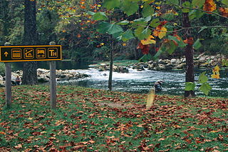
Bennett Spring State Park is a public recreation area located in Bennett Springs, Missouri, twelve miles (19 km) west of Lebanon on Highway 64 in Dallas and Laclede counties. It is centered on the spring that flows into the Niangua River and gives the park its name. The spring averages 100 million gallons of daily flow. The park offers fly fishing, camping, canoeing, hiking, and other activities.

Cuivre River State Park is a public recreation area covering more than 6,400 acres (2,600 ha) northeast of the city of Troy in the Lincoln Hills region of northeastern Missouri, United States. The state park's rugged landscapes range from native grasslands and savannas to limestone bluffs over looking forested hills. The park offers an extensive system of hiking trails plus swimming and camping facilities and is managed by the Missouri Department of Natural Resources. It encompasses the Lincoln Hills Natural Area and two designated wild areas: Big Sugar Creek and Northwoods.

The North Entrance Road Historic District comprises Yellowstone National Park's North Entrance Road from Gardiner, Montana to the park headquarters at Mammoth Hot Springs, Wyoming, a distance of a little over five miles (8 km). The North Entrance Road was the first major road in the park, necessary to join the U.S. Army station at Fort Yellowstone to the Northern Pacific Railroad station at Gardiner. The road includes the Roosevelt Arch at the northern boundary of the park and winds through rolling terrain before crossing the Gardner River and joining the Grand Loop Road.

The White Grass Ranger Station includes several structures in the backcountry of Grand Teton National Park that were established to support horse patrols by park rangers. Built in 1930, White Grass is the only surviving horse patrol station in the park. The station, which includes a cabin, several sheds and a corral, was built to a standardized National Park Service plan, in the National Park Service rustic style.

The Upper Lake McDonald Ranger Station in Glacier National Park was a formerly isolated site that became an administrative center with the opening of the Going-to-the-Sun Road. The National Park Service Rustic cabin was typical of the preferred style for western park structures of the period. The ranger station is similar to its counterparts at Belly River and Sherburne, as well as the Polebridge Ranger Station residence.

The Sherburne Ranger Station in Glacier National Park is an example of the National Park Service Rustic style. Located in the Swiftcurrent portion of the park, it was built in 1926. It is part of a small historic district that includes a mess hall and subsidiary structures, formerly known as the Sherburne Road Camp, established in 1931. The ranger station closely resembles the ranger stations at Belly River and Lake McDonald. A checking station at the road remains substantially intact.

The Swiftcurrent Ranger Station is an example of the Swiss Chalet style that prevailed in the early years of Glacier National Park, before the establishment of the similar National Park Service Rustic style. The station was designed by Edward A. Nickel and built by Ole Norden and S. M. Askevold. It replaced a previous ranger station, destroyed in a 1936 forest fire. All structures in the district were built within a single year and are consistent in design and materials.

This is a list of the National Register of Historic Places listings in Winona County, Minnesota. It is intended to be a complete list of the properties and districts on the National Register of Historic Places in Winona County, Minnesota, United States. The locations of National Register properties and districts for which the latitude and longitude coordinates are included below, may be seen in an online map.

The Nisqually Entrance Historic District comprises the first public entrance to Mount Rainier National Park. The district incorporates the log entrance arch typical of all Mount Rainier entrances, a log frame ranger station and checking station, a comfort station and miscellaneous service structures, all built around 1926, as well as the 1915 Superintendent's Residence and the 1908 Oscar Brown Cabin, the oldest remaining structure in the park. The buildings in the district conform to the principles of the National Park Service Rustic style that prevailed in park design of the 1920s and 1930s.
The Butte Falls Ranger Station, located in Rogue River – Siskiyou National Forest in Butte Falls, Oregon, was built in 1935 by the Civilian Conservation Corps. It was designed by architects of the United States Forest Service in rustic style.
Architects of the National Park Service are the architects and landscape architects who were employed by the National Park Service (NPS) starting in 1918 to design buildings, structures, roads, trails and other features in the United States National Parks. Many of their works are listed on the National Register of Historic Places, and a number have also been designated as National Historic Landmarks.
Midwest Rail Rangers is a non-profit organization specializing with on-board educational programs to railroad passengers in the Midwestern United States with information regarding history, ecology, and geology.
Cassville Ranger Station Historic District is a national historic district near Cassville, Barry County, Missouri. It encompasses five frame and limestone buildings constructed by Civilian Conservation Corps in 1936:

Big Spring Historic District is a national historic district located at Van Buren, Carter County, Missouri. It encompasses 26 contributing buildings, 1 contributing site, and contributing structure in the Ozark National Scenic Riverways. It includes the Big Spring, rental cabins, service building, storage shed, garage, a museum, dining lodge, restroom, shelter house, ranger station, pump house, footbridge, and two picnic shelters. The structures represent the best features of park construction by the Civilian Conservation Corps in Missouri.

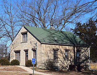
Ava Ranger Station Historic District is a national historic district located near Ava, Douglas County, Missouri. The district encompasses five frame and limestone buildings constructed by Civilian Conservation Corps in 1936. They are the 1 1/2-story, Colonial Revival style Ranger's Office; 1 1/2-story, Colonial Revival style Ranger's Dwelling; garage; warehouse and an oil house. It continues to be used as a Ranger Station for the Mark Twain National Forest.
Rolla Ranger Station Historic District is a historic ranger station and national historic district located at Mark Twain National Forest near Rolla, Phelps County, Missouri. The station includes five frame and limestone buildings constructed by the Civilian Conservation Corps (CCC) during 1937 and 1938. They were built under the supervision of a Works Progress Administration (WPA) project. They are a ranger's office, dwelling, garage, warehouse and oil house. The ranger's office and dwelling are 1 1/2-story, Colonial Revival influenced buildings.
Houston Ranger Station Historic District is a national historic district located in Mark Twain National Forest near Houston, Texas County, Missouri. The district encompasses five frame and limestone buildings constructed by the Lynchburg Camp of the Civilian Conservation Corps (CCC) during 1936 and 1937. They are the 1 1/2-story Colonial Revival style ranger's office, 1 1/2-story Colonial Revival style dwelling, garage, warehouse and oil house.
The Chamberlain Ranger Station Historic District, also known as the Chamberlain Guard Station, is located in the Frank Church-River of No Return Wilderness within Payette National Forest in Idaho County, Idaho. It was listed on the National Register of Historic Places in 2004.


