Mancheng District is a district of west-central Hebei province, China, in the eastern foothills of the Taihang Mountains. It is administratively part of Baoding prefecture-level city, of which the Mancheng is a northwestern suburb.

Linxi County is a county in the south of Hebei Province, China, bordering Shandong to the south and east. It is the southernmost county-level division of the prefecture-level city of Xingtai, and is located in its southeast corner. It has a population of 320,000 residing in an area of 542 km2 (209 sq mi).

Renze District formerly, Renxian, is a district in the southwest of Hebei province, China. It is under the administration of the prefecture-level city of Xingtai. It has a land area of 431 km2 (166 sq mi) and a population of 300,000. Its postal code is 055150. The county seat is located in Rencheng Town.

Suizhou, formerly Sui County, is a prefecture-level city in northern Hubei province, People's Republic of China, bordering Henan province to the north and east.
Gaoyang County is a county in the central part of Hebei province, People's Republic of China. It is under the jurisdiction of the prefecture-level city of Baoding and has an area of 497 km2 (192 sq mi).

Longyao County is a county in southwestern Hebei province, China. It is under the administration of Xingtai City, with a population of 490,000 residing in an area of 749 km2 (289 sq mi).
Qinghe County is located in the south of Hebei province, China, bordering Shandong province to the east. It is the easternmost county-level division of the prefecture-level city of Xingtai.

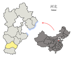
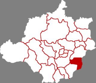
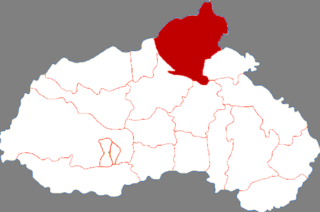
Pingxiang County is a county under the administration of the prefecture-level city of Xingtai, in the south of Hebei province, China, located about 45 km (28 mi) from downtown Xingtai. It has a population of 280,000 residing in an area of 406 km2 (157 sq mi). In the Han dynasty, Pingxiang County was known as Julu County (钜鹿县) and was the birthplace of Zhang Jue and his brothers Zhang Bao and Zhang Liang, who started the Yellow Turban Rebellion in the 180s.

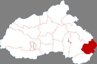
Guangzong County is under the jurisdiction of the prefecture-level city of Xingtai in the south of Hebei province, China. It has a population of 270,000 residing in an area of 493 km2 (190 sq mi).

Dawa District is a district of the city of Panjin, in central Liaoning province of Northeast China. The district has a land area of 1,683 square kilometres (650 sq mi) and a population of 390,000. The postal code is 124200. The district seat is located in Zhanqian Community in Dawa Town. The district was known as Dawa County until 2016, when it was converted to a district.

Neiqiu County is a county in southwest of Hebei province, People's Republic of China, bordering Shanxi province to the west. It is under the administration of the prefecture-level city of Xingtai and has a land area of 775 square kilometres (299 sq mi), and a population of 260,000. The county seat is located in Neiqiu Town.

Lingtai County is a county in the southeast of Gansu province, China, bordering Shaanxi province to the south and east. It is under the administration of Pingliang City. Its postal code is 744400, and in 1999 its population was 226,576 people.

Hejin is a county-level city of Yuncheng City, in the southwest of Shanxi province, People's Republic of China, located on the east (left) bank of the Yellow River. It borders Jishan and Wanrong counties to the east and south, Linfen to the north, and Hancheng in Shaanxi across the Yellow River to the west. As of 2002, it had a population of 360,000 residing in an area of 593 km2 (229 sq mi). The city and its surrounding area is home to abundant aluminium reserves. During the Qin Dynasty, Hejin was known as Pishi County, renamed to Longmen County during the Northern Wei, and finally Hejin County in the Song Dynasty. The city's name (河津) literally means "river ford", due to the need of a fording of the Yellow River at the time. In 1994, Hejin was upgraded to its present status as a county-level city.
Funing County is a district of northeastern Hebei Province, China, located about 30 km (19 mi) to the west of Qinhuangdao, which administers it. As of 2001, it had a population of 510,000 residing in an area of 1,646 km2 (636 sq mi).

Lanling County formerly Cangshan County is a county of southern Shandong province, bordering Jiangsu province to the south. It is under the administration of Linyi City.

Luanping County is a county of northeastern Hebei Province, with the Great Wall of China demarcating its border with Miyun District, Beijing to the southwest. It is under the administration of Chengde City, and as of 2017, has a population of 293,200 residing in an area of 3,195 km2 (1,234 sq mi). The G45 Daqing–Guangzhou Expressway, China National Highways 101 and 112, and the Beijing–Tongliao Railway pass through the county. Other bordering county-level divisions are Fengning County to the northwest, Longhua County to the north, Chengde's core districts of Shuangqiao District and Shuangluan District to the east, and Chengde County to the southeast.

Lincheng County is a county in the southwest of Hebei province, People's Republic of China, in the foothills of the Taihang Mountains. It is under the administration of the prefecture-level city of Xingtai. In 2010, its population was 204,000 and lived in an area of 797 km2 (308 sq mi). It borders Neiqiu in the south, Longyao and Baixiang in the east, Gaoyi and Zanhuang in the north, and the province of Shanxi in the west.

Baixiang County is a county in the southwest of Hebei province, China. It is under the administration of the prefecture-level city of Xingtai, with a population of 193,777 (2014) residing in an area of 268 km2 (103 sq mi). It lies generally to the east of G4 Beijing–Hong Kong–Macau Expressway and China National Highway 107. The Baixiang County is known as being the former capital of the state of Xiang (襄國) of the Southern Huns state Later Zhao, described in the Fang Xuanling Book of Jin Chapter 104, was located in the territory of the county. It was a place of the 351 CE Battle of Xiangguo between Ran Min's army and Shi Zhi of Later Zhao. After the battle, the Later Zhao general Liu Xian (劉顯) killed Shi Zhi in Xiangguo, the Xiangguo city was burned, and its population moved to Yecheng.
Ningjin County is a county in the south of Hebei province, China. It is under the administration of Xingtai City, with a population of 730,000 residing in an area of 1,107 km2 (427 sq mi). Both and G20 Qingdao–Yinchuan Expressway and China National Highway 308 pass through the county.

Wei County or Weixian is a county in the south of Hebei province, China. It is under the administration of the prefecture-level city of Xingtai, with a population of 540,000 residing in an area of 994 km2 (384 sq mi). It is served by G45 Daqing–Guangzhou Expressway and China National Highway 106.