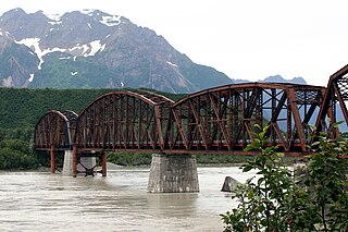
The Miles Glacier Bridge, also known as the Million Dollar Bridge, was built in the early 1900s across the Copper River fifty miles from Cordova in what is now the U.S. state of Alaska. It is a multiple-span Pennsylvania truss bridge which completed a 196-mile (315 km) railroad line for the Copper River and Northwestern Railway, built by J. P. Morgan and the Guggenheim family to haul copper from the old mining town of Kennicott, now located within the Wrangell–St. Elias National Park and Preserve, to the port of Cordova. It earned its nickname because of its $1.4 million cost, well recouped by the about $200 million worth of copper ore which was shipped as a result of its construction.

The Androscoggin Swinging Bridge is a pedestrian suspension bridge spanning the Androscoggin River in Maine between the towns of Topsham in Sagadahoc County and Brunswick in Cumberland County. The bridge was built in 1892 as a timesaving approach for employees of the Cabot Manufacturing Company of Brunswick, could have safer and easier passage across the river.

The Riegelsville Bridge is a suspension bridge crossing the Delaware River at Riegelsville, Pennsylvania, connecting it with Riegelsville, New Jersey, United States.

The Bedell Bridge was a Burr truss covered bridge that spanned the Connecticut River between Newbury, Vermont and Haverhill, New Hampshire. Until its most recent destruction in 1979, it was, with a total length of 382 feet (116 m), the second-longest covered bridge in the United States. The bridge was divided into two spans of roughly equal length, and rested on a central pier and shore abutments constructed from mortared rough stone. The eastern abutment has been shored up by the addition of a concrete footing. The bridge was 23 feet (7.0 m) wide, with a roadway width of 18.5 feet (5.6 m). Because the state line is the western low-water mark of the Connecticut River, most of the bridge was in New Hampshire; only the western abutment is in Vermont.

U.S. Route 64 is a U.S. highway running from Teec Nos Pos, Arizona east to Nags Head, North Carolina. In the U.S. state of Arkansas, the route runs 246.35 miles (396.46 km) from the Oklahoma border in Fort Smith east to the Tennessee border in Memphis. The route passes through several cities and towns, including Fort Smith, Clarksville, Russellville, Conway, Searcy, and West Memphis. US 64 runs parallel to Interstate 40 until Conway, when I-40 takes a more southerly route.

The St. Francis River Bridge carries United States Route 70 over the St. Francis River near Madison in St. Francis County, Arkansas, United States. It consists of three Parker through trusses, each 162 feet (49 m) long, and a swing bridge span 230 feet (70 m) long. With approaches, the bridge has a total length of 921 feet (281 m). The swing span is mounted on a central pier, and is rotated by two workers operating a large hickory handle. The bridge was built in 1932–33, with the swing span design made to accommodate the demands of the United States War Department that the river remain navigable by military vessels. The bridge is one of three swing-span bridges in the state. It is likely that the swinging mechanism has never been used.
The Lee Creek Bridge in Natural Dam, Arkansas was a Pennsylvania through truss bridge that was built in 1934. It was a twin-span bridge with a total length of 587 feet (179 m), which carried Arkansas Highway 59 across Lee Creek. It rested on concrete piers and abutments, had a vertical clearance of 14 feet (4.3 m) and had a roadbed 22 feet (6.7 m) wide.

Chain Bridge or Change Bridge, also known as the Lehigh Canal Swinging Bridge and as Wire Towing Path at Pool No. 8, is a historic change bridge spanning the Lehigh River at Palmer Township and Williams Township, Northampton County, Pennsylvania. It was built in 1856–1857, and consists of three stone piers and two spans. Each pier is approximately 30 feet high. In 1972, the bridge consisted of the piers and the cable.
The bridge that carries Arkansas Highway 274 across Little Cypress Creek, near Thornton, Arkansas in Calhoun County, was listed on the National Register of Historic Places in 1995. The wooden trestle bridge was built in 1940, and is 105 feet (32 m) long and has a total width of 31 feet (9.4 m), with a deck 28.4 feet (8.7 m) wide. It is divided into seven spans, the longest of which is 15 feet (4.6 m). Its abutments and piers are all of wood, and the bridge deck is wood covered with asphalt.
The US 62 Bridge over Crooked Creek is a historic bridge near Pyatt, Arkansas. It carries US Highway 62 (US 62) and US 412 across Crooked Creek, which flows through the center of Pyatt to the northwest.

The Haggard Ford Swinging Bridge is a historic suspension bridge in Boone County, Arkansas. It is located adjacent to Cottonwood Road, about 8 miles (13 km) north of Harrison, and spans Bear Creek. It has cast-in-place concrete abutments, towers, and anchorages, and is supported by steel cables. A wooden deck, one travel lane in width, is suspended from steel hangers. The bridge is about 160 feet (49 m) long. The bridge was built 1938–41 with funding from the Works Progress Administration. Fill surrounding the abutments was washed away in 1945 and subsequently replaced. The bridge deck was replaced in 1977.

The Hackett Creek Bridge is a historic bridge near Hackett, Arkansas, which carries Arkansas Highway 45 across Hackett Creek. The bridge is a three-span concrete structure set on abutments and piers of stone and concrete. The longest single span is 36 feet (11 m) long, and the total bridge length is 98 feet (30 m). The deck is asphalt laid over concrete, and there are simple concrete railings on either side. Built in 1941, it is a well-preserved concrete bridge of the period.

The Mountain Fork Bridge is a historic bridge in rural Polk County, Arkansas. It carries County Road 38 across Mountain Fork Creek north of Hatfield and southwest of Mena. The bridge consists of two spans of steel Pratt pony trusses, with a total length of 406 feet (124 m), including approach spans. The trusses are set on piers consisting of steel rings filled with concrete; each of these spans is 80 feet (24 m) long. The bridge's construction date and builder are unknown; it predates the standardization of bridge designs in the state in 1923. It is estimated to date to the early 1900s.
The Sylamore Creek Bridge is a historic bridge in east central Stone County, Arkansas, just south of the Ozark-St. Francis National Forest. It carries County Road 283 across Sylamore Creek, a short way west of Arkansas Highway 9 and north of the Holiday Mountain Resort in Allison. It is a wire-cable suspension bridge, with steel towers mounted on concrete piers supporting four main cables that are anchored into concrete abutments. The bridge is 202 feet (62 m) long, with a deck width of 19 feet 6 inches (5.94 m) and a clearance height of 11 feet (3.4 m). Built in 1945, it is one of three known wire-cable bridges in the state.

The Harp Creek Bridge is a historic bridge in rural northern Newton County, Arkansas, carrying Arkansas Highway 7 across Harp Creek in the hamlet of Harrison. It is an open-spandrel arch bridge, built out of reinforced concrete in 1928 by the Luten Bridge Company. The arches span 69 feet (21 m), and are mounted on piers set 24 feet (7.3 m) from the abutments. The total structure length is 117 feet (36 m), and the deck is 23 feet (7.0 m) wide. Concrete balustrades line the sides of the bridge.

The Judsonia Bridge is a historic bridge, carrying Van Buren Street across the Little Red River on the south side of Judsonia, Arkansas. It is a three-span metal truss swing bridge, with a total structure length of 397 feet (121 m). Its center span is 266 feet (81 m) long, and is mounted on a pivot on a central pier. It and the two approach trusses are all Warren trusses. Built in 1924, it is one of three known swing bridges in the state, and the only one with a cantilevered swinging truss. It was closed to traffic in 2007, and reopened in 2013 after restoration.
The Cove Creek Bridge was a historic bridge in rural eastern Conway County, Arkansas. It carried Arkansas Highway 124 across Cove Creek, just west of the hamlet of Martinsville, and west of the city of Twin Groves. It was a three-span steel structure with a total length of 267 feet (81 m). The main span was a Pratt through truss 101 feet (31 m), mounted on concrete piers, while the approach spans on either end were smaller pony trusses each 83 feet (25 m) long. The bridge was built in 1957, and was the one of few Pratt truss bridges in the state.

The Big Piney Creek Bridge is a historic bridge, carrying Arkansas Highway 123 across Big Piney Creek in Ozark-St. Francis National Forest, northeast of Hagarville, Arkansas. Its main span is a Warren through truss structure, 141 feet (43 m) in length, with steel deck girder approach spans giving the bridge a total length of 461 feet (141 m). The trusses are mounted on concrete piers. The bridge was built in 1931, during a period of financial hardship, and was for economic reasons built with a single-lane 12-foot (3.7 m) roadway.
The Petit Jean River Bridge is a historic bridge in rural southern Logan County, Arkansas. The bridge carries Old Highway 109 across the Petit Jean River between Sugar Grove and Magazine. It consists of a single-span steel Pratt through truss and two masonry approach spans, set on concrete piers in the river. The total structure length is 273 feet (83 m), with a roadway width of 19 feet (5.8 m) and a total width of 24 feet (7.3 m). The bridge was built in 1938.

Baring Bridge is a one-lane wood and steel cable suspension bridge crossing the South Fork Skykomish River in Baring, Washington, United States. It carries Index Creek Road, which connects a rural area to U.S. Route 2 in unincorporated King County. Built in 1930, it is one of only two wooden suspension bridges designed for vehicle use in Washington that remain active and was added to the National Register of Historic Places in August 2019.

