The Hmar language belongs to the Mizo language branch of the Sino-Tibetan family of languages. The speakers of this language use Mizo language as their second language (L2).

Nagas are various ethnic groups native to northeastern India and northwestern Myanmar. The groups have similar cultures and traditions, and form the majority of population in the Indian state of Nagaland and Naga Self-Administered Zone of Myanmar (Burma); with significant populations in Manipur, Arunachal Pradesh and Assam in India; Sagaing Region and Kachin State in Myanmar.

Pakokku is the largest city in the Magway Region of Myanmar. It is situated about 30 km northeast of Bagan on the Irrawaddy River. It is the administration seat of Pakokku Township, Pakokku District and Gangaw District. Pakokku Bridge is part of the India–Myanmar–Thailand Trilateral Highway and is the longest bridge in Myanmar. It is home of the Pakokku Airport.
Tamu is a town in the Kabaw Valley in the Sagaing Region in north-west Myanmar near the border with the eastern Indian state of Manipur. It is a principal town of the Kabaw Valley and the seat of administration for the Tamu Township. Opposite the Indian town of Moreh, it is home to an official border trade posts with India, which opened on 12 April 2005. In 2022, total trade volume at the border post stood at US$15.134 million.

The Battle of Pakokku and Irrawaddy River operations were a series of battles fought between the British Indian Army and the Imperial Japanese Army and allied forces over the successful Allied Burma campaign on the China Burma India Theater during World War II. The battles and operations were instrumental in facilitating the eventual capture of Rangoon in summer 1945.
Moreh is a border town located on the India–Myanmar border in Tengnoupal district of the Indian state of Manipur. As a rapidly developing international trade point with the integrated customs and international immigration checkpoint, Moreh plays an important role in India's Look East Policy, trade and commerce under ASEAN–India Free Trade Area, India-Myanmar relationship, India–Myanmar–Thailand road connectivity, and Trans-Asian Railway connectivity.

Ton Zang Township is a township of Tedim District in the Chin State of Myanmar. The 3,471.24-square-kilometre Ton Zang township is bordered by Tedim (Tiddim) Township in the south, Kale Township of the Sagaing Division in the south-east, Tamu Township of the Sagaing Division in the north-east, the Indian state of Manipur in the north and the Indian state of Mizoram in the west.

Kalay, also known as Kale, is a town in the Sagaing Region of Myanmar. It is located upstream from Mandalay and Monywa on the Myittha River, a tributary of the Chindwin River. The town is the district headquarters of the Kalay District. It has gained importance with trans border movement enabled between Myanmar and India following the 165 kilometres (103 mi) Tamu–Kalay section of India–Myanmar–Thailand Trilateral Highway built by the Border Roads Organization of India under the Look-East Connectivity policy. Consequently, Kalay is now one of the fastest developing towns in Myanmar.
The Kabaw Valley also known as Kubo valley is a highland valley in Myanmar's western Sagaing Division, close to the border with India's Manipur. The valley is located between Yomadong range of mountains, which constitute the present-day India–Myanmar border, and the Chindwin River.
Gede is the last railway station on the Indian side of the Bangladesh–India border in Krishnaganj CD Block in Nadia district in the Indian state of West Bengal. The corresponding station on the Bangladesh side is Darshana. It is the terminal station on the Sealdah–Gede section of Kolkata Suburban Railway system. There is a border checkpoint at Gede.
Hkamti District or Khamti District is a district in northern Sagaing Division of Burma (Myanmar). Its administrative center is the town of Singkaling Hkamti.
Mawlaik District is a district in central Sagaing Division in north-west Burma (Myanmar). Its administrative center is the town of Mawlaik.
Tamu District or Tuimu District is an administrative district in Sagaing Division, Burma (Myanmar). Its administrative center is Tamu Town.
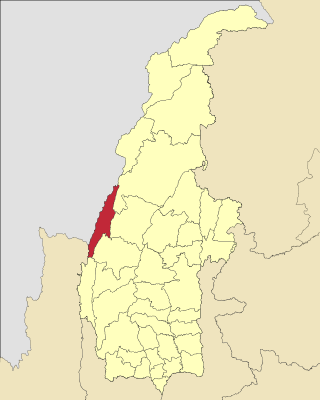
Tamu Township is a township in Tamu District in the Sagaing Division of Burma. The principal town is Tamu. Tamu township is the only township of Tamu District, which borders India.
Ainggyi is a village in the Mandalay Region of north-west Myanmar. It lies in Nyaungu Township in the Tamu District.
Mahisasan is a border railway station and a defunct railway transit facility point on the India–Bangladesh border in Karimganj district in the Indian state of Assam. The corresponding station on the Bangladesh side is Shahbajpur in Sylhet District. The border station is linked to Karimganj 11 kilometres (6.8 mi) away. The Mahisasan–Shahbajpur route has not been operational since December, 1996 due to lack of traffic.
The Anglo-Manipur War or Manipuri Rebellion of 1891 was a short armed conflict between the British Colonial Forces and the dissenting royal princes of Manipur Kingdom, which was arguably a dependency of the British Empire in India. The conflict began with a palace coup staged by the general (Senapati) of Manipur, ousting its reigning king, and installing a half-brother in his place. The British government took objection to the action and attempted to arrest the general. The effort failed, with the Manipuri forces attacking the British residency and the resident and other British officials getting executed. The British launched a punitive expedition that lasted from 31 March to 27 April 1891. The general and other rebels were arrested and convicted. The British annexed Manipur and governed it as a princely state till 1947.

Meuseukat is an dodol-like cake found in Acehnese cuisine. The cake is made using flour, sugar, a mixture of pineapple and lemon juice, and butter. The pineapple used in the cake imparts a yellow hue. Meuseukat is typically served on special occasions, such as during wedding festivities, and religious celebrations like Eid al-Fitr and Eid al-Adha.
Kanan is a village in the Kanan village tract, Tamu Township, Sagaing Region, Myanmar. The village is located north of the town of Khampat in Tamu Township.


