
The Templeton Common Historic District encompasses the historic town center of Templeton, Massachusetts. Laid out in the 1750s, the area has been the focus of the town's civic and economic affairs since, and includes its finest assortment of 18th and early 19th-century architecture. The district was added to the National Register of Historic Places in 1983. The district was in 2010 named as one of the 1,000 places to visit in Massachusetts by the Great Places in Massachusetts Commission.

The Sheffield Plain Historic District encompasses the original 18th-century village center of Sheffield, Massachusetts, United States. The linear district extends southward about 0.5 miles (0.80 km) from the junction of United States Route 7 and Cook Road, where the original town common is located. The district was primarily developed in the mid-18th and early 19th centuries. It was listed on the National Register of Historic Places in 1988.

The South Lee Historic District encompasses the historic portion of the village of South Lee in Lee, Massachusetts. Extending mainly along Massachusetts Route 102 between Fairview Street and the Stockbridge town line, the village is a well-preserved 19th-century mill village, with fine Federal and Greek Revival buildings and a later 19th-century paper mill. It was listed on the National Register of Historic Places in 1999.

The East Village Historic District is a historic district encompassing the center of the East Village of Amherst, Massachusetts, United States. It includes properties on Main Street, North East Street, and South East Street. The village was one of Amherst's principal civic and commercial centers until the arrival of the railroad in Amherst Center in 1853, and remained a primarily residential area thereafter. The district was listed on the National Register of Historic Places in 1986.

The Woodbridge Street Historic District is a predominantly residential historic district in South Hadley, Massachusetts, United States. It extends from the junction of Woodbridge Street and Silver Street north roughly to Woodbridge Terrace. This area was one of the first to be settled in South Hadley, and includes its oldest buildings, which date to the 1720s. It also has the community's highest concentration of high-quality 18th-century residential architecture. It was listed on the National Register of Historic Places in 1983.

The Lincoln–Sunset Historic District is a residential historic district located west of the downtown area of Amherst, Massachusetts. Colloquially known as Millionaire's Row, the district extends along Lincoln and Sunset Avenues between Northampton Street and the campus of the University of Massachusetts, Amherst. This area was one of Amherst's first planned residential subdivisions, and features a large number of high-quality houses, built by merchants, businessmen, and academics. It was added to the National Register of Historic Places in 1993.

The North Amherst Center Historic District encompasses the center of North Amherst, part of the town of Amherst, Massachusetts. It is a well-preserved example of a traditional farming village, centered at the five-way junction of Meadow, Pine, and North Pleasant Streets, and Sunderland and Montague Roads. The area developed as a village center in the early 19th century and has been relatively little changed since the late 19th century. The district was added to the National Register of Historic Places in 1991.
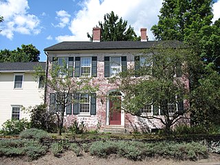
The South Amherst Common Historic District encompasses the village common and surrounding buildings of South Amherst, Massachusetts. This area developed as a rural residential village hub in the 18th and 19th centuries. It was listed on the National Register of Historic Places in 1995.

The Hollis Village Historic District encompasses the historic village center of Hollis, New Hampshire. The district is centered on Monument Square, which connects Main Street to Depot Street and Broad Street. It covers about 400 acres (160 ha), and extends along all three of those roads for some distance, and includes properties on Silver Lake Road and Ash Street. Most of the buildings in the district are residential or agricultural in use, and date before the turn of the 20th century; the oldest buildings date to the mid-18th century. The "Always Ready Engine House", which occupies a triangular parcel at the western end of Monument Square, was built in 1859, and is the town's oldest municipal building. Its most architecturally sophisticated building is the town hall, built in 1887 to a design by William M. Butterfield of Manchester. The district represents the growth of a mainly agricultural community over a 200-year period. The district was listed on the National Register of Historic Places in 2001.
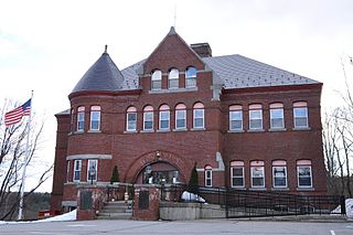
The Pittsfield Center Historic District encompasses the civic and commercial heart of Pittsfield, New Hampshire. This area is defined by a roughly square bend in the Suncook River, whose power provided an impetus for the development of the town in the 19th century. The dominant feature of the district was the 1827 Joy Cotton Mill, a four-story brick building at the base of Main Street. It was damaged in a fire, and some of its features were reused in the construction of the present building according to a historic sign in front of the building. There are three churches, including the 1863 Gothic Revival St. Stephen's Episcopal Church, and the town office building, a significantly altered 1789 meeting house. The district also includes the main commercial district and some of the surrounding residential areas. It was listed on the National Register of Historic Places in 1980.

The Canaan Street Historic District encompasses the historic original town center of Canaan, New Hampshire. It is a basically linear district, running along Canaan Street roughly from Prospect Hill Road in the north to Moss Flower Lane in the south. The town flourished first as a stagecoach stop, and then as a resort colony in the late 19th century. The historic district was listed on the National Register of Historic Places in 1973. It included 60 contributing buildings.

The Lyme Center Historic District encompasses a modest crossroads and industrial village in rural Lyme, New Hampshire. The predominantly residential district stretches along Dorchester Road, on either side of its junction with Baker Hill Road. The village's rise in development started in the early 19th century as it was at a crossroads of the east-west Dorchester Road, and the north-south Baker Hill Road and Acorn Hill Road. The village grew rapidly in the 1820s, with a number of simple Greek Revival houses, and in 1830 the Baptist Church was built. The other major civic building in the village is the Lyme Academy, built in 1839, albeit with more Federal than Greek Revival styling. Grant Brook, which runs parallel to Dorchester Road, provided a source of power for the growth of small industrial efforts, including a sawmill at the corner of Dorchester and Baker Hill Roads. This industry provided a second minor building boom in the late 19th to early 20th century. Most of the houses in the district are vernacular Greek Revival or Cape in their styling; probably the most elaborate Greek Revival house is the 1857 Beal-Pike House at 41 Dorchester Road.
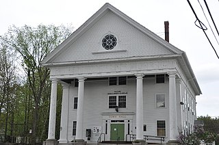
The Bedford Town Hall is located at 70 Bedford Center Road in Bedford, New Hampshire. Built in 1910, it is a prominent early work of Chase R. Whitcher, a noted architect of northern New England in the early 20th century. The building is the third town hall to stand on this site, and was listed on the National Register of Historic Places in 1984.

Hansen's Annex is a historic house on Main Street in Center Sandwich, New Hampshire, United States. Built about 1839, it is one of a small number of Greek Revival buildings to survive, out of many that once graced the town. It has seen use as a single-family residence, tavern, and boarding house. It was listed on the National Register of Historic Places, and included in the Center Sandwich Historic District, in 1983.

The Hancock Village Historic District encompasses the town center of Hancock, New Hampshire. It extends the length of Hancock's Main Street, from Pine Ridge Cemetery and the common to the west, and the junction of Bennington, Norway Hill, and Forest roads to the east. It then extends a short way up Bennington Road. The common was laid out in 1785, and the village developed nearby over the next 100+ years. The district was listed on the National Register of Historic Places in 1988.

The Lower Corner Historic District encompasses a small village center in the town of Sandwich, New Hampshire. Lower Corner is a rural village that is strung along New Hampshire Route 109 on either side of its junction with School House Road, about one mile from the main village of Center Sandwich. The village was developed relatively early in Sandwich's history, although its oldest buildings now date to the early 19th century. There are 25 contributing structures, mostly residences. There are two buildings built as stores, including one of brick; all the other buildings are wood frame. The district was listed on the National Register of Historic Places in 1986.
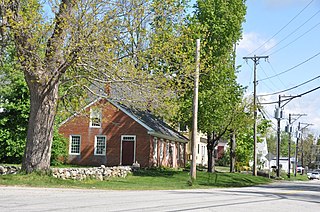
The New Ipswich Center Village Historic District encompasses the historic center of the rural town of New Ipswich, New Hampshire. The center village is the town's most densely populated area, with a history dating to the town's founding in 1735. The district extends along Turnpike Road between King and Porter Roads, and southward in a roughly triangular shape, the southern point of which is at the junction of Main Street and Willard Road. The village includes a large number of residences, which were mainly agricultural at first, but also include a number of properties built as summer resort houses in the late 19th and early 20th centuries. It also includes most of the town's historic civic buildings, including its historic town hall, and the Barrett House, now a museum property owned by Historic New England. The district was listed on the National Register of Historic Places in 1991.

The Town Center Historic District encompasses the historic village center of South Hampton, New Hampshire. Centered around the Barnard Green, the town common, on New Hampshire Route 107A, it includes architectural reminders of the town's growth and change over time. The district was listed on the National Register of Historic Places in 1983.

The Dudley Hill Historic District encompasses the historic heart of Dudley, Massachusetts. The historic district is essentially linear, extending along Center Street between Dudley Hill and Tanyard Roads. This area was the first to be settled in the mid-17th century, and is composed mainly of civic, religious, and residential buildings dating to the 18th and 19th centuries. The district listed on the National Register of Historic Places in 2001.
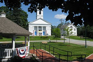
The Oakham Center Historic District encompasses a portion of the historic town center of Oakham, Massachusetts. Roughly bounded by Coldbrook Rd., Maple St., Barre Rd., and Deacon Allen Drive, the area was formed as a civic center about 1770, with town incorporation following in 1775. It includes a well-preserved variety of early 19th-century residential architecture, as well as the town's Greek Revival Congregational church, and its 1908 library. The district was listed on the National Register of Historic Places in 2020.


