Bennington is a town in Hillsborough County, New Hampshire, United States. The population was 1,501 at the 2020 census.

Hancock is a town in Hillsborough County, New Hampshire, United States. The population was 1,731 at the 2020 census. Hancock is home to the Welch Family Farm Forest.

New Hampshire Route 31 is a 56.148-mile-long (90.361 km) north–south state highway in southern New Hampshire. It runs from Mason on the Massachusetts border, where, as Greenville Road, the road becomes Massachusetts Route 31. It passes through Greenville, Wilton, Lyndeborough, Greenfield, Bennington, Antrim, Hillsborough, Windsor, and Washington, reaching its northern terminus of Goshen at New Hampshire Route 10.

The Hotchkissville Historic District is a historic district in the town of Woodbury, Connecticut, United States that was listed on the National Register of Historic Places in 1995. The district encompasses most of the historic village of Hotchkissville, which is centered at the junction of Washington and Weekeepeemee roads. The village began as a dispersed rural agricultural community, but developed in the 19th century with the arrival of industry, primarily the manufacture of textiles. Despite this, the village has retained a significantly rural character, and includes a broad cross-section of 18th- and 19th-century architectural styles.

The East Jaffrey Historic District is a historic district running roughly along NH Route 124 through Jaffrey, New Hampshire. It encompasses what is now the economic and civic heart of the town, centered on the Jaffrey Mills and the crossing of the Contoocook River by Route 124. It extends as far west as St. Patrick's Church beyond Charlonne Street and as far east as the US Post Office building at Route 124 and Ellison Street. To the north it extends along Peterborough Street to Christian Court, and to the south it extends along River Street and School Street to their junction. The district includes early 19th-century residential structures, as well as industrial buildings and housing associated with the Jaffrey Mills which arose in the mid-19th century. The district was added to the National Register of Historic Places in 2002.
The North Stonington Village Historic District is a 105-acre (42 ha) historic district encompassing the historic center of the main village of North Stonington, Connecticut. The district includes a well-preserved small industrial village, which flourished in the years before the American Civil War, and declined afterward. The district was listed on the National Register of Historic Places in 1983.

The West Chesterfield Historic District is a historic district that encompasses the 19th century industrial and residential heritage of the village of West Chesterfield in the town of Chesterfield, Massachusetts. Centered at the junction of Main Road and Ireland Street, it was one of the town's main industrial sites for many years. The district was listed on the National Register of Historic Places in 2008.
The Suncook Village Commercial–Civic Historic District encompasses the civic and commercial heart of Suncook, New Hampshire, a village on the Suncook River in Pembroke and Allenstown. The civic district is a 3-acre (1.2 ha) area on the Pembroke side of the river, adjacent to the Pembroke Mill, a site that had seen industrial use since the 18th century. The district includes 21 commercial buildings, 19 of which are historically significant. The district was listed on the National Register of Historic Places in 2005.

The Jaffrey Mills is a historic mill complex at 41 Main Street, in the central business district of Jaffrey, New Hampshire. It consists of a connected series of primarily brick buildings flanking the Contoocook River just north of Main Street. Its oldest buildings, the original mill and office building, are on the west side of the river. They were built in 1868, and feature mansard roofs and banded dentil brick cornices. The mill building has a tower that originally sported a cupola, but this was removed early in the 20th century. In 1872 the building on the east side was built, and the two sides joined by timber-frame bridges were added in 1897, at the same time the east building was extended northward. Later additions to the north of the east building include a storage area and a loading dock. The mill complex, the only 19th-century industrial complex of its type to be built in Jaffrey, was listed on the National Register of Historic Places in 1982. It has been converted into residences.
The Enfield Village Historic District encompasses the historic 19th century village center of Enfield, New Hampshire. The district was listed on the National Register of Historic Places in 2010. Multiple buildings of the district were added to the New Hampshire State Register of Historic Places in 2012.

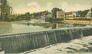
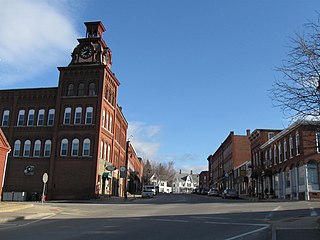
The Contoocook Mills Industrial District of Hillsborough, New Hampshire, encompasses the industrial mill complex of the Contoocook Mills, a major business in the town from the 19th century to the mid-20th century. Industry on the banks of the Contoocook River in Hillsborough began as early as 1763, when a sawmill and gristmill were operated in the area. More modern industrial activity began in 1828 with the construction of a cotton mill by Josiah Marcy. This three story timber frame building stands on the south side of Mill Street, on a granite foundation through which a raceway provide the water which powered the mill. Marcy expanded his operations, building a grist mill and saw mill before his death in 1848. The grist mill, a handsome brick building on the north side of Mill Street, was operated as such until 1884, after which it was converted into the picker building for the main mill complex.

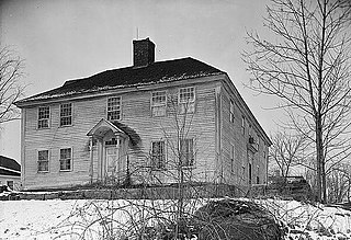
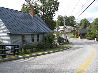
The Hancock Village Historic District encompasses the town center of Hancock, New Hampshire. It extends the length of Hancock's Main Street, from Pine Ridge Cemetery and the common to the west, and the junction of Bennington, Norway Hill, and Forest roads to the east. It then extends a short way up Bennington Road. The common was laid out in 1785, and the village developed nearby over the next 100+ years. The district was listed on the National Register of Historic Places in 1988.
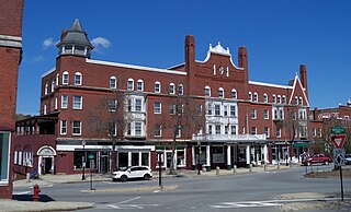
The Central Business District of Claremont, New Hampshire, is centered on Broad Street Park and the Claremont Opera House, and the area between the park and the Sugar River, whose power was responsible for Claremont's growth in the 19th century. The district was listed on the National Register of Historic Places in 1978.

The Newmarket Industrial and Commercial Historic District encompasses the heart of a distinctive 19th century mill town, Newmarket, New Hampshire. Its mill complex is regionally distinctive for its extensive use of stone from an early date, and the town is relatively well-preserved due to a significant economic decline after the mills closed in 1920. The district was listed on the National Register of Historic Places in 1980. The Stone School, listed in 1978, is a contributing resource.
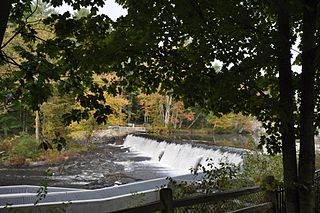
The Wiswall Falls Mill Site is a historic archaeological industrial site in Durham, New Hampshire. It is located in John Hatch Park, a small public park just south of Wiswall Road on the eastern bank of the Lamprey River. The 3-acre (1.2 ha) site encompasses the remains of a small 19th-century mill complex that was one of Durham's major industrial sites of the 19th century until it burned in 1883. The site, which includes remains of the waterworks and foundations, was listed on the National Register of Historic Places in 1988.

The Quechee Historic Mill District encompasses the historic heart of the village of Quechee, Vermont, a well-preserved 19th-century mill village. Extending along Quechee Main Street between the Old Quechee Road and the Quechee-West Hartford Road, the village was settled in the 1760s, and has an industrial history extending into the 20th century. It was listed on the National Register of Historic Places in 1997.
The Springfield Downtown Historic District encompasses the historic central business district of the town of Springfield, Vermont. Located in a narrow valley on the banks of the Black River, the town's architecture is primarily reflective of its importance as a manufacturing center in the late 19th and early-to-mid 20th centuries, with a cluster of commercial buildings surrounded by residential and industrial areas. It was listed on the National Register of Historic Places in 1983, and enlarged slightly in 1986.

The Thetford Center Historic District encompasses the village of Thetford Center in Thetford, Vermont. The village contains a well-preserved collection of early to mid-19th century architecture, a legacy of its period of greatest prosperity as an agricultural and industrial center. It was listed on the National Register of Historic Places in 1998.

The Warren Village Historic District encompasses the village center of Warren, Vermont, United States. Stretched mainly along Main Street east of the Mad River, it is a well-preserved 19th-century mill village, although most of its period mill infrastructure has been lost. The district has good examples of Greek Revival, Italianate, and Second Empire architecture. It was listed on the National Register of Historic Places in 1992.

The Manchaug Village Historic District is a historic district encompassing the 19th century industrial village center of Manchaug in Sutton, Massachusetts. Developed in the 1820s around textile mills on the Mumford River, it was the largest industrial area in Sutton, with at least three mill complexes in operation. The district is centered on the junction of Main Street with Manchaug, Putnam Hill, and Whitins Roads.


